Friday, 25 March 2022

North Korea's Hwasong-17 ICBM: capable of (briefly) bringing warheads into orbit?

image: KCNA/RodongSinmun

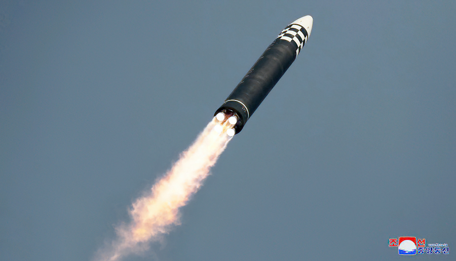
According to multiple western sources and North Korea, North Korea conducted a first full-power test-flight of its new Hwasong-17 ICBM on March 24, 2022, at 5:34 UT, from Sunan close to Pyongyang.

The Hwasong-17 is the Behemoth missile that was first revealed to the outside world one-and-a-half-years-ago during the 2020 October 10 parade in Pyongyang and surprised everyone by its massive size at the time. It is North-Korea's largest, heaviest missile so far and visually looks like a Hwasong-15 on steroids.

[NOTE: some sources are now casting some doubt on the missile identity, suggesting that footage from the failed March 16 launch (see below) was used. See comment at end of post]

The test launch was confirmed by North Korean State sources which produced a written account on their KCNA and Rodong Sinmun websites, accompanied by photographs, while KCNA also broadcast a video of the test. The imagery underlines how impressive the size of the Hwasong-17 is: it is a Monster of a missile!


image KCNA/Rodong Sinmun

 
image KCNA/Rodong Sinmun


image KCNA/Rodong Sinmun

The video report on the test as broadcast by the North Korean State Agency KCNA is spectacular, with a glamour role for the sunglasses-clad North Korean leader Kim Jung Un (look at 3:55 to 4:05 in the video below!). It evokes shades of a Hollywood action movie trailer. 

(the actual footage of the test and test preparations starts at 3:25 in the video, after the usual bombastic introductions by news anchor Ri Chun-hee)


Earlier test flights of components of the same missile might have taken place in Februari and early March (but not on full power), according to western sources. North Korea claimed at the time that it was testing components for a reconnaisance satellite program. 

We also know that on March 16, another test flight from the same launch-site (near Sunan Airport), possibly also a Hwasong-17, failed shortly after launch at an altitude of less than 20 km.

But the March 24 test flight appears to have been successfull, as claimed by both North Korea and western sources. According to North Korean official State sources it reached an apogee at a whopping 6248.5 km altitude, with a ground range of 1090 km and a flight time of long duration (1h 7m 30s).

Western sources that independently tracked the launch mention similar ballpark values for this test: apogee "6200 km" and range "1080 km" according to the S-Korea Joint Chiefs of Staff; apogee "6000 km" and range "1100 km" according to the Japanese Government. The missile came down in front of the Japanese coast inside Japan's EEZ, at some 180 km from Cape Tappi. 

The apogee is at an extreme altitude, and this test was hence extremely lofted, as can be seen in this trajectory reconstruction I made:


click to enlarge

Looking into the necessary impulse in order to assess maximum range of the missile, I realized that the resulting nominal impulse of 7.85 km/s I reconstruct, actually means that the Hwasong-17 can achieve orbital speed. In other words: this means it is powerfull enough to, in principle, loft a payload to (low) earth orbit and get it (briefly) orbital!

Objects can complete at least one revolution around the earth if they have enough orbital velocity such that they can orbit at at least 100 km altitude (the exact value of the lower limit of orbital flight is debated: for circular orbits it might be possible at altitudes as low as 80-90 km, but it anyway strongly hinges on the drag characteristics of the object in question). The corresponding orbital speed at 100 km altitude is 7.84 km/s (for a circular orbit). The nominal impulse I get for the March 24 launch, at 7.85 km/s, matches that (in reality, it is more complex, as the missile will experience atmospheric drag during the initial phase of launch, which was not part of my reconstruction. And part of the initial impulse will be lost due to gravity pull before reaching 100 km altitude).

So in theory, this missile could briefly get an object (e.g. a warhead) in orbit around the earth, rather than on a suborbital ballistic trajectory. In case you wonder: it didn't on March 24, because it was not launched on an orbit insertion trajectory, but rather straight up.


image: KCNA/RodongSinmun

image: KCNA/Rodong Sinmun

image: KCNA/Rodong Sinmun


This was not something I had expected. But it gives a new meaning to North Korean claims from earlier this year that tests conducted then, possibly with Hwasong-17 components, where in connection to a space launch program.

They did fairly and squarely present the latest March 24 test as an ICBM  test flight though.

The launch location at 39.188 N, 125.667 E (as geolocated from the imagery by Joseph Dempsey) was on a concrete strip about 1.75 km from the main buildings of Pyongyang Sunan airport. That concrete strip is part of the Si-Li Ballistic Missile Support Facility which itself is some 2.5 km southwest of the airport:

click map to enlarge

click map to enlarge

But let's get back to the realization that this missile can apparently reach orbital speeds. This means that it - or components of it - in theory can be used for road mobile satellite launches. But it can also mean that you can briefly bring a warhead in orbit, either for a full revolution or more, or - cough - for a "fractional" orbit....

Remember the discussion of the Chinese test of a FOBS ('Fractional Orbital Bombardment System') in July last year?! See this earlier post.

I have been doing some modelling. Based on specs of an early '60-era US warhead, the W56, I modelled whether a launch of a similar warhead into a very low 100 x 105 km, 98.0 degree inclined polar orbit from Sunan, could reach the USA. 

I used the General Mission Analysis Tool for this, with the MISE90 model atmosphere and F10.7 solar flux set at 100. I modelled for a 275 kg warhead with assumed Cd 1.0 and a drag surface of ~0.15 m2 (comments on how realistic those values are, are welcome) and under the assumption that the launch vehicle does achive sufficient orbital speed to insert it in such a 100 x 105 km orbit. The modelled launch was in southern direction, taking the long but undefended southern Polar route over Antarctica, approaching the USA from the south after finishing just over half an orbital revolution. [info added later: The model is strictly for the warhead assuming release from the missile upon orbit insertion: I did not model prolonged coasting as part of a post-boost vehicle of any kind].

With the mentioned specifications, I model it to nominally come down fairly and squarely in Ohio (or any other place within the continental USA if you adjust the orbital plane launched into somewhat), as the map below in which I have plotted the modelled trajectory for the warhead shows....

click map to enlarge
 

So: is the development of this missile perhaps a prelude to the development of a North Korean FOBS? With a suitable warhead, it appears they could do it with this missile.

Incidentally: the flight-time of the March 24 test was similar to the on-orbit flight time needed to get from Sunan to the United States via the southern polar route. But that is likely coincidence.

Leaving FOBS aside for the moment: at any rate a missile with this power launched on a more conventional ballistic trajectory can easily reach any location within the continental United States, as well as Europe and the Pacific (but would need a working reentry vehicle of course, which is another matter). In addition to that, it means that North Korea now in theory also has a potential road-mobile reconnaisance satellite launcher in their arsenal.


image: KCNA/Rodong Sinmun

image: KCNA/Rodong Sinmun

image: KCNA/Rodong Sinmun


image: KCNA/Rodong Sinmun


Added note: some sources are now casting some doubt on the missile identity, suggesting (with arguments from image analysis) that footage from the failed March 16 launch was perhaps presented by North Korea as being from the March 24 launch. The added suggestion is that the March 24 test missile might have been a Hwasong-15, not a Hwasong-17 as North Korea is claiming.

These objections are interesting, but multiple scenario's are possible. For example, they might have used footage from both test launches, certainly if iconic scripted propaganda scenes (e.g. KJU marching in front of the TEL leading his Rocket men) were shot during the preparations for the failed March 16 test. North Korea has been known to have doctored launch imagery for aesthetic/propaganda purposes before in the past, as I have shown for the historic first Hwasong-15 launch of 28 November 2017.

Whatever missile it really was: the missile performance shown by this test is remarkable and well beyond that of earlier North Korean ICBM launches. Western tracking of the missile test confirms the performance, so it is not just North Korean propaganda that can easily be waved away. This is a significant development, no matter how you look at it.

Wednesday, 9 February 2022

This week: rainshowers with a slight chance of falling satellites

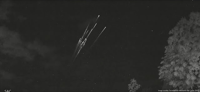
The spectacular image above is a frame from video footage obtained by cameras at AƱasco, Puerto Rico, part of a cameranetwork from the Sociedad de Astronomia del Caribe (SAC). It was shot on 7 February 2022 near 6:40 UT (2:40 local time) and shows what clearly is a satellite reentry, the reentering satellite spectacularly breaking up into many fragments.

Below is the actual video. It shows two objects appearing about 1 minute apart, both reentering and fragmenting. Especially the second object is spectacular. The two objects could belong to one object that has broken up earlier; or be two separate objects close together in the same orbital plane.


The reentering object(s) can be identified as belonging to a batch of 45 49 Starlink satellites launched on 3 February 2022, two-and a half days before the reentry sighting from Puerto Rico.

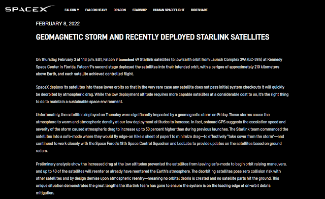
A day after the launch, when most of the deployed satellites yet had to raise their orbits, a Coronal Mass Ejection (CME) from the Sun arrived at earth, creating a geomagnetic storm. 

During a geomagnetic storm, the upper atmosphere warms up and expands somewhat, causing an increase in drag in low orbital altitudes. SpaceX therefore put their just launched satellites, still in a very low orbit, into safe mode and a least-drag attitude. 

This however prevented them from raising their orbits, and it did so long enough to make it impossible for some 40 of them to be rescued. Over the past days a number of them (at least three, possibly more, including the object over Puerto Rico, at time of writing (9 February 16:00 UT)) have already reentered and the other objects, some 40 in total according to SpaceX, will reenter over the coming week.

Fourty (40!) satellites reentering in only a week or so, is unique. The coming week, the chances of seeing a satellite reentry are therefore larger than usual for anyone between 53 N and 53 S. So keep an eye on the sky!

screenshot of Feb 8 announcement on the SpaceX website

Though it remains to be seen which of the 40 satellites it actually was, the Feb 7, 6:40 UT, Puerto Rico sighting can be possitively linked to this deluge of decaying Starlink satellites. 

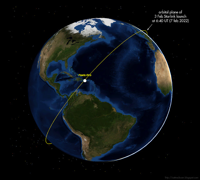
One clue is that the orbital plane of this launch was over Puerto Rico near the time of the event, and the direction of movement (SW-NE) matches it.


To get even more certainty, I did some astrometry on the footage and fitted a rough circular orbit to the measured positions.The rough orbital fit I get - I measured three fragments-  yield orbital inclinations in the range of 54-56 degrees: Starlink satellites are in 53.2 degree inclined orbits, so this is close enough (given the error margin) to conclude that the reentering object fits with the Starlink orbital plane. The RAAN values also match to a degree or so. So there is very little doubt that this was a Starlink satellite reentering.

One reason why I checked this, is that someone suggested another candidate, a Falcon 9 rocket stage from a 2017 launch (2017-014B), which was also expected to reenter around this date (in fact it had already reentered a day earlier) and had its orbital plane passing over Puerto Rico at the time of the event. This rocket stage however had an orbital inclination of 22 degrees, which is clearly much lower than what I get for the reentering object in the footage.

Starlink satellites are not very big and do not have big rocket engines, so there is very little chance that anything remains and reaches Earth surface from these reentries: it will all burn up in the atmosphere. 

Note: I thank Eddie Irizarry for alerting me to the Puerto Rico event


UPDATE 17:30 UT (9 Feb 2022):
For some 21 of the 45 49 Starlink satellites in question, orbital elements have now been released by CSpOC. A quick assessment with SatEvo suggests reentries happening over the coming week, up to mid-February.

Wednesday, 2 February 2022

The upcoming classified NROL-87 launch

click map to enlarge


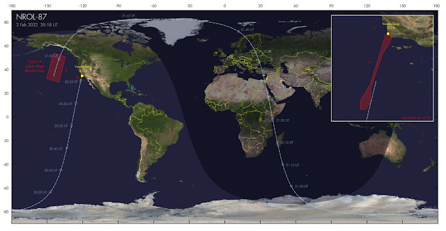
If weather cooperates, SpaceX will launch a classified payload for the National Reconnaissance Office (NRO) on 2 February 2022 at 20:18 UT [the launch eventually was at 21:27 UT]. This launch, from Vandenberg SLC-4 in California, is designated NROL-87.

Both (limited) specifications in a published contract for this launch (which states the intended orbital inclination and semi-major axis as respectively 97.4 degrees and 6890.7 km), as well as the position and orientation of hazard zones published in Navigational Warning NAVAREA XII 45/22 point to a launch into a 97.4 degree inclined, Sun-Synchronous Low Earth Orbit at about 512 km orbital altitude.

Analysts suspect the classified payload is one of a new generation of electro-optical IMINT satellites (either the first, or possibly the second, after USA 290/NROL-71, but in the latter case in a clearly different orbit) that is a follow-up to the KH-11 program. The sun-synchronous character of the intended orbit supports interpretation as an IMINT mission.

The image in top of this post gives the launch trajectory. The hazard areas I plotted in the map are from Navigational Warning NAVAREA XII 45/22 and they match a launch into an orbital plane with the quoted orbital inclination of 97.4 degrees:

280731Z JAN 22
NAVAREA XII 45/22(17,18,19).
EASTERN NORTH PACIFIC.
CALIFORNIA.
1. HAZARDOUS OPERATIONS:
   A. 1907Z TO 2138Z DAILY 02 AND 03 FEB
      IN AREA BOUND BY
      34-42N 120-41W, 34-41N 120-32W,
      34-31N 120-26W, 34-18N 120-30W,
      33-40N 120-53W, 32-10N 121-24W,
      31-25N 121-27W, 31-07N 121-40W,
      31-09N 121-55W, 31-35N 121-52W,
      32-17N 121-27W, 34-29N 120-46W.
   B. 2110Z TO 2249Z DAILY 02 AND 03 FEB
      IN AREAS BOUND BY
      54-00N 144-30W, 50-45N 134-30W,
      29-15N 140-00W, 32-30N 150-30W.
2. CANCEL THIS MSG 032349Z FEB 22.


The Falcon 9 upper stage from the launch makes a controlled reentry at the end of the first revolution, in the Northeast Pacific roughly between Alaska and Hawaii (the red box marked "B" in the map above). 

If launch is indeed near 20:18 UT (the launch window of the Navigational Warning runs from 19:07 to 21:38 UT), then the orbital plane launched into results in passes near noon and midnight local time and (if the semi-major axis is correct) a ~5-6 day repeating ground track. A pre-launch estimated elset is here.

The Launch Patch for NROL-87 shows an Ibex keeping a watchfull eye over its territory:


image: NRO

The North Korean Hwasong-12 test of 29 January 2022

click to enlarge
 

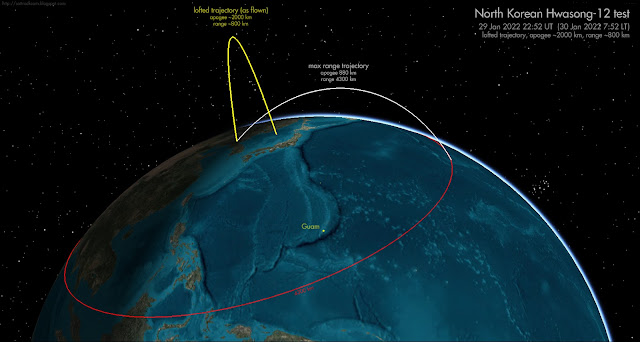
On 29 January 2022 at 22:52 UT (30 January 2022, 7:52 local time in North Korea), North Korea test-fired a Hwasong-12 IRBM. The missile impact point was in the Sea of Japan. According to western sources, it had as flight time of ~30 minutes with a range of ~800 km and an apogee of ~2000 km (the yellow trajectory in the reconstruction above). In other words, a highly lofted trajectory, such as we have seen earlier during various 2017 North Korean missile tests. 

Such a lofted trajectory can be chosen for two reasons: to avoid overflying other countries (Japan) and/or to be able to monitor most of the flight from North Korea itself.

Going from the reporteded apogee altitude and range (~2000 km and ~800 km), I find that this same missile would have an implicated maximum range of ~4300 km (white line in reconstruction above, and red circle) when launched on a more normal, more depressed ballistic trajectory. 

This fits with results for earlier Hwasong-12 lofted test flights, such as the 13 May 2017 test, and is slightly more than the more depressed Hwasong-12 test firings over Japan of 29 August 2017 (which as I have pointed out partly failed but was intended to fly ~3300 km) and 14 september 2017 (which flew ~3700 km).


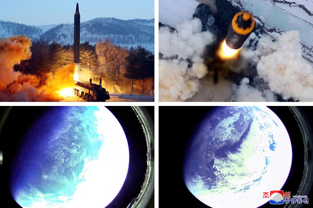
images: KCNA/Rodong Sinmun


Images of the launch published by the North Korean Government in Rodong Sinmun (above) include two images of the earth reportedly made from the missile, showing the Korean peninsula.

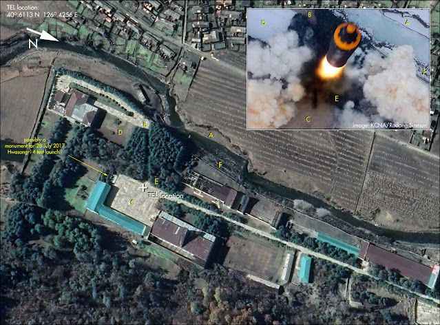
From the two published launch pictures, the launch location of the missile was geolocated by Joseph Dempsey to a spot near Mupyong-ri at 40.6112 N, 126.4257 E. In the image below I match particular terrain details in the drone launch image released by North Korea to a Google Earth image of that particular spot. Which is a familiar spot by the way: it is the same courtyard where on 28 July 2017 the first successful launch of a Hwasong-14 ICBM was carried out (at that time the courtyard was still grass covered: in the meantime it has been paved). On recent Google Earth imagery, what I think could very well be a monument built to commemorate the 2017 launch is visible near the southern courtyard perimeter (we know the North Korean's built commemorative monuments on other test launch sites). I have indicated it in the image below.


click to enlarge

The text of the post-launch North-Korean Government announcement in Rodong Sinmun of 31 January 2022 is interesting. It claims that the  "test-fire was aimed to selectively evaluate the missile being produced and deployed and to verify the overall accuracy of the weapon system". 

As Ankit Panda has pointed out, this probably indicates that this was not a test of a new improved Hwasong-12 variant: but rather a test launch to demonstrate the readiness of a deployed system of production grade missiles (similar to frequent test launches of Minuteman ICBM's and Trident-II SLBM's by the USA). We might therefore see more of such periodical launches in the future.

This was the 7th launch of a Hwasong-12, and the first launch of this type since 15 September 2017.

Friday, 3 December 2021

Some first analytical results on the debris from the Russian ASAT test of 15 November 2021


click image to enlarge
 

In my previous post I discussed the November 15 Anti-Satellite (ASAT) test on the defunct Kosmos 1408 satellite by Russia. On December 1, CSpOC released the first sets of orbital elements for debris fragments created by the test. As of yesterday 2 December, when I made the preliminary analysis presented below, orbits for 207 fragments were published (many more will probably be added in the coming days and weeks). 

They allowed to construct the Gabbard-diagram below, which for each debris fragment plots the apogee altitude (blue) and the perigee altitude (red) against orbital period. They also allowed a preliminary analysis on the delta V's (ejection velocities) imparted on the debris fragments by the intercept.


click diagram to enlarge


Let's first discuss the Gabbard diagram. Gabbard diagrams show you at a glance what the altitude distribution of the created debris fragments is. As can be seen, most of the debris has a perigee (lowest point in the elliptical orbit) near the original orbital altitude of the Kosmos 1408 satellite (490 x 465 km: the intercept happened at an altitude of ~480 km): but a part of the generated debris evidently has been expelled into orbits with perigees (well) below that altitude too. The apogee altitudes (highest point in the elliptical orbit) are mostly scattered to (much) higher altitudes. In all, debris moves in orbits that can bring some debris as low as 185 km and as high as 1290 km. As can be seen, the debris stream extends downwards into the orbital altitudes of the ISS and the Chinese Space Station. About 35% (one third) of the currently catalogued debris has a perigee altitude at or below the orbit of the ISS: about 18% at or below the orbit of the Chinese Space Station. Upwards, the distribution extends well into the altitudes were many satellites in the lower part of Low Earth Orbit are operating, with the bulk of the debris reaching apogee altitudes of 500 to 700 km.

The plots below show the altitude distributions for apogee and perigee of fragments as a bar diagram:

Distribution of perigee altitudes. Click diagram to enlarge

Distribution of apogee altitudes. Click diagram to enlarge

From the change in apogee and perigee altitudes and change in orbital inclination of the debris fragments in comparison to the original orbit of Kosmos 1408, we can calculate the ejection velocities (delta V) involved. It is interesting to do this and compare it to similar data from two other ASAT tests: the Indian ASAT test of 27 March 2019 and the destruction by an SM-3 missile of the malfunctioned US spy satellite USA 193 on 20 February 2008.

In the plot below, I have plotted the density of debris against ejection velocity (in meter/second) for the Nov 15 Russian ASAT test as a bar diagram (with bins of 5 m/s: the blue line is the kernel density):

click diagram to enlarge

In the diagram below, where I have removed the bars and only plotted the kernel density curves, a comparison is made between ejection velocities from the Russian ASAT test and the Indian and US ASAT tests of 2019 and 2008:


click diagram to enlarge

The two diagrams below do the same, in combined bar-graph form, for both the earlier ASAT tests. The first diagram compares the delta V distribution from the Russian ASAT test (blue) to that of the 2008 USA 193 destruction (red); the second diagram does the same but compared to the 2019 Indian ASAT test:

delta V of Russian ASAT fragments vs USA 193. Click diagram to enlarge


delta V of Russian ASAT fragments vs Indian ASAT. Click diagram to enlarge


The diagrams clearly show two things: the distribution of ejection velocities from the Russian ASAT test peaks at lower delta V's than that of the debris from the USA and Indian ASAT tests. In addition, the distribution is more restricted, lacking the tail of higher ejection velocities above 200 meter/s present in the distribution from the other two ASAT tests (we should note here however that this is all still based on early data, and addition of new data over the coming weeks might alter this picture somewhat).

This tallies with what we know about the Russian ASAT test: rather than a head-on encounter with the interceptor moving opposite to the movement of the target, such as in the 2008 American and 2019 Indian ASAT tests, the Russian ASAT intercept was performed by launching the interceptor in the same direction of movement as the target (as shown by NOTAM's related to the launch of the interceptor, see map below), letting the target "rear-end" the interceptor. This results in lower kinetic energies involved, explaining the more compact fragment ejection velocity distribution emphasizing lower ejection velocities. In addition, the possible use of an explosive warhead on the interceptor rather than a kinetic kill vehicle might have some influence.

click map to enlarge

So the Russian test seems to have been designed to limit the extend of ejection velocities and from that limit the extend of the orbital altitude range of the resulting fragments. That is in itself commendable, but it doesn't make this test less reckless or irresponsible. 

The Gabbard diagram near the top of this post, and the bar graphs below it, show that debris was nevertheless ejected into a wide range of orbital altitudes, from as low as 200 km to as high as 1200 km, with a peak concentration between 400 and 700 km altitude. The orbital altitude range of the debris includes the orbital altitudes of crewed space stations (ISS and the Chinese Space Station), thereby potentially endangering the crews of these Space Stations, as well as the busiest operational part of Low Earth Orbit. The diagram below gives the perigee altitude distribution of objects (including "space debris") in Low Earth Orbit, for comparison (note, as an aside, the prominent peak caused by the Starlink constellation at 550 km).

click diagram to enlarge

Tuesday, 16 November 2021

The Russian Federation conducted a destructive ASAT test on Kosmos 1408 on November 15 [updated]

click map to enlarge
 

In the early morning of November 15, astronauts and kosmonauts onboard the ISS were instructed to put on their spacesuits and retreat to their Soyuz and Crew Dragon capsules. The reason was a close approach with a space debris swarm.

In the hours following this, news broke that Russia had conducted a 'destructive Direct Ascent ASAT missile test' that morning, and it quickly transpired that both events were related. US Space Command and later, in a press conference, the spokesman of the US State Department announced that a Russian direct ascend ASAT test had destroyed an old defunct Russian Tselina satellite, Kosmos 1408 (1982-092A) launched in 1982. The ASAT test created over 1500 trackable orbital pieces of debris and probably hundreds of thousands of smaller particles, according to US Space Command. 

Some of these orbital debris pieces seem to have threathened the International Space Station within hours of the event (a situation somewhat reminiscent of the plot of the movie 'Gravity'), almost immediately showing how reckless and dangerous such a destructive test is.

A set of two Navigational Warnings (HYDROARC 314/2021 and HYDROARC 316/2021) issued a few days before the test, point to a missile launch from Plesetsk towards the pole. The two Navigational Warnings in question:

 HYDROARC 314/2021 (38)

 ARCTIC.
 LAPTEV SEA.
 RUSSIA.
 DNC 27.
 1. HAZARDOUS OPERATIONS, ROCKET LAUNCHING
    150200Z TO 150500Z NOV, ALTERNATE
    170200Z TO 170500Z NOV IN AREA BOUND BY
    83-00N 099-00E, 83-00N 137-00E,
    77-10N 137-00E, 76-00N 134-30E,
    77-20N 121-40E, 77-50N 109-40E,
    78-20N 106-50E, 78-40N 106-50E,
    80-30N 099-00E.
 2. CANCEL THIS MSG 170600Z NOV 21.

 091740Z NOV 2021 NAVAREA XX 184/21 091732Z NOV 21.


 HYDROARC 316/2021 (42)

 BARENTS SEA.
 RUSSIA.
 DNC 22.
 1. HAZARDOUS OPERATIONS, ROCKET LAUNCHING,
    0200Z TO 0500Z DAILY 15 AND 17 NOV
    IN AREA BOUND BY
    68-33.1N 047-36.2E, 68-20.3N 048-45.3E,
    67-01.4N 046-43.0E, 67-13.0N 045-51.0E.
    67-53.1N 046-50.3E.
 2. CANCEL THIS MSG 170600Z NOV 21.

 101800Z NOV 2021 NAVAREA XX 187/21 101728Z NOV 21.


Kosmos 1408 made two passes over the relevant polar region during the time window of the two Navigational Warnings, one near 2:52 UT and one near 4:27 UT (Nov 15), with the 2:52 UT pass particularly lining up well with the apparent missile trajectory (making it likely that the ASAT test was conducted around that time). 

This can be seen in the map below, which shows the two areas from the Navigational Warnings, as well as Plesetsk, and the trajectory of Kosmos 1408 during the time window of the warnings (2:00-5:00 UT). The relative geometry of the apparent missile trajectory and the satellite trajectory shows that this test had the kill vehicle approach the target from behind, rather than head-on. 

[edit 16 Nov 2021 9:14 UT: as Richard Cole rightly remarked in the comments, it is unlikely that the interceptor reached the same orbital speed as the satellite, so rather than the interceptor coming 'from behind', it was probably more: launch the interceptor in the same direction of movement as the satellite, while making sure it ends up slightly in front of the target, and then let the target rear-end the interceptor]

click map to enlarge

Jonathan McDowell has shown that the time window during which the ISS astronauts were instructed to retreat to their spacecraft for safety, coincides with the International Space Station passing through the orbital plane of Kosmos 1408, so the two events seem definitely linked.

Kosmos 1408 moved in a 82.56 degree inclined, 490 x 465 km orbit. This is somewhat (but not much) higher in orbital altitude than the 424 x 418 km orbit of the ISS, but as the destruction scattered the debris in orbital altitude, the event evidently generated debris at ISS altitudes too. 

As Kosmos 1408 was in a polar orbit, the ISS passes through the orbital plane of the former satellite twice during each 1.5 hour revolution around the earth, i.e. some 31 times each day. As the orbits of debris pieces decay over time, more fragments than currently already are at that altitude will reach the ISS orbital altitude. This process will probably continue  for a long time to come (months to years). 

Over time, the debris will spread and the orbital planes of the debris pieces will spread: as the Kosmos 1408 orbit was polar, this means that eventually the debris layer will envelop virtually the whole globe, threathening all inclinations in Low Earth Orbit. It is clear that there is a serious increase of risk here.

In my opinion, this destructive, debris-generating Russian ASAT test therefore was extremely reckless and highly irresponsible. It endangers other satellites (e.g. Starlink satellites in their initial insertion orbit, and many cubesats, as well as several 'normal' satellites in the lower part of Low Earth Orbit. And at almost each launch, the launch vehicle will have to move through the debris layer), and it endangers the inhabitants (including Russian kosmonauts!) of the International Space Station. Following the Chinese ASAT test from 2007 (of which debris is still orbiting) and the Indian ASAT test of 2019, this new Russian test again has significantly added to space debris in Low Earth Orbit, peppering it with large numbers of debris pieces.

It once again underlines the urgent need for a treaty that prohibits these kind of utterly reckless destructive on-orbit anti-satellite tests.

Recently, a group of SSA and Space Policy professionals have started a movement to call for a test ban on ASAT activities. Perhaps, the Russian test was an opportunistic act to get in a quick live shot before the movement to end these kind of activities in space gains any real traction.

It took some two years for debris from the 2019 Indian ASAT test to clear (one tracked debris fragment from that test is currently still in orbit), and that test was perfomed at a clearly lower altitude (285 km) than the current Russian test (~480 km). The initial spread in orbital altitude and eccentricity of the debris fragment created might be somewhat different due to different intercept configurations, but we can expect debris to be around for quite a while.

[This is a developing story. as more information hopefully comes availabe in the coming days or weeks, I might update this blogpost accordingly]

Thursday, 11 November 2021

PAN/NEMESIS 1 is still drifting


click image to enlarge

In a blog post in September, I wrote that after almost eight years of being steady at longitude 47.7 E, the classified  SIGINT satellite PAN/NEMESIS 1 (2009-047A) had started to slowly drift eastwards, with the drift starting in February 2021.

Observations on the evening of November 8 show that it is still drifting. Currently it is near longitude 54.8 E, close to Yamal 402 and the grouplet GSAT 8, GSAT16 and GSAT 29, as is visible in the image above.

As it is drifting eastwards, it is getting lower in my sky: currently it is at 14.7 degrees elevation above my northeastern horizon.

The history of PAN's relocations so far (for backgrouds on PAN, its probable role and its frequent relocations during the first five years of its life, see my 2016 article in The Space Review):

click diagram to enlarge

Monday, 18 October 2021

The Chinese space plane test of 16 July 2021: orbital, not suborbital?

click map to enlarge
 

In my previous post I debated at length a claim by the Financial Times on October 16 that China recently did a FOBS test. This claim seems to be currently disintegrating, as suspicion is rising (following rebuttal comments by a Chinese Government offcial) that it all seems to refer to a Chinese reusable Space Plane test flight on July 16 instead. A test flight which was already reported earlier and hence known.

At the time when that Chinese Space Plane test flight was reported in July, it was reported as having been suborbital. This was (I think) mostly based on the proximity of the reported launch site (Jiuquan) and landing site (Badanjilin Airport), which are only some 220 km apart (indicating a short suborbital "hop").

But I now think that judgement was in error. 

If the whole FOBS-story indeed actually refers to the July 16 test flight, then it seems that it was orbital, completing one revolution.

Indeed, upon looking into it and trying some orbital scenario's, I found that a launch from Jiuquan into a 41.07 degree inclined orbit would actually very well match with a landing at Badajilin Airport at the end of one full revolution. I have depicted the resulting trajectory in the map in top of this post.

So: FOBS or space plane? Jeffrey Lewis has a point when he tweets:

"China just used a rocket to put a space plane in orbit and the space plane glided back to earth. Orbital bombardment is the same concept, except you put a nuclear weapon on the glider and don’t bother with a landing gear." - Jeffrey Lewis

But then, Mark Gubrud is likely also right about design differences when he tweets that:

"A FOBS/hypersonic missile would be optimized differently from a space plane. The plane would be designed to slow as much as possible on reentry (hence the blunt design of the Shuttle). It would have landing gear. It would have a payload bay, instead of an integral warhead."


The trajectory of the July 16 space plane flight, if my interpretation is correct, is not very FOBS-like. But this was only a test flight. Jeffrey is right that a space plane or glider in principle is suited for a deorbit with something in it's cargo bay that can go BOOM. This is why some other nations look with suspicion at the US X-37B space plane, currently on its sixth mission.

About the airport at Badanjilin: it seems to have been constructed rather recently. It is not present in Google Earth imagery from as recent as 2016. The landing strip is some 2.4 km long, oriented northwest-southeast, azimuth 313-133 degrees, and located at 39.2264 N, 101.5477 E. Below is a Copernicus Sentinel 2A image of the airport taken on 31 July 2021 (note the Camel!):


click image to enlarge

UPDATE 18 Oct 2021 19:45 UT:

Something very confusing is that, while the Chinese Government now seems to suggest that the orbital flight reported on by the Financial Times in fact was this July 16 space plane flight, Chinese news items on this space plane flight from that time seem to state that the flight was "suborbital", as Jonathan McDowell has pointed out. 

Still, I am not convinced as the word is used several times in a context where it is odd (e.g. when describing the space plane as a technology). The same in an English language bulletin by Xinhua, which also talks about a "reusable suborbital carrier". That sounds more like an aircraft to me (perhaps one launched with a booster stage and then flying through the upper atmosphere), than a space plane. I have no knowledge of the Chinese language at all (the only thing I can say in Chinese is "thank you") so do not know what is possibly lost in translation here.

Even more confusingly, the first Chinese item linked above seems to name yet another airport (so another one than that pictured above) as the landing site:  Youqi airport. I found a Youqi airport which is near 48.5764 N, 116.9377 E. The runway of that airport however seems a bit short for a space plane landing. Jonathan McDowell  thinks I got the wrong Youqi and points out that the Badanjilin Airport imaged above is also called Youqi....oh well. He probably is right (he usually is). We can use some more confusion in this already confusing case...

Both with regard to "FOBS or not", and the July 16 "space plane", many things remain very ambiguous.

It could be that the Chinese Government is now seizing on the July 16 test to explain away a later FOBS test.

Sunday, 17 October 2021

A Chinese FOBS surprise (and other stuff of nightmares) [UPDATED]


[this post was updated on October 18 to reflect new information and a refutal of the claim by the Chinese Government. It was again updated on October 21 to reflect new information, including claims that it concerned *two* tests, on July 27 and August 13]


If you want to have nightmares for days, then listen to Jeffrey Lewis menacingly whispering "fòòòòòòòòòòbs..." in the first few seconds of this October 7 episode of the Arms Control Wonk Podcast...

I bet some people connected to US Missile Defense hear this whisper in their sleep currently, given news that broke yesterday about an alledged Chinese FOBS test in August.

FOBS (Fractional Orbital Bombardment System) has menacingly been lurking in the background for a while. In the earlier mentioned podcast it was brought up in the context of discussing new pictures from North Korea showing various missile systems: including a new one which looks like a hypersonic glide vehicle on top of an ICBM (which is not FOBS, but FOBS was brought up later in the podcasts as another potential future exotic goal for the North Korean missile test program).

image: Rodong Sinmun/KCNA

But the days of FOBS being something exclusively lurking as a menace in the overstressed minds of Arms Control Wonks like Jeffrey are over: the whole of Missile Twitter is currently abuzz about it.

The reason? Yesterday (16 Oct 2021) the Financial Times dropped a bombshell in an article, based on undisclosed intelligence sources, that claims China did a test in August with a system that, given the description, seems to combine FOBS with a hypersonic glide vehicle. [edit: but see update at end of this post]

That last element is still odd to me, and to be honest I wonder whether things have gotten mixed up here: e.g., a mix-up with a reported Chinese suborbital test flight of an experimental space plane from Jiuquan on 16 July this year. [edit: and this might be right, see update at the end of this post]

Anyhow: the FT claims that China:

"tested a nuclear-capable hypersonic missile in August that circled the globe before speeding towards its target".

"Circled the globe" before reaching it's target: that is FOBS.


FOBS

So, for those still in the dark: what is FOBS?

FOBS stands for Fractional Orbital Bombardment System. Unlike an ICBM, which is launched on a ballistic trajectory on the principle of "what goes up must come down", FOBS actually brings a nuclear payload in orbit around the earth, like a satellite.  

For example, a very Low Earth Orbit at an orbital altitude of 150 km, which is enough to last a few revolutions around the earth. At some point in this orbit, a retrorocket is fired that causes the warhead to deorbit, and hit a target on earth.

FOBS was developed as an alternative to ICBM's by the Soviet Union in the late 1960-ies, as a ways to evade the growing US Early Warning radar system over the Arctic. Soviet ICBM's would be fired over the Arctic and picked up by these radar systems (triggering countermeasures even before the warheads hit target). But FOBS allowed the Soviet Union to evade this by attacking from unforseen directions: for example by a trajectory over the Antarctic, which would mean approaching the US from the south, totally evading the Early Warning radars deployed in the Arctic region.

In addition, because FOBS flies a low orbital trajectory (say at 150 km altitude), whereas ICBM's fly a ballistic trajectory with a much higher apogee (typically 1200 km), even when a conventional trajectory over the North Pole would be used, the US radars would pick up the FOBS relatively late, drastically lowering warning times (the actual flight times of an ICBM and a FOBS over a northern Arctic trajectory are not much different: ~30 minutes. Over the Antarctic takes FOBS over an hour. But of relevance here is when the missiles would be picked up by US warning radars).

The Soviet Union fielded operational FOBS during the 1970-ies, but eventually abandoned them because new western Early Warning systems made them obsolete. This notably concerned the construction of an Early Warning system in space, consisting of satellites that continuously scan the globe for the heat signatures of missile launches. DSP (Defense Support Program) was the first of such systems: the current incarnation is a follow-up system called SBIRS (Space-Based Infra-Red System). This eliminated the surprise attack angle of FOBS, because their launches would instantly be detected..


Reenter FOBS

But now China has revived the idea, moreover with an alledged test of an actual new FOBS system (while Russia also has indicated they are looking into FOBS again). From the description in the Financial Times, which is based on undisclosed intelligence sources, the Chinese FOBS system moreover includes a hypersonic gliding phase. [edit: but see update at the end of this post]

Initially this surprised me: I was of the opinion (and quarrelled with Jeffrey Lewis about this, but am man enough to now admit I was wrong and he was right. Sorry Jeffrey, I bow in deep reverance...)  that FOBS in 2021 had very little over regular ICBM technology and was therefore a very unlikely strategy, feasible only as a desperate last defensive act of revenge before total annihilation in case of an attack by others. Because using FOBS in an offensive tactical role would guarantee you to lead to Mutually Assured Destruction.

I still stand behind that last part, but clearly, China thinks they nevertheless need FOBS. Why?

FOBS still has one advantage over regular ICBM's. That is, that a southern trajectory over Antarctica approaching the US mainland from the south, while not going undetected by SBIRS, still avoids warhead intercepts by the US anti-Ballistic Missile Defense (BMD) systems, that are currently geared to intercept a regular ICBM-attack over the Arctic or from the west (North Korea).

I should ad here: "for the time being".... The logical answer by the US (unless they chose to continue to ignore China with regard to BMD, as they did untill now) will now be to extend their BMD coverage to the south. For countering FOBS, they could use the same AEGIS SM-3 technology that they used to down the USA 193 satellite in 2008 (Operation Burnt Frost).

Here are two maps I made, one for a FOBS attack on Washington DC from China and one for a FOBS attack on Washington DC from North Korea. The red lines are ballistic ICBM trajectories (over the Arctic), and current BMD sites are meant to intercept these kind of trajectories. The yellow lines are FOBS trajectories over the Antarctic, showing how these attack the USA "in the back" of their missile defenses by coming from the south instead.

hypothetical FOBS attach from China. Click maps to enlarge

 
hypothetical FOBS attack from North Korea. Click map to enlarge

As the USA is currently putting much effort in Ballistic Missile Defense, developing a new FOBS capacity could be a way by which China is warning the USA that even with BMD, they are still vulnerable: i.e. that they shouldn't attempt a nuclear attack on China from a notion that their BMD systems make them invulnerable to a Chinese answer to such an attack. 

FOBS is hence a way of creating and utilizing weaknesses in the current BMD capacity of the USA, as a counter capacity.

It should be remarked here that the US BMD capacity is geared towards missiles fired by Russia or by  'Rogue Nations' like North Korea and Iran. The USA seems to have largely ignored China so far with regard to BMD. Meanwhile, China is concerned with the US BMD development, particularly deployment of BMD elements in their immediate region.

So this FOBS experiment could also be a way in which China tries to force the US to finally take the Chinese concerns about US BMD deployments and the inclusion of their region into such deployments, serious. 


Outer Space Treaty

China (like the US and Russia) is a signatory of the Outer Space Treaty (or, in full: the Treaty on Principles Governing the Activities of States in the Exploration and Use of Outer Space, including the Moon and Other Celestial Bodies). 

FOBS seems to be a violation of this treaty, as Article IV of the treaty clearly states that:

 "States Parties to the Treaty undertake not to place in orbit around the earth any objects carrying nuclear weapons or any other kinds of weapons of mass destruction"

This is exactly what FOBS does: it (temporarily) places a nuclear weapon in orbit around earth, so that they can later bring it down over a target.

The Soviet Union, when testing FOBS in the late '60-ies, tried to get out from under this by claiming that, as their FOBS did not complete a full orbit around the Earth, article IV of the treaty didn't apply. The US Government, surprisingly -and for opportunistic reasons- went along with this interpretation (see this article in The Space Review). Which is, pardon me the word, of course bullshit: in the sense of orbital mechanics (that is to say; physics), FOBS clearly does place an object in orbit, and it is very clear too by the fact that after launch it needs an actual, separate deorbit burn to get it down on the target.


North Korea and FOBS

How about North Korea? As I mentioned, FOBS has been repeatedly mentioned as a potential route North Korea might take with its nuclear missile program. Some fear that NK could be developing a FOBS capacity in order to have a means of final-revenge-from-over-the-grave from the Kim Jong Un regime in case of a 'decapitation' attempt (an attempt to end the Kim Jong Un regime by a targetted military strike on KJU and  his family members).

One reason behind this fear is that North Korean Kwangmyŏngsŏng (KMS) satellite launches were on a trajectory over Antarctica, bringing the payload over the US only half a revolution after the launch.

Compare this launch trajectory of KMS 3-2 in December 2012 for example (which comes from this 2012 blog post), to the hypothetical FOBS trajectory in the map below it: the similarities are obvious (if perhaps superficial).


KMS satellite launch trajectory (above) and hypothetical FOBS attack from North Korea (below). Click map to enlarge


It wouldn't surprise me if FOBS will quickly replace the EMP 'threath' that over the past decade has been hyped by certain hawkish circles in the US defense world, as the horror-scenario-en-vogue.


Something worse than FOBS? DSBS!

So, can we think of something even more sinister than FOBS? Yes, yes we can, even though so far it is completely fictional and a bit out there (pun intended).

Let us call this very hypothetical menace DSBS. It is truely something out of your nightmares.

DSBS is a name I coined myself for a so far nameless concept: it stands for Deep Space Bombardment System. DSBS at this point is purely fictional, with no evidence that any nation is actively working on it: but the concept nevertheless popped up, as a distant worry, in a recent small international meeting of which I was part (as the meeting was under Chatham House rules, I am not allowed to name participants). So I am not entirely making this up myself (I only made up the name to go with this so far unnamed concept).

The idea of DSBS is that you park and hide a nuclear payload in Deep Space, well beyond the Earth-Moon system: for example in one of the Earth's Lagrange points. There you let it lurk, unseen (because it is too far away for detection). When Geopolitical shit hits the fan, all is lost and the moment is there, you let your DSBS payload return to earth, and impact on its target.

With the current lack of any military Xspace (Deep Space) survey capacity,  such an attack could go largely undetected untill very shortly before impact. Your best hope would be that some Near Earth Asteroid survey picks it up, but even then, warning times will be short. Moreover, with the kind of impact velocities involved (12+ km/s), no existing Ballistic Missile Defense system likely is a match for these objects.

Far-fetched? Yes. But that is also something once said about FOBS...

(Note: I hereby claim all movie rights incorporating DSBS scenario's)

(added note: I only now realized, when answering a comment to this blogpost below, that, unlike FOBS or placing something in GEO, a DSBS parked in one of the Lagrange points would NOT violate Article IV of the Outer Space Treaty, because the device would NOT be in orbit around Earth (but co-orbital with Earth).


UPDATE 18 Oct 2021 10:45 UT and 20:10 UT: 

NOT FOBS?

China denies that they did a FOBS test: "this was a routine test of a space vehicle to verify technology of spacecraft's reusability", says a Chinese government spokesman. They reportedly also say the test happened in July, not August. That could mean that this earlier reported test flight of a prototype space plane on July 16 was concerned (a suspicion I already voiced earlier in this blogpost and at the Seesat-L list). 

Of course, as Jeffrey Lewis rightfully remarks, spaceplane technology shares a lot with FOBS technology. In Jeffrey's words:  "China just used a rocket to put a space plane in orbit and the space plane glided back to earth. Orbital bombardment is the same concept, except you put a nuclear weapon on the glider and don’t bother with a landing gear."

At the time, this space plane test was interpreted to have been suborbital, as the space plane reportedly landed in Alxa League, 800 km Badanjilin Airport, 220 km from the launch site, Jiuquan. I today however realised that this might have been a misinterpretation: it might actually have been an orbital, not suborbital, test fligth landing at the end of the first revolution. 

Indeed, I managed to create a hypothetical 41.2 degree inclined proxy orbit for a  launch from Jiuquan that brings it over Alxa League Badajilin Airport at the end of the first revolution.

Slightly more on this in this follow-up blogpost. which also points out that a Chinese source confusingly points to yet another airport as the landing site of the July 16 space plane test (if it was a space plane at all and not some upper atmospheric aircraft vehicle).

It could be that the Chinese Government is now seizing on the July 16 test to explain away a later FOBS test.

click map to enlarge

 UPDATE 21 October 2021 10:25 UT:

New information circulated by Demetri Sevastopulo, the FT journalist that broke the story, indicates that there were *two* tests, on July 27 and August 13. The first date tallies with rumours that reached me on July 29 about an 'unusual' Chinese test apparently having taken place (that I at the time erroneously though might refer to the July 16 'space plane' test).