Wednesday 26 October 2011

Observing Geostationary Satellites from Leiden and Arizona

While the focus was on LEO and HEO satellites earlier in October, I primarily targetted Geostationary satellites last week. Both from my own locality with my own equipment, as well as by means of a "remote" telescope in Arizona.

The two images below were taken from Leiden (the Netherlands) in the early evening of October 23, using my own equipment (Canon EOS 450D + Carl Zeiss Jena Sonnar MC 2.8/180mm).

They show the enigmatic, frequently re-locating PAN satellite (09-047A: see Dwayne Day's article here) and the SIGINT (eavesdropping) Mentor 4 (USA 202) satellite (09-001A), as well as a few commercial geostationary telecom objects: Hellas-sat 2 (03-020A), Thuraya 2 (03-026A) and Paksat 1R (11-042A).

click images to enlarge


As can be seen, PAN and Hellas-sat 2 are a very close pair now, so close that I am not actually 100% sure which one is which (the westernmost one or rightmost one is likely PAN). As can be seen in comparison to this post from May, it has relocated again, from 45.0 to 38.9 E - it did so in July, when I was on hollidays.

Somewhat earlier the same week, when the sky in Leiden was overcast, I took refuge by hiring a "remote" telescope again. This time not the 61-cm of SSON, but the 37-cm Cassegrain of Winer Observatory (MPC 857) in Sonoita, Arizona, USA. While a smaller instrument, this telescope has a larger FOV which is good if the satellite is a bit off from predictions, and allows te satellite to be captured on more than one image when a 3-image run is done. Also, it is cheaper to rent.

Targets were two "usual suspects": the enigmatic Prowler (90-097E: see story and links in my previous post here) on October 17 and 21 and the SBIRS-GEO 1 (11-019A) on October 21:

click images to enlarge


Note: because the telescope follows the stars, the satellites become trailed, unlike the images shot from Leiden which are from a stationary tripod (hence the stars trail, but the satellites not).

A few non-geostationary satellites were tracked the past two weeks as well. They include the STSS Demo 1 & 2 (09-052 A & B) and the USA 89 r/b (92-086C) on October 22, and the HEO ELINT & SBIRS platform USA 184 (06-027A) on October 15.

Sunday 23 October 2011

ROSAT down over the Indian Ocean [RENEWED UPDATE]

ROSAT is no more.....according to a TIP bulletin by SSC issued at 03:41 UTC, it reentered at 1:50 UTC +/- 7 minutes, placing it over the Indian Ocean (and far away from any eyewitnesses, bar maybe some ships and maybe Ceylon, Sumatra and Birma/Malaysia/S-China if it survived into the second half of the given window: and of course the US tracking facility at Diego Garcia).

See update 2 below for latest map version (update 1 below now deprecated)

update 1 - deprecated. 
[Below two map shows the final orbit and (thick red line) the reentry windows according two assessments:
- The first is with the last available TLE (issued over a day before the reentry) propagated with SatEvo.
- The second, is made by adjusting the time (by about 5 minutes) so that the satellite position matches the nominal position for the reentry given by SSC in the TIP bulletin: 7 N, 90 E]

click maps to enlarge


[As can be seen there is some difference between these two. This is the result of there currently being no recent TLE available: the last available TLE dates 24 hours before the reentry. In the 24 hours between that last issued TLE and reentry, the orbit evolved fast. Without the availability of more recent elements, it is difficult to assess where the satellite exactly was along its orbit. That uncertainty is no more than a few minutes in time, but that amounts to over 2000 km in position....]

UPDATE 2: SSC released a new tle, with an epoch dating to two hours before the decay (about 1.5 revolutions). This allows this map to be created, which closely tallies with map 2 above:

click map to enlarge

It shows the difference a new TLE much closer in time to the decay makes, with regard to locating the satellite in its final moments....

(note: thanks to Daniel Fischer for inquiring about the differences between my map and Simone Corbellini's map, and to Simone for communications on the why of the time offset)

Saturday 22 October 2011

ROSAT reentry update (2)

Update to my previous post: Space-Track (SSC) finally released a new elset, 11294.85810509, which is still and "old" elset (almost a day old). And they released a new TIP with a new reentry prediction.

The new TIP gives this prediction:
Space-Track (SSC): 23 Oct, 02:34 UTC +/- 7 hrs

Based on the new TLE, independant analyst Harro Zimmer now provides the following prediction:
Harro Zimmer: 23 Oct, 04:17 UTC +/- 4 hrs

Other independant analysts have not updated yet (see  my previous post for these values). I did a run of SatEvo with the newly released TLE and the current F10.7 cm solar flux, and get, for what it's worth, a projected time of 10:20 UTC (23 Oct) +/- 5 hrs. That seems a bit late compared to the SSC and Zimmer estimates (although the uncertainty windows of course overlap).

ROSAT reentry update

New independent updates on the projected moment of the ROSAT reentry are hampered by the fact that no new orbital elements have been released for 1.5 days now - the last elset released being elset 11294.06213865 (epoch time 21 Oct 01:29:29 UTC) as of this moment (22 Oct 12:10 UTC).

Meanwhile, here is a summary of the latest available predictions at this moment of writing:
Space-Track (SSC): 23 Oct, 01:31 UTC  +/- 14 hrs
Aerospace Corp: 23 Oct, 13:24 UTC +/- 16 hrs
Harro Zimmer: 23 Oct, 05:33 UTC +/- 6 hrs
Ted Molczan (using SatEvo): 23 Oct, 05:00 +/- 10 hrs
T.S. Kelso: 23 Oct, 03:15 UTC (uncertainty not listed)
DLR: 23 Oct, ~3h UTC +/- 9hrs (midtime from window given)

The FAA has realeased a NOTAM warning for the reentry:

!FDC 1/9172 FDC SPECIAL NOTICE .. ..........EFFECTIVE IMMEDIATELY UNTIL 1110252359 UTC. AIRCRAFT ARE ADVISED THAT A POTENTIAL HAZARD MAY OCCUR DUE TO REENTRY OF THE SATELLITE ROSAT INTO THE EARTH'S ATMOSPHERE. THE FEDERAL AVIATION ADMINISTRATION (FAA) IS WORKING WITH THE DEPARTMENT OF DEFENSE (DOD) AND THE NATIONAL AERONAUTICS AND SPACE ADMINISTRATION (NASA) TO ENSURE THAT THE MOST CURRENT RE-ENTRY INFORMATION IS PROVIDED TO OPERATORS AS QUICKLY AS POSSIBLE. FURTHER NOTAMS WILL BE ISSUED IF SPECIFIC INFORMATION BECOMES AVAILABLE INDICATING A UNITED STATES (US) AIRSPACE IMPACT. IN THE INTEREST OF FLIGHT SAFETY, IT IS CRITICAL THAT ALL PILOTS/FLIGHT CREW MEMBERS REPORT ANY OBSERVED FALLING SPACE DEBRIS TO THE APPROPRIATE ATC FACILITY AND INCLUDE POSITION, ALTITUDE, TIME, AND DIRECTION OF DEBRIS OBSERVED. THE DOMESTIC EVENTS NETWORK /DEN/ TELEPHONE 202-493-5107, IS THE FAA COORDINATION FACILITY

Friday 21 October 2011

Gearing up for ROSAT's re-entry, and an older observation of a Breeze-M tank near M31

Shortly after UARS, another satellite about to reenter is in the news: ROSAT. I last observed and photographed it about a week ago (see here and here) - since then, passes have become unfavourable for the Netherlands.

In an interesting twist, Sky & Telescope's J. Kelly Beatty reports that DLR and ESA sources confirmed to him that they expect the entire telescope mirror array - which weights 1.6 tons! - to survive reentry, impacting intact!

Various modellers now project the reentry to occur on October 23rd. Here is a short list of what various sources currently predict [editted 12:10 UTC, Oct 21, with latest Molczan update):

Space-Track (SSC):  23 Oct, 05:49 UTC (+/- 24 hrs)
Harro Zimmer: 23 Oct, 05:03 UTC (+/- 48 hrs)
Ted Molczan (using SatEvo): 23 Oct, 05:00 UTC (+/- 10 hrs) [editted]
Aerospace Corp.: 23 Oct, 13:24 UTC (+/- 16 hrs)

Since Ted uses the same software I used for my UARS predictions, and hence our results will be similar, I will not put forward my own predictions here but refer to Ted's.


A Breeze-M near M31, the Andromeda nebula

In my post of October 2nd, I featured an image I took on 29 September of a Russian Proton upper stage Breeze-M tank near the trail of USA 129. I wrote that:
These pieces of Russian space debris pop up more often on my images lately. They are the jettisonable torroidal (doughnut-shaped) fuel tanks of a Breeze-M, the upper stage of a Proton M. There are now over 40 of these spent empty tanks in space, often in highly elliptic orbits representative of a geostationary transfer.
Just a few days later, on October 2nd, I took advantage of clear skies to image M31, the Andromeda galaxy. The camera (Canon EOS 450D) with the Samyang 1.4/85mm lens was piggybacked on a Meade ETX-70 in order to use the telescope drive to follow the stars. A long series of 10 second images was taken.

Several satellites showed up on the image series, including a Breeze-M tank again, this time 2006-056B:

click image to enlarge


Here is the final image of M31, a stack of 105 individual 10 second images:

click image to enlarge

Given that this image was taken from a town center with modest equipment, I am quite happy with it! If you compare it to a single frame image (above) it shows the strong improvement in signal-to-noise ratio that comes from stacking images.The two satellite galaxies come out much better, and so does a glimpse of the spiral structure and dust bands in the Andromeda galaxy.

Monday 17 October 2011

OT - 1883 Zacatecas observation of objects before sun were not 12P/Pons-Brooks fragments [updated]

A rather weird story has been posted here on the Technology Review website, based on this paper posted on Arxiv.org.

In it, Manterola et al. discuss an observation from 1883 by Jose A. y Bonilla from the Astronomical Observatory of Zacatecas, Mexico. On August 12th and 13th, he observed objects passing in front of the sun during telescopic solar observations. These objects were "misty" (= unsharp?) and crossed the sun in about 1 to 1/3 seconds of time. They were not seen during simultanious observations from other Mexican observatories. The observations were published in L'Astronomy in 1886, and the editors put it down to dust in the telescope system, birds or insects crossing the FOV.

Manterola et al. now make an argument that it were cometary fragments passing as close as 800 to 6000 kilometers (!) from earth, suggesting Earth narrowly escaped a shower of cometary fragment impacts. They also argue that it were fragments of comet 12P/Pons-Brooks.

The latter theory can be quickly falsified (and so can be the suggestion that it were comet fragments passing close by earth). The 1883 nodes of the orbit of comet 12P/Pons-Brooks were at solar longitude 255.8 deg (ascending node) and 75.9 deg (descending node), corresponding to December 6 and June 5. The latter (descending node) is far away from earth, beyond Saturn's orbit. The ascending node is closer, but still closer to the orbit of Venus than to the orbit of Earth.

This means that the earth only comes (not particularly) close to the cometary orbit near this date, and hence any fragments in similar orbits can only come close to earth on this date: December 6. Not on August 12-13, the date of  Bonilla's observations.

The diagrams below show how the earth is nowhere near 12P/Pons-Brooks' orbit on August 12-13, passing closest on December 5-7 instead (with the comet orbit at 0.2 AU minimum distance from Earth orbit: closer to Venus than to Earth):

click diagrams to enlarge


It should also be noted that the MOID between the Earth orbit and the comet's orbit is not particularly close (minimum 0.2 AU). Hence, it does not tally. These cannot realistically have been 12P/Pons-Brooks fragments.

The whole story seems far-fetched and very unlikely.

The "fuzzy" character of what Bonilla describes to me suggest out-of-focus objects, i.e. close by (with the telecope focussed on the sun), well within the Earth atmosphere and most likely within the telescope system. The "dark before sun disc, bright outside disc" is very odd, especially the latter - objects need to be very bright to outshine the sun and (presumably) a solar filter so close by the sun.

Moreover, the non-observation by other observatories (e.g. Mexico City) conducting solar observation that same day, is deadly to the hypothesis. Manterola et al. try to explain this by parallax, arguing that this must mean the fragments crossed very close to earth. However, the total observation time of the objects was 3h25m. Earth moves about 6150 km 370 000 km (about one Earth radius one earth-lunar distance) in it's orbit during that time, and the earth's surface rotates a considerable distance in this timespan too. This is deadly for the "restricted visibility area through parallax" argument. The area of visibility should be thousands of km wide, otherwise Zacatecas could not have had visibility for over 3 hours. The objects therefore really should have been seen from other places as well.

Sunday 16 October 2011

OT - Draconid observations from Northern Germany, 8-9 October 2011


click image to enlarge
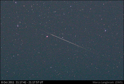
16 Draconid meteors photographed between 19:27 and 21:18 UTC, 8 October 2011. Canon EOS 450D + EF 2.0/35mm, 800 ISO, Dunkelsdorf, Germany. Photo by author.
In the evening of October 8-9 2011, the Draconid meteor shower performed a rare meteor outburst. In normal years, hardly any Draconid meteors can be seen. But in 1933, 1946, 1952, 1985 and 1998, short but (very, in the cases of 1933 and 1946) intense outburst were observed. The earth crossed through dust trails left by the parent comet 21P Giacobini-Zinner those years. Zenith Hourly Rates were in the several hundreds in 1985 and 1998, in the thousands in 1933 and 1946.

Last October 8th (2011), the earth was predicted to encounter a dust trail left by the comet in 1900. Predictions for the activity varied, from virtually nil to several hundreds/hour, depending on the modeller and model (see summary in sidebar here).

Several scientific efforts were set up to monitor the event. I joined one of them, a joint effort lead by Peter Jenniskens (SETI/NASA-Ames) in cooperation with the Leibniz-Institut für Atmosphärenphysik (IAP) in Kühlungsborn, Germany (Michael Gerding), and Carl Johannink and me from the Dutch Meteor Society (DMS). Our project was a groundbased part of a wider effort including two aircraft flying with scientific equipment (the Draconid 2011 Multi-Instrument Aircraft Campaign, see here).


Our goal was to do observations that could not be easily done from the aircraft: determine 3D trajectories of meteors in the atmosphere by triangulation of images taken from two locations, in combination with an attempt to detect debris/ionization trails of these same meteors using a LiDAR.

The LiDAR in question, was the LiDAR of the Leibniz-Institut für Atmosphärenphysik (IAP) in Kühlungsborn, a small bathing resort at the Baltic coast of eastern Germany. This part of the observations was done by Dr Michael Gerding of the IAP, who was also our host during the effort. Peter Jenniskens, Carl Johannink and me would employ and operate the multistation video network, using the CAMS system build by Peter and his team at SETI/NASA-Ames (the CAMS project is part of NASA's Planetary Astronomy program).


click images to enlarge
The CAMS systems (4 low-light level video cameras per station) used. Top: the setup at Lebatz station operated by Carl Johannink and the author (DMS). Bottom: the setup at the IAP Kühlungsborn station operated by Peter Jenniskens (left; SETI/NASA-Ames) and Michael Gerding (right, IAP).
Wednesday 5 October

I fetched Peter Jenniskens from Schiphol airport near Amsterdam on Wednesday the 5th. We hauled his equipment (two heavy metal cases, apart from Peter and mine personal luggage) into the train to Enschede in the eastern Netherlands, where Carl fetched us and drove us the few remaining kilometers to Gronau, just over the Dutch-German border. This was our first base-station. The weather prospects were still very uncertain at that time. Peter wanted to press on with the plan to go to Kühlungsborn (because of the LiDAR). Carl and I were less certain: southern Europe had the best papers in terms of clear sky prospects at that moment.

Thursday 6 October

Weather predictions now suggested Northern Germany (where Kühlungsborn is situated) could benefit from a zone of clear air created over Denmark and Sleswig-Holstein in northern Germany in the "shadow" of the Norwegian mountains. It was settled that we would try Kühlungsborn. The early part of the day was spent running various errands. More seriously, one of the PC systems operating CAMS had a malfunction and Peter was not able to solve it. We left in the afternoon, driving several hundreds of kilometers to Kühlungsborn, where Michael Gerding of the IAP welcomed us near 22h local time after a long exhausting drive.

Friday October 7

This day, we set up shop in the LiDAR control room of the IAP, which was to become our headquarters for the campaign. An IT specialist of the IAP was brought in to solve the PC trouble - eventually, he managed to find what was wrong and got everything operating again! Meanwhile, we had gotten a sightseeing tour of the IAP facilities. It is a beautiful, modern institute and the guest lodging in town where Michael put us up for the night was very fine. Kühlungsborn itself is a small cozy town, a bathing resort on the Baltic coast in the former Eastern Germany. Peter held a lecture before the institute members, Carl and I made a small beachwalk that afternoon.


click images to enlarge
The LiDAR control room at the IAP became our headquarters. Top: Peter (right) and Carl (left) with the CAMS systems. Bottom: checking the weather predictions and plotting potential locations for our second station (left Peter, middle Carl, right our host Michael)

That evening was a test evening for the LiDAR, to see whether anything needed trouble-shooting. There actually was a problem initially with the LiDAR, but it was solved and didn't hamper the actual observations the next night.


click images to enlarge
the IAP Kühlungsborn LiDAR at work during a test run a day before the actual observing night. Second image shows the beam hitting a low cloud. Photograph by author using an 8mm semi-fisheye.
Seeing the massive laser beam of the LiDAR shooting up into the sky was quite impressive. Meanwhile, the weather was still very dynamic, so we worried about the next night, when all had to happen.

Saturday, October 8th

Based on the latets weather forecasts, we picked a location 91 km to the west for our second site, right in the middle of the projected clear area in the weather forecast. Carl and I would run it, and so we drove away at noon, to the small village of Lebatz (53 deg 58' N, 10 deg 35' E) in Sleswig Holstein, about 30 km north of Lübeck. We had picked a small hotel from the internet there. The hotel owner was a bit surprised by our demand for a room "with a view to the north east". We needed the latter, as the mutual aiming point we had calculated for the Kühlungsborn and Lebatz CAMS systems meant we had to point at 46 degrees elevation to the northeast. Peter at Kühlungsborn filmed 15 degrees north of the Zenith, just north of the LiDAR beams. In that way, we would film the same meteors from both stations, appearing at 95 km altitude over the Baltic sea just north of Kühlungsborn: meteors whose ionization trails next would drift into the LiDAR beams, as a result of a high altitude wind blowing from the north-northeast at 95 km altitude.
Meanwhile, two other Dutch observers, Peter van Leuteren and Sietse Dijkstra, had joined us: they had driven to Lebatz from the eastern Netherlands that same day, arriving about an hour after us.

Just before our car turned into Lebatz (which, by the way, turned out to be one of the rare spots in NW Europe without cellphone coverage), I had noted a small roadsign saying: 'Dunkelsdorf, 1 km'. 'Dunkelsdorf' means "dark village" in German. So naturally, that name appealed to us! After setting up shop in the hotel in Lebatz (our CAMS system would run from the open hotel window, as we needed electric power and a dry place for the PC), we drove the 2 km to Dunkelsdorf, and found a nice hiltop with 360 degrees view. The farmer was working nearby, and gave us permission to use the field that night (he turned out to be an astronomy enthusiast himself).


click image to enlarge
Our observing spot (bottom) near Dunkelsdorf, photographed the morning after

After a good meal in the small tavern at the hotel, Peter v. L. and Sietse left for the observing field at dusk. The sky was clearing at that moment, witha few remnant fields of clouds. This looked very promising for the night! Carl and I stayed at the hotel waiting for the sky to become dark enough to aim and focus the cameras. That took some effort, also because we were not used to this new equipment. But with some trial and error, we managed to get the whole system running: and after the cameras are aimed, and focussed well, the PC takes over and the whole system runs automatically, and we could leave for the field. Neat!

So after setting up, aiming, focussing and initiating the camera systems, Carl and I drove to the observing field as well, arriving there at 20:30 local time. Sietze and Peter v. L. already had seen some bright Draconids, they reported as we arrived. We set up our gear (field bed, sleeping bag, handheld memorecorders, and in my case a tripod with my photo camera) and joined the observations. The last cumulus clouds were moving out of the sky and it became brilliantly clear. Observing due North away from the moon, I determined a limiting magnitude of +6.3 in Draco to my (and my fellow observer's) astonishment, with the milky way visible into Perseus. This was wonderful, I have never experienced such a good sky with moonlight before! Directly in the minutes after I started observing, the first Draconids were seen. So there was activity, at least! Would it lead to a peak near 20h UTC (22h local time)?

Observing the activity peak

It did indeed lead up to a peak just after 22h local time. More and more meteors appeared, shooting away from a radiant in the head of Draco. Around 20 UTC, I counted 3-4 Draconid meteors per minute. Most were rather faint, so we wondered what we would have seen without the moon.... Nevertheless, even in a moonlit sky, the show was impressive, and it was clear the Zenith Hourly Rates must be in the hundreds. We were excited!

We were also worried. Low in the east, below 5 degrees elevation, we could see persistent clouds. That was where our other station was, Kühlungsborn with Peter, Michael and the LiDAR..... Telephonic contact (our cell phone did have coverage from the hilltop) revealed that they had a lot of clouds, but also clear periods.

click diagram to enlarge
ZHR diagram of my observations, suggesting a peak ZHR near 250 just after 20 UTC


My observations suggest that the ZHR at the peak was in the order of 250. This is just an indication, as it are observations with moonlight, from one observer. In total, I observed 248 Draconid meteors in 2.77h effective observing time.


My photo camera with EF 2.0/35mm lens captured 16 Draconids (image above) in slightly less than two hours time: most meteors were simply too faint to be photographed. Our video camera's meanwhile, sensitive to much fainter meteors, filmed hundreds of meteors.

Some meteors left persistent trains. It are these trains of course, that were the target for the LiDAR. Below animated GIF shows a bright Draconid I photographed, with traces of a dissipating persistent trail drifting on the wind in several images obtained after it appeared:


The short movie shows the trail drifting from bottom right to upper left in about 2 minutes time: indeed consistent with a high altitude wind direction from the NE to SW.

After 22h local time (20h UT), activity was on the decline again. The peak was over. Around midnight, we stopped our observations (the CAMS system would run untill 1 am). It was still brilliantly clear: we couldn't have been in a better spot!


click image to enlarge
Four happy observers the morning after the outburst observations. From left to right: Carl Johannink, Peter van Leuteren, Sietse Dijkstra, and the author

Kühlungsborn

The next day, Peter van Leuteren and Sietse drove back to the Netherlands, and Carl and I drove back to Kühlungsborn. Ariving there near 11 am, we heard the story of Peter and Michael. They had a lot of clouds, but luckily also a largely clear period of about an hour around the peak time. This increased our hopes to have filmed at least a few meteors multistation, hopefully with a LiDAR detection as well.

With the data reduced we can now say we filmed at least 34 Draconids plus two sporadic meteors from both stations, yielding accurate atmospheric trajectories, lightcurves, and orbits in the solar system. The LiDAR did have detections as well, but work to correlate these with meteors filmed by us is still in progress. If we do have LiDAR detections that we can correlate with meteors we filmed (more precisely: with the atmospheric trajectories and lightcurves that our multistation filming produced), that will yield a lot of information about processes happening in the upper atmosphere because of these meteors.

Below is a compilation of video meteors filmed by three of the Lebatz cameras and one of the Kühlungsborn cameras. The latter images also shows the LiDAR beams (and clouds, unfortunately). Draconid meteors are moving from top to bottom, everything from another direction is an aircraft, satellite, or sporadic meteor.


It was ten years ago that I last had been involved in such a scientific meteor observing effort - I participated in several of the Leonid meteor outburst scientific campaigns in the 1990-ies. It was exciting to get involved again for the Draconids.

note: I want to warmly thank the people of the IAP and especially Dr Michael Gerding for housing us during the campaign.

Saturday 15 October 2011

Another ROSAT observation

Yesterday evening was clear, and I again observed the doomed satellite ROSAT (see my previous post), in deep twilight (sun at -6 degrees). It was again bright, magnitude +1, very fast, easy to see even though the sky was still bright blue with only a few stars visible. Like my earlier observation the day before yesterday, it was steady in brightness, with no sign of brightness variations, suggesting it is not tumbling.

Photographically it was a challenge: I had to do some serious image editing tricks to pull the trail out of the bright twilight background on the image below (on the unedited image, the trail is visible but very inconspicuous):

click image to enlarge

These high elevation (near 70 degrees) twilight passes are quickly moving  earlier (and too early) in the evening for me: yesterday's was the last one I could expect to realistically observe. Passes at lower elevation (12-14 degrees) in late twilight will become visible for me after tomorrow and might allow me to observe it for a few more days later this week, until these passes move too early as well.

Using Alan Pickup's SatEvo software and the current 10.7cm solar flux, I get a projected decay at October 23. Harro Zimmer, using another model, gets October 24th. These predictions still have an uncertainty of a few days, so expect them to shift over the coming days, amongst others due to changing solar activity.

Thursday 13 October 2011

Observing another doomed satellite: ROSAT

Shortly after the UARS reentry, which got wide attention, another scientific satellite is about to meet its demise by an uncontrolled plunge into the atmosphere. It is the German X-ray astronomical satellite ROSAT. This satellite is currently predicted to reenter about October 22 to 24.

This evening I watched it pass during twilight (sun at 8 degrees below the horizon, first stars just visible in a blue sky). It was fast, zipping across the sky, and bright: magnitude +1 and an easy naked eye object.

I used the new EF 2.0/35mm lens (a new purchase, first used last weekend during the Draconid meteor outburst, on which I will post in a later post), set to F2.5, making 5 second exposures at 400 ISO. The fast moving objects ran out of the frame of two of the three images. Below is the image thats shows the complete trail. The satellite was moving from left to right, across Cepheus. The streak in top is a streak of cirrus.

click image to enlarge


Sunday 2 October 2011

Back to business - KH-12 USA 129, the STSS demo's and more

The focus on the UARS decay the past two weeks will not have escaped the frequent readers of this blog. It is now time to leave UARS to rest, and turn back to business as usual .

The past week saw warm and sunny weather. I managed to observe on 27, 28 and 29 September as well as October 1st.

The KH-12 keyhole USA 129 (96-072A) was one of the major targets. Both on the 28th and 29th it flared to mag. +0.5, at 20:17:04.8 (28 Sep) resp. 20:21:04.0 (29 sep) UTC.

On the 29th, the images of USA 129 showed a Breeze-M tank, 04-031C, as a stray:

click image to enlarge


These pieces of Russian space debris pop up more often on my images lately. They are the jettisonable torroidal (doughnut-shaped) fuel tanks of a Breeze-M, the upper stage of a Proton M. There are now over 40 of these spent empty tanks in space, often in highly elliptic orbits representative of a geostationary transfer. Even at considerable distance, they are bright. During perigee passes, they zip through the sky at high speed as bright naked-eye objects. Further out, they move slow but are still relatively bright, as visible on the image above.

The Breeze-M tank above was at a range of over 2700 km (by contrast, USA 129 was at a range of 948 km) at the time of photography, and is a leftover from the 2004 launch of the South American geostationary communication satellite AMAZONAS.

On that same night of September 29th, I used the Samyang 1.4/85mm to target, two of the Space Tracking and Surveillance System (STSS) satellites, STSS Demo 1 and Demo 2. (09-052A & B). Both these faint satellites were captured near their apogee at approximately 1359 km altitude.

click images to enlarge


Other satellites photographed these nights were the Trumpet ELINT and  SBIRS low satellites USA 184 (06-027A) and USA 200 (08-010A), two satellites in HEO.

In addition, I used the 61 cm telescope of SSON in California to photograph the enigmatic Prowler again (see also my previous post here for backgrounds on this highly classified satellite).

On September 30th, I was too tired to do serious observations. I however set up the camera with 24 mm lens and automated timer to redo my recent classic startrails circling the celestial pole image, but this time for a total exposure time of 3 hours 20 minutes:

click image to enlarge