Monday 27 May 2024

Gazing in my crystal ball: at what time will North Korea launch Malligyong-2? [UPDATED]

click to enlarge


I have been gazing in my crystal ball to come up with an educated guess of the launch time (and with that, the possible orbit) of Malligyong-2, the upcoming North Korean satellite launch (see previous post).

The Navigational Warnings for the launch are similar to those for Malligyong-1 (2023-179A, (see previous post), which was launched on 21 November 2023 and is orbiting in a sun-synchronous morning orbital plane. So it is likely that Malligyong-2 goes into a similar 97.4 degree inclined, 512 x 493 km sun-synchronous orbit.

It would make sense however if  Malligyong-2 would not be launched into the same orbital plane in terms of RAAN, but rather target a complementary orbital plane. [but:see update below...]

The Malligyong-1 orbital plane is currently making daytime passes over Pyongyang around 10:13 local Pyongyang time. It is a morning plane (meaning: daytime passes in the local morning, near 10 am).

Two options are then in order for Malligyong-2: one is launch into an afternoon plane complementary to the Malligyong-1 morning plane (i.e. resulting in passes with a  similar solar elevation but in the afternoon, mirroring the morning passes). The other is launch into a noon plane, roughly inbetween the two.

The image above depicts the afternoon variant relative to the Malligyong-1 orbit. The noon plane is the mid-line of the globe.

Assuming launch on May 28, the afternoon plane option would mean launch around 5:37 UTC (14:37 local Pyongyang time) and this resulting approximate orbit:

MALLIGYONG-2                  for launch on 28 May 2024  05:37:00 UTC
1 70000U 24999A   24149.67289979  .00008068  00000-0  36481-3 0    07
2 70000  97.4276 275.3747 0014260 279.3296  80.6327 15.21105052    08

Of course this remains speculation, fueled by my OCD desire for neat constellations...

We'll see when launch happens (and if it is successful).


UPDATE: 

Launch actually appears to have been May 27, 14:50 ~13:45UTC, and failed. I guess my crystal ball is over its expiration date....
The time of launch is actually consistent with launch into the same RAAN plane as Malligyong-1.

UPDATE 2:

The North Korean State Press Agency KCNA calls the satellite in the failed launch "Malligyong-1-1" and indicates first stage failure caused the mishap, related to the "reliability" of a new LOX + petroleum engine. The wording is somewhat ambiguous on whether it concerns a new kind of rocket or a Chollima-1 stage: they do not name the rocket type, but mention a "new-type satellite carrier rocket".


It should be noted that during the previous Malligyong-1 launch, the Chollima-1 first stage also blew up, somewhat after separation of teh second stage (so it did no harm to the payload at the time). Here is footage of that occasion.

Sunday 26 May 2024

New North Korean launch (Malligyong-2) upcoming [UPDATED]

click map to enlarge

Navigational Warnings (HYDROPAC 1800/24) have appeared for a new North Korean satellite launch, the launch of their second military reconnaissance satellite Malligyong-2, from Sohae. North Korea also informed the Government of Japan of the upcoming launch.

The three hazard areas A to C  from the Navigational Warning are the same as those for the Malligyong-1 launch half a year ago (21 November 2023 - see this earlier blogpost). Quite likely therefore, the launch will go into a similar 97.4 degree inclined, 512 x 493 km Sun-synchronous orbit. Stage 2 and stage 3 will do a double dogleg.The launch window runs to June 3.

It will be interesting to see what the RAAN of the orbital plane will be in relation to that of Malligyong-1.

This is the text of the Navigational Warning:

261806Z MAY 24
HYDROPAC 1800/24(GEN).
PHILIPPINE SEA.
YELLOW SEA.
CHINA.
DNC 11, DNC 23.
1. HAZARDOUS OPERATIONS, ROCKET LAUNCHING
   IN PROGRESS UNTIL 031500Z JUN
   IN AREAS BOUND BY:
   A. 36-06.93N 123-33.12E, 35-24.52N 123-22.78E,
      35-20.02N 123-48.62E, 36-02.43N 123-59.18E.
   B. 34-05.90N 123-01.98E, 33-23.47N 122-51.88E,
      33-16.53N 123-29.67E, 33-58.97N 123-40.07E.
   C. 14-54.17N 128-40.10E, 11-19.30N 129-10.83E,
      11-26.82N 129-54.13E, 15-01.70N 129-24.05E.
2. CANCEL THIS MSG 030600Z JUN 24.

UPDATE: further speculation as to what could be the launch time in a follow-up post here.

UPDATE 2:  launch was near 13:50 UTC (May 27, 2024) and failed due to in-flight explosion of the first stage.

UPDATE 3: The North Korean State Press Agency KCNA calls the satellite in the failed launch "Malligyong-1-1" and indicates first stage failure caused the mishap, related to the "reliability" of a new LOX + petroleum engine. The wording is somewhat ambiguous on whether it concerns a new kind of rocket or a Chollima-1 stage: they do not name the rocket type, but mention a "new-type satellite carrier rocket" . 


It should be noted that during the previous Malligyong-1 launch, the Chollima-1 first stage also blew up, somewhat after separation of the second stage (so it did no harm to the payload at the time). Here is footage of that occasion.

The NROL-146 payloads: observing the 'train' of 21 Starshield satellites

On May 22, 2024, at 08:00:20 UTC, SpaceX launched a Falcon 9 from Vandenberg SLC-4 as NROL-146, carrying 21 classified payloads for the NRO.

It is the first operational launch of a 'proliferated architecture' (meaning: launching a lot of the same payloads, creating redundancy and with that less vulnerability to failure or countermeasures). The mission motto was: 'Strength in Numbers'.

Based on previous SDA Tranche 0 launches, I initially guessed that they would go in a ~900 km orbit. But on May 22 near 23:08 UTC, Spanish meteor cameras operated by the SPMN recorded a Starlink 'train' like phenomena low in the northern sky, with the 'train' entering Earth shadow around 23:08:10 UTC. I identified it as likely NROL-146, as the orbital plane would indeed pass over southern Europe around the time of observation. Time of observation and shadow entry itself however suggested a much lower orbital altitude, near 300 km, than my initial estimate.

The next two days I was clouded out, but yesterday evening (25-26 May), the sky finally cleared. Just after local midnight, I observed the 'train' from Leiden, counting 21 objects that passed over a 4-5 minute timespan. The 4-minute video above shows all 21 objects. They were very bright (magnitude +2 to +3).

If you get a 'Starlink'-vibe from the video, that is because they basically are. Built by SpaceX and Northrop Grumman, "Starshield" is a military version of Starlink, likely built on the same type of bus. 

Observations so far suggest they were launched into a ~310 km, 69.7 degree inclined orbit. Over the coming days and weeks they will disperse along their orbital plane, and likely also raise their orbital altitude.


click to enlarge

Below is a very cautious elset for the leading object:


NROL-146 obj A                                           310 x 311 km
1 70006U 24999A   24146.90436495 0.00000000  00000-0  00000+0 0    05
2 70006  69.7199  66.3577 0000678 155.5007 204.6228 15.87074186    05

Monday 20 May 2024

The Russian KOSMOS 2576 launch of May 16, and USA 314: another 'inspector satellite'? [UPDATED]

click to enlarge


 (this blogpost reflects discussions with and information provided by Bart Hendrickx, Bob Christy and Jonathan McDowell)

In a previous blogpost I wrote about a Russian launch into SSO from Plesetsk on May 16. According to Roscosmos, the launch was at 21:21:29 UTC.

Based on the Sun-Synchronous orbit indicated by the launch azimuth I initially suspected this to be a new IMINT mission, but now I am not so sure

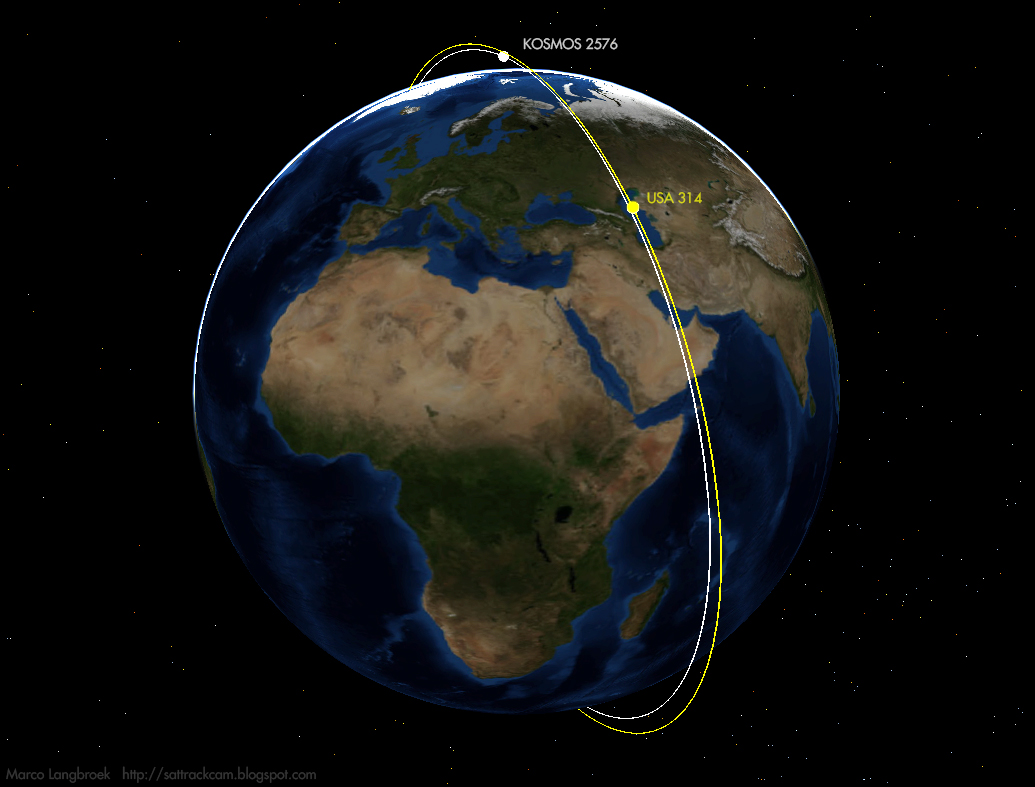
IMINT is part of it, but not all, and the primary payload, KOSMOS 2576, might actually be another inspector satellite, this time targetting the American KH-11 ADVANCED CRYSTAL spy satellite USA 314 (2021-032A), as suggested by Bob Christy.

The launch inserted at least 9 objects into space (2024-092A to J), and possibly more: all in basically the same orbital plane (with small subgroups), but at different orbital altitudes. Based on the nine objects catalogued so far (status 20 May 2024), four groups can be discerned, based on orbital period and inclination:

GROUP     ORBIT (km)  INC     PERIOD   OBJECT(S) possible ID
I         451 x 435   97.25   93.45    A         KOSMOS 2576
II        796 x 780   98.59   100.62   G,H,J     Rassvet
IIIa      552 x 532   97.59   95.52    D,E,F,K   SITRO-AIS
IIIb      548 x 531   97.59   95.45    B,C       Zorkiy 2M

As expected, Roscosmos has announced the primary military payload to be designated KOSMOS 2576. It is likely object A (see below) that stands out as a lone object in orbital altitude and inclination. 

Also part of this launch, according to sources, are three civilian Rassvet satellites that provide high speed internet connectivity; and (as announced by Sputnix) two civil Zorkiy 2M earth observation satellites, and four civil SITRO-AIS satellites (the latter six all cubesats). This means that at least one satellite has not been catalogued yet, if these numbers are correct. [edit: this fourth satellite has now also been catalogued, as object K]

To make it even more complex, some analysts believed the launch to have included three military Razbeg Optical reconnaissance satellites as well. But this now seems less likely.

The orbital plane that the primary payload, Kosmos 2576 was launched into, might not be random. As was first pointed out by Bob Christy, the orbital plane closely matches that of the American KH-11 ADVANCED CRYSTAL spy satellite USA 314 (2021-032A).

In the past, we have seen this happen before. In August 2022, Kosmos 2558 was inserted into the orbital plane of the American KH-11 spy satellite  USA 326 (see this earlier blogpost), making close approaches each 5 days. Earlier, in 2020, Kosmos 2542 and its spawn Kosmos 2543 were inserted into the orbital plane of the American KH-11 spy satellite USA 245, also making close approaches.

Object A, the primary candidate for Kosmos 2576, differs in RAAN with USA 314 by only 0.02 degrees, and in inclination by only 0.8 degrees. Its current orbital altitude (451 x 436 km) is lower than that of USA 314 (769 x 548 km), but both orbital altitude and inclination are the same as that of a previous 'inspector satellite', Kosmos 2558 (see earlier blogpost). Object A might raise its orbit in the future or, like Kosmos 2542 did in 2020, spawn a second satellite that moves upwards in orbit. It will be interesting to see what object A will or will not do in the near future.


click to enlarge

The reason to see the lone group I object, object A as the primary payload (Kosmos 2576) is the following: 

First, as already mentioned, its orbital plane closely matched that of USA 314, and as Bob Christy noted,  its orbit in terms of altitude and inclination closely matches that of a previous 'inspector satellite' that targetted a US KH-11 satellite, Kosmos 2558

Second: when propagated backwards to the time of launch, the object is placed close to Plesetsk; and its orbital plane passes right over the stage deorbit area from Navigational Warning NAVAREA XII 330/24 in the Pacific Ocean (see map below, and see also previous post for maps and discussion), related to the initial launch phase. This indicates that object A is the primary payload and the first of the objects to be released into orbit. 

click m ap to enlarge
 

By contrast, the three group II objects (G, H, J) at ~780 km do not match the deorbit area in the Pacific well at all (as can be seen in the map above), and back-propagated to the launch time they do not come out near Plesetsk. This indicates manoeuvers before their orbit insertion.

The orbital insertion sequence of the various objects from this launch was probably as follows:

(1) launch into 97.24 inclined, 435 x 451 km orbit, insertion of object A (primary payload);
(2) manoeuver up into 98.59 inclined, 780 x 796 km orbit, insertion of objects G,H,J (secondary payloads);
(3) manoever down into 97.59 inclined, 535 x 552 km orbit, insertion of objects D,E,F,K;
(4) slightly lower apogee, no inclination change, 531 x 548 km orbit, insertion of objects B,C;
(5) Fregat stage deorbit reentry ~10h 20m after launch.

The reasoning behind this sequence is the following:

In addition to the Navigational Warnings which I discussed above and in a previous post, Bob Christy found a NOTAM in the Indian Ocean which is likely for the Fregat stage deorbit, with a time window starting some 10 hours after launch (suggesting a prolonged coast phase and/or multiple manoeuvers):

F1791/24 NOTAMN
Q) YMMM/QWMLW/IV/BO/W/000/999/2815S07736E500
A) YMMM
B) 2405170700 C) 2405220900
D) DAILY 0700-0900
E) ROCKET LAUNCH FROM RUSSIA WILL TAKE PLACE
FLW RECEIVED FROM GOVERNMENT OF RUSSIA:
THE MINISTRY OF DEFENSE OF RUSSIA PLANS TO LAUNCH MISSILE IN THE
SPACE AND TO SINK ITS FRAGMENTS IN THE WATERS OF THE OCEAN.
CHARACTERISTICS OF IMPACT AREA:
3521S07521E
2100S07900E
2109S07936E
3530S07603E
3521S07521E
F) SFC G) UNL
CREATED: 14 May 2024 12:33:00
SOURCE: YBBBZEZX


The orbital plane of the group III objects (see table earlier in this post) B, C, D, E,  F and K passes over this area, 10h 20m after launch (i.e. near 7:40 UTC, May 17).This could indicate that these objects were the last to be released, before deorbit of the Fregat stage. The orbital planes of group I and II do not match this deorbit area that well, passing somewhat east and west of it. 

click map to enlarge
 

This leaves group II objects G, H J, the ones in the highest orbit (~780 km), whose orbital plane matches neither the Pacific Ocean nor Indian Ocean deorbit areas particularly well. This indicates manoeuvers both before and after their release, suggesting their orbital insertion was between that of group I and group III.

As to the possible identities of the objects from group II, IIIa and IIIb:

The orbital inclination and period (95.45 minutes and 97.6 degrees) of the two group IIIb objects (B, C) match those of two objects (2024-092B and C) from a previous launch that included Zorkiy 2M satellites. So objects B and C of the current launch are probably the two Zorkiy 2M payloads.

The orbital inclination and period  (95.52 minutes and 97.6 degrees) of the three group IIIa objects (D, E, F, K) match those of both earlier Rassvet and SITRO-AIS launches, but their number matches the number of SITRO-AIS payloads announced in this launch.

The three group II objects (G, H, J) in the higher ~780 km orbit match neither previous Rassvet, SITRO-AIS or Zorkiy 2M launches. But by a process of ellimination they must be the three Rassvet payloads announced - if there are no other objects catalogued in the future.

The picture presented here might be revised if more objects are catalogued. For now, this is my best interpretation. It will be particularly interesting to see what object A will do.


UPDATE 22 May 2024:

US United Nations ambassadeur Robert Wood has, in a May 20 UN Security Council debate, accused Russia of launching a 'counterspace weapon' into Low earth Orbit on May 16. The claim was later repeated, including a mention of it being in "the same orbit" as a US Government satellite, by Pentagon spokesman Brig. General Pat Ryder.

This clearly refers to Kosmos 2576 (object A) - the US military evidently also thinks the co-orbital character of Kosmos 2576 with USA 314 is no coincidence

Russia flatly dismisses the suggestion, calling it "fake news".

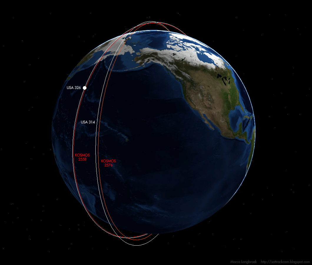
Currently, there are two Russian satellites in LEO that are suspiciously co-planar with an American KH-11 ADVANCED CRYSTAL electro-optical reconnaissance satellite: Kosmos 2558 (2022-089A) co-planar with USA 326 (2022-009A); and now Kosmos 2576 (2024-092A) co-planar with USA 314 (2021-032A). Kosmos 2558 currently makes approaches to ~50 km to USA 326 each 7 days.

click image to enlarge

For those who want to compare, here are two recent orbits for USA 314 and USA 326 based on amateur tracking data:

USA 314
1 48247U 21032A   24141.96990730 0.00002000  00000-0  27073-3 0    05
2 48247  98.0438 254.1015 0157205 111.3087 248.6912 14.70745533    09
USA 326
1 51445U 22009A   24141.98253796 0.00017500  00000-0  79138-3 0    00
2 51445  97.4250 239.7279 0011614 145.1315 214.8683 15.20909891    06

Sunday 19 May 2024

Upcoming test of a Conventional Prompt Strike (CPS) hypersonic missile

click map to enlarge

A Navigational Warning has appeared that points to a US missile test conducted west of Hawaii in the period May 23 - 25, 2024, 21:30-0300 UTC

The shape of the hazard zones is similar to that of the (failed) June 2022 JFC-1 Conventional Prompt Strike (CPS) test, which is part of a US Navy program for a submarine-launched MRBM with a hypersonic glider as reentry vehicle. The program has ties with the US Army LHRW hypersonic missile program discussed on this blog a few times.

The range indicated by this test is about 3500 km.

The Navigational Warning (also issued as NAVAREA XII 358/24):

281825Z APR 24
HYDROPAC 1689/24(19,81).
NORTH PACIFIC.
HAWAII.
DNC 12, DNC 13.
1. MISSILE OPERATIONS 2130Z T0 0300Z DAILY
   23 THRU 25 MAY IN AREAS BOUND BY:
   A. 23-00.00N 180-00.00E, 23-00.00N 175-00.00E,
      23-00.00N 170-00.00E, 23-45.00N 165-00.00E,
      22-30.00N 165-00.00E, 21-30.00N 170-00.00E,
      20-45.00N 175-00.00E, 20-00.00N 180-00.00E.
   B. 22-01.00N 159-47.00W, 22-03.00N 159-45.00W,
      22-04.00N 159-45.00W, 22-30.00N 160-00.00W,
      22-45.00N 161-00.00W, 23-00.00N 165-00.00W,
      23-45.00N 170-00.00W, 23-45.00N 175-00.00W,
      23-00.00N 180-00.00W, 20-00.00N 180-00.00W,
      20-00.00N 174-00.00W, 20-45.00N 170-00.00W,
      21-15.00N 165-00.00W, 21-30.00N 161-00.00W,
      21-51.00N 160-00.00W.
2. CANCEL THIS MSG 260400Z MAY 24.

Launch is probably from a TEL located at the Pacific Missile Range Facility at Barking Sands, Kauai.

Wednesday 15 May 2024

A Russian Optical Reconnaissance satellite launch from Plesetsk upcoming [UPDATED TWICE]

click map to enlarge


(two updates at bottom of post)

Navigational Warnings have appeared that point to a Russian launch from Plesetsk between May 16-26. The direction of launch as indicated by the hazard zones from the Navigational Warnings (see maps above and below), points to launch into a ~97.75 degree inclined Sun-synchronous orbit. This, in turn, points to an IMINT mission, i.e. an optical reconnaissance satellite.

There are two options: another BARS M satellite (BARS M6), or something new. There are indications of the latter. Compared to previous BARS M launches, in addition to hazard zones near the Kola peninsula and Svalbard, there is an extra deorbit zone, in the NE Pacific some 1100 km out of the coast of California. As Bart Hendrickx pointed out, this might indicate the addition of a Fregat upper stage to a Soyuz 2 rocket, something not seen before for launches into SSO from Plesetsk.

Bart Hendrickx thinks it might perhaps concern a launch of three small Razbeg optical reconnaissance satellites.


click map to enlarge


Launch window as indicated by the Navigational Warnings is May 16-26, 20:00-23:00 UTC daily. These are the relevant Navigational Warnings (which are plotted in the maps above):


NAVAREA XX 062/24
BARENTS SEA.
CHART RUS 10100.
1. ROCKET LAUNCHING 2000 TO 2300 UTC
DAILY 16 TO 26 MAY NAVIGATION
PROHIBITED IN TERRITORIAL WATERS
DANGEROUS OUTSIDE IN AREA BOUNDED BY:
70-56-00N 032-04-58E, 70-10-00N 033-40-00E,
69-54-00N 032-40-00E, 70-08-00N 032-04-58E,
70-15-00N 031-50-00E, 70-30-07N 031-50-00E,
70-36-22N 031-43-18E.


111952Z MAY 24
HYDROARC 75/24(42,43).
BARENTS SEA.
SVALBARD.
DNC 22.
1. HAZARDOUS OPERATIONS, SPACE DEBRIS
   2000Z TO 2300Z DAILY 16 THRU 26 MAY
   IN AREA BOUND BY
   76-30.00N 022-00.00E, 75-20.00N 024-40.00E,
   74-50.00N 021-40.00E, 75-50.00N 018-40.00E.
2. CANCEL THIS MSG 270001Z MAY 24.


120900Z MAY 24
NAVAREA XII 330/24(18).
EASTERN NORTH PACIFIC.
1. HAZARDOUS OPERATIONS, SPACE DEBRIS
   2000Z TO 2300Z DAILY 16 THRU 26 MAY
   IN AREA BOUND BY
   29-21.00N 126-46.00W, 29-50.00N 128-52.00W,
   24-22.00N 130-24.00W, 23-53.00N 128-15.00W.
2. CANCEL THIS MSG 270001Z MAY 24.


Assuming an orbital altitude at ~500 km, this is an approximate orbit guess for launch at the start of the window (the orbital inclination could be off by a few tenths of a degree, and orbital altitude is a guess only):

Russian IMINT                  for launch on 16 May 2024 20:00:00 UTC
1 70000U 24999A   24137.83333333  .00000000  00000-0  00000-0 0    09
2 70000 097.7500 232.3966 0010908 075.7763 325.4205 15.22766913    04


UPDATE 1, 17 May 2024:

The launch was at 21:21 UTC (May 16). One single payload (59773, 2024-092A) has so far been catalogued, in a 97.25 degree inclined, 451 x 436 km sun-synchronous orbit. So my pre-launch orbit estimate above was off by 0.5 degrees in inclination and ~50 km in orbital altitude [but: see second update below].

The payload will likely get the designation Kosmos 2576. The orbital altitude is some 53.5 km lower than the typical orbit of a BARS M satellite, indeed suggesting this might be something new. The orbit also doesn't fit well into the existing BARS M constellation


KOSMOS 2576 (yellow) compared to BARS M constellation (white)

UPDATE 2, 19 May 2024:

8 additional objects have now been catalogued (59774 to 59781), making a total of 9. They fall in three/four groups:

GROUP     ORBIT       INC     PERIOD   OBJECTS
I         451 x 435   97.25   93.45    A
II        796 x 780   98.59   100.62   G,H,J
IIIa      552 x 532   97.59   95.52    D,E,F
IIIb      548 x 531   97.59   95.45    B,C

More in a follow-up post, as there might be something more to these orbits....

click to enlarge

A glimpse of the ACS 3 Solar Sail bus

Artist impression of ACS3 once the sail is deployed (image: NASA)


On 23 March 2024, Rocket Lab launched the Advanced Composite Solar Sail System (ACS3), a NASA solar sail experiment. The main goal of the mission is to test the deployment of a 80 m2 (9 x 9 meter) solar sail from a 12U cubesat bus. The sail will be deployed late May or early June 2024, i.e. some 2 months after the launch. ACS3 (2024-077B) is in a 97.4 deg inclined, 993 x 1023 km sun-synchronous orbit.


The 9 x 9 meter ACS3 sail (image: NASA)

ACS3 orbit

On 3 May 2024, I managed to image the 12U ACS3 bus, using a WATEC 902H2 Supreme camera and Samyang 1.2/85 mm lens. Below is a frame stack of 102 video frames. The faint streak at lower right is the 12U ACS3 bus, which was at a range of 1118 km at the time. It reached magnitude +9.3, but I think I captured it during a glint, as it was visible for a few seconds only.


As the solar sail has not yet been deployed, this detection is the 12U bus (i.e. a bus of 30 x 20 x 20 cm) only, seen here during assembly:


the 12U bus (image: AST & Defense)

It will be interesting to see what brightness the object will reach once the big solar sail has been deployed. It could potentially get quite bright. I have good memories of a similar mission (but at lower altitude, and with a smaller sail surface), Nanosail-D2, from 2011 (see for example this 2011 blogpost).

The mission is sending telemetry at 401.5 MHz. Here is a radio detection from my station at Leiden from 6 May 2024:

click image to enlarge

A more elaborate overview of the ACS3 mission and goals can be read here.

Sunday 12 May 2024

OT: The beautiful Aurora of May 10, 2024

click to enlarge

 (more imagery below the text)

On May 10, 2024, the strongest Solar storm in 20 years hit Earth. As a result, Aurora borealis (Northen Lights) was visible at much lower latitides than normally, including the Netherlands, where it put on a splendid, bright, colorful display between midnight and 1 am of the night of May 10-11.

Looking at the geomagnetic data just before nightfall on the 10th, I knew we had good chances of an impressive display. It had been a sunny day, the sky was clear, albeit with some cirrus. 

I bicycled 30 minutes to get to the Vlietlanden, a recreational area between Leiden and Leidschendam, to a spot on the shore of a lake where I often row, at approximately 52.107 N, 4.453 W.situated a few km out of town, it is darker there than in Leiden center and with a good view to low on the western, northern and eastern horizon. I arrived in deep twilight, set up the camera, and waited. Around 22:50 local time (20:50 UTC, May 10), still deep in twilight, some red streamers appeared near the moon in the west. I shot a few pictures with the 17 mm, then changed the lens to a Samyang f3.5/8 mm semi-fisheye as I had good previous experiences with that lens when photographich Aurora in Finland in 2013.

For about an hour, it remained quiet after that short period of activity. I decided to wait, knowing how activity can wax and wane repeatedly over a night. 

Around local midnight, a diffuse green band started to appear low in the north. Initially I was not sure whether it was aurora or light pollution: but when some drapery-like structure appeared in it and an aircraft contrail created a dark silhouet against it, I knew it was aurora. 

Soon, the glow became brighter, and photographically, purple streamers started to appear above it .And then, at about 00:10 local time, the sky exploded. Bright pillars or light appeared, changing shape and location, with blue, purple and red colors. They started to appear everywhere, west, north and east, reaching to the zenith and soon beyond. 

I started to cheer in excitement when the Corona took shape, just south of the zenith. I had seen it in Finland in 2013, and once in the Netherlands, in 1989. 

This aurora appearance was better than what I had seen in 1989 and 1990 (two years with exceptionally bright aurora in the Netherlands), and almost on par with what I had seen in Finland in 2013. For an hour, I was frantically taking pictures, as the sky seemd to change each 10 seconds. Then, at about 1 am local time, activity subsided, to a diffuse glow in the north. I stayed untill slightly after 1:30 am, then quit and went home.

Above and below, is a selection of images out of hundreds I took. They were made with a Canon EOS 80D and Samyang f3.5/8 mm lens, at ISO 800-1000 and exposured between 2 and 5 seconds. Photographically, the colors are more vibrant than what you see visually, but visually I also noted greenish, red and blue-purple colors.

(click the images below to enlarge them)


(this one taken with a 17 mm lens)


(looking straight up to the zenith)