Monday 26 June 2023

[UPDATED] North Korea's KMS 4 has only a few days left on orbit


[post update nr 8, 4 July 2023  09:40 UTC]

Recently, on May 30, North Korea tried to launch a new satellite. The satellite however did not reach orbit, because the second stage of the launch vehicle failed (see my earlier post here).

There are currently two older North Korean satellites on orbit: KMS 3-2 (launched on 12 December 2012) and KMS 4 (launched on 7 February 2016). One of these, KMS 4, is now very close to reentry.

Kwangmyŏngsŏng 4 (KMS 4, 2016-009A) was launched on 7 February 2016, into a 501 x 465 km, 97.5 degree inclined sun-synchronous orbit. It is said to be an optical reconnaissance satellite, as also implied by its sun-synchronous orbit: but it was never clear whether it ever actually functioned after launch. 

A lot of noise was made in some parts of the US Media back in 2016 about it "tumbling out of control" through space, but optical observations did and do not show clear signs of tumbling.

Over the past 8.5 years, natural orbital decay has lowered the orbit of the satellite, to the point where it at the last available orbit  (orbit epoch 29 June 2023, 21:14 UTC) was down to a 149 x 168 km orbit. The video above was filmed by me on June 14, 2023, and shows the current fast angular movement due to the low orbital altitude.

The diagram below shows the orbital evolution since 1 January this year: it is was coming down fast. At the moment you are reading this, it likely only has a few hours on orbit left it has reentered already.


click diagram to enlarge


[Updated and editted 3 July 2023] My current "aftercast", based on a late published orbit with epoch 29 June 21:14 UTC, is reentry in the early hours of June 30, 2023. The nominal modelled reentry time is 30 June, 03:54 UTC ± 1.4 hr (note the large uncertainty interval, about one full orbit!).

The diagram below shows how the reentry forecasts for KMS 4 were developing with each orbit update.

click diagram to enlarge


With the current still widely uncertain "aftercast", with an uncertrainty of one full orbital revolution, the blue line on the map below is where it could have come down: 


click map to enlarge

Note that this reentry is NOT something to worry about. The reentry will have been harmless: KMS 4 is small, it is a box of about 1 x 0.65 meter with solar panels, weighing maybe 200 kg. It will likely have burned up completely upon atmospheric reentry. Yet because it is a North Korean satellite, the reentry might garner some interest.

[UPDATED] Curiously, CSpOC (18th SPSS) never published a TIP for KMS 4. Early on July 3, 2023, the catalogue listed it as if still on orbit, albeit with days old elements. Late on July 3, a reentry date (but no reentry time) of 30 June 2023 was entered into the catalogue.

Apparently 18 SPSS told Jonathan McDowell (see this tweet) that no TIP was issued because the satellite was "too small" to warrant one. Which is not very believable, as the same week they did issue a TIP for Skysat C18 (2020-057BR), which is of similar size as KMS 4, and TIP's have been issued for even smaller objects in the past....

We are not talking about a cubesat here, KMS 4 was about one meter in size, not counting deployed solar panels.

Perhaps - but this is my speculation only- they wanted to keep the reentry quiet because anything North Korean is accompanied by unbridled panic and paranoia around 'nefarious intentions' in the US. Some US media pundits, fueled in this idea by a US Government Task Force and a Congressional Hearing, have tried to push the narrative that the KMS satellites are EMP devices. Something which others have characterized as "grossly overstated" (see this debunk on 38North and further comments by others here in this Newsweek article) as North Korea does not seem to have nuclear weapons that are powerfull enough to cause serious EMP effects.

It will be interesting to see whether TIP's will appear for the other North Korean satellite, KMS 3-2, which I currently forecast to reenter somewhere in September-October 2023.

[The text of this post has been repeatedly updated. Post last updated: 4 July 2023, 09:40 UTC]

Thursday 22 June 2023

UPDATED: Ceci n'est pas une pipe... (French and US missile tests in the Atlantic in June)

click map to enlarge

They must love Magritte over at the French DoD, looking at the shape of the exclusion zones for a missile test published as Navigational Warnings HYDROLANT 1371/23 and HYDROLANT 1372/23.

The Navigational Warnings point to a French missile test launched from DGA Essais de Missiles near Biscarosse in Nouvelle-Aquitaine, over the Bay of Biscaye, in the period 26 to 30 June 2023. Below is the text of the Navigational Warnings:

201628Z JUN 23
HYDROLANT 1371/23(36,37).
BAY OF BISCAY.
CELTIC SEA.
EASTERN NORTH ATLANTIC.
FRANCE.
DNC 08, DNC 19.
1. MISSILE OPERATIONS 1230Z TO 2230Z DAILY
   26 THRU 30 JUN IN AREA BOUND BY
   46-33.50N 004-51.90W, 48-27.00N 010-03.00W,
   48-27.00N 015-12.00W, 47-04.50N 014-59.10W,
   46-05.70N 013-39.00W, 44-02.30N 001-20.00W,
   44-49.50N 001-12.30W.
2. CANCEL THIS MSG 302330Z JUN 23.


201646Z JUN 23
HYDROLANT 1372/23(36).
CELTIC SEA.
EASTERN NORTH ATLANTIC.
DNC 19.
1. MISSILE OPERATIONS 1230Z TO 2230Z DAILY
   26 THRU 30 JUN IN AREA BOUND BY
   50-15.00N 011-08.00W, 49-40.00N 010-11.00W,
   48-27.00N 010-03.00W, 48-27.00N 015-12.00W,
   49-51.00N 013-15.00W.
2. CANCEL THIS MSG 302330Z JUN 23.


The shape and range of the Navigational Warnings suggest something SRBM/MRBM rather than, for example an SLBM. The curved shape is odd. After I posted the Warnings on Twitter, there has been some speculation that this might be a test of a hypersonic glider, perhaps V-Max. Taking into account the curve in the exclusion area, the range of this test would be in the order of 1250 km.


UPDATE 27 June 2023:

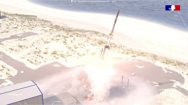
The test launch took place yesterday, 26 June 2023 at 22h CEST: see this French DoD bulletin, which also confirms that it was a test of the VMax glider on top of a sounding rocket.

A lot of chance sightings of the lingering missile exhaust cloud, illuminated by the sun, have been posted on Twitter, most of these from northern Spain but also a few from SW France. See for example here, here and here for a few examples. 

The French Ministère des Armées provided this image of  *a* launch. I have some doubts whether it is this particular VMAX launch, as the scenery seems sunlit with the sun in the South-Southeast (look at the shadows), while the launch was near 22 CEST, with the sun setting or just set in the Northwest...

[EDIT: the image seems to be a cgi render, i.e. not a real image, so that explains...]
 

Click to enlarge (image: Ministère des Armées, France)
[end of update]


More Atlantic tests: US or UK Trident test

This is not the only test in the Atlantic this June. Slightly earlier, a Navigational Warning, HYDROLANT 1302/23, appeared, strongly suggesting a Trident-II D5 SLBM test in the period 14 to 17 June 2023, launched from a submarine near Florida:

121246Z JUN 23
HYDROLANT 1302/23(GEN).
ATLANTIC OCEAN.
DNC 01, DNC 16.
1. HAZARDOUS OPERATIONS 141140Z TO 170029Z JUN
   IN AREAS BOUND BY:
   A. 28-39.00N 076-31.00W, 29-09.00N 076-13.00W,
      28-47.00N 074-59.00W, 28-17.00N 075-14.00W.
   B. 28-01.00N 073-25.00W, 28-07.00N 073-22.00W,
      27-53.00N 072-04.00W, 27-31.00N 071-57.00W,
      27-33.00N 072-24.00W.
   C. 25-46.00N 067-21.00W, 26-19.00N 067-01.00W,
      25-40.00N 065-42.00W, 25-08.00N 065-59.00W.
   D. 14-00.00N 042-36.00W, 14-14.00N 042-28.00W,
      13-41.00N 041-24.00W, 12-15.00N 039-09.00W,
      11-40.00N 039-30.00W, 12-41.00N 041-09.00W.
   E. 19-32.00S 007-27.00E, 18-42.00S 007-53.00E,
      19-52.00S 010-33.00E, 20-46.00S 010-02.00E,
      20-24.00S 009-17.00E, 20-12.00S 008-49.00E,
      20-06.00S 008-41.00E, 20-03.00S 008-33.00E,
      20-02.00S 008-29.00E.
2. CANCEL THIS MSG 170129Z JUN 23.


Here is the map I created from this Navigational Warning, with the areas A to E and the approximately 10600 km trajectory:

click map to enlarge

At the moment of writing, we are past the window of the Navigational Warning for this Trident test, but no word has come about a successful test launch yet.

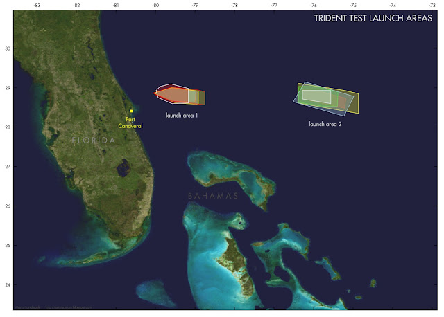
The launch area some 450 km out of the coast of Florida is one of two regularly used launch areas for Trident test launches. It is launch area 2 in the compilation below of data from nine 9 Trident test launches from the last 10 years I could identify:

click map to enlarge


The RV target area in front of the coast of Namibia is near one of three areas regularly used (target area 3 in the map below), but somewhat closer to the African coast than previous tests:

Click map to enlarge    


A few more maps for tis and histroic Trident tests: first, stage 1 and stage 2 splashdown areas for launches from launch area 1 (top) and launch area 2 (bottom):

Launch area 1 launches. Click map to enlarge

Launch area 2 launche. Click map to enlarge

As I indicated in an earlier analysis, I suspect that launch area 1, much closer to the Florida coast than launch area 2, is used for launches with a VIP audience.

The two maps below show the mid-Atlantic third stage splashdown zones for the two launch areas in question: