Saturday 16 September 2023

PAN is on the move again

click image to enlarge


In a recent post I mentioned that I recovered the enigmatic SIGINT satellite PAN/NEMESIS-1 (2009-047A) - we had lost sight of it for about a year - and that it appeared to be stationkeeping at 39.9 E, not far from Express AM-7, when I recovered it mid-August.

It was definitely in a stable position near Express AM-7 in August: but my most recent observations show that PAN has started to drift again, westward. This drift probably was initiated somewhere between September 7 and September 10, 2023, with a drift rate of about 0.16 degrees/day.

Above are four images, from August 22, August 27, September 10 and September 15, 2023 (they are 10 second exposures made by me from Leiden, the Netherlands with a ZWO ASI 6200MM Pro and Samyang 1.2/85 mm lens). If you look at the position of PAN relative to the neighbouring satellites, it is clear that it was stationary between August 22 and August 27, but started to drift after that.

PAN/NEMESIS-1 is a SIGINT satellite with an unusual history of frequent moves in position, and each time it moved it was being positioned very close to a commercial telecommunication satellite

From it's launch in 2009 until mid 2013, it was repositioned each few months (see my 2016 article in The Space Review). 

After mid 2013 it stopped moving and was steady at 47.7 E for many years: untill it started to move again in early 2021. 

Our coverage of it has been a bit spotty since that time (with an almost a year long coverage gap between 20 October 2022 and 22 August 2023, when I recovered it again). below is an updated diagram of it's relocations since it's launch in 2009:


click diagram to enlarge


The frequent moves between 2009 and 2013 had to do with the unique role of PAN/NEMESIS-1 in the drone war at that time: see this in-depth 2016 article about satellites and the drone war in The Intercept, and my 2016 article in The Space Review for the details.


PAN launch patch (collection author)

Friday 15 September 2023

The upcoming (?) reentry of Kwangmyŏngsŏng 3-2 (KMS 3-2), North Korea's last remaining satellite

KMS 3-2 (image: KCNA)


Somewhere this week, North Korea's last remaining - albeit probably not functional - satellite on orbit, Kwangmyŏngsŏng 3-2 (KMS 3-2, 2012-072A), will reenter (or has it already? See later...).

Kwangmyŏngsŏng 3-2 was launched on 12 December 2012 and was North Korea's first succesful satellite launch. Following in the footsteps of a later launch, KMS 4 from 2016 which reentered earlier this year on 30 June 2023, it is now set to have an uncontrolled reentry. 

With this, North Korea will lose the last satellite they have on orbit (the UNHA-3 upper stage of this launch is still on orbit).

It is not clear whether KMS 3-2, said to be a remote sensing satellite to monitor crops and weather, was ever functional. To my knowledge, no independent reception of signals from the payload has ever been reported.

Unfortunately, orbital updates for KMS 3-2 stopped to appear in the CSpOC catalogue after September 12. The last available orbit has epoch 12 Sept 2023 15:20:30 UTC. My reentry forecast based on that orbit was 16 Sept 2023 18:00 UTC ± 20 hrs.


click diagram to enlarge


A TIP was not issued (it wasn't for KMS-4 either at the time), but a reentry notice was suddenly added to the KMS 3-2 entry in the CSpOC SATCAT on Sept 15, stating 13 September 2023 as the reentry date.

I think that date is not correct, and merely an 'administrative decay'  - meaning they either don't really know, or are not willing to share, when it really reentered. 

The last known orbit from September 12 is a 226 x 235 km orbit and even using extremely high values for solar activity (higher than they in reality were) I can't get it to reenter earlier than Sept 15-16 in my GMAT model, nor in SatEvo. I simply don't see it coming down from that altitude within a day, unless something drastic happened (e.g. a structural disintegration of the satellite before the actual reentry). For reference, it took KMS 4 some four-and-a-half days to come down from that altitude and reenter in June.


click diagram to enlarge


So it looks like either CSpOC lost the object and doesn't really know, or they do not want to to share the last whereabouts of KMS 3-2 (e.g. from a notion that this would help the North Koreans in some way).

Meanwhile, after two failed launch attempts the past months using a new carrier rocket, North Korea said it will attempt to loft a new satellite into orbit in October.

I recently talked to the website North Korea News about the upcoming KMS 3-2 reentry, which you can read here.

Firefly Alpha 'Victus Nox' Rapid Response launch [UPDATED]


click to enlarge

On September 15 at 2:28 UTC, Firefly Aerospace succesfully launched a Firefly Alpha rocket from SLC-2 at Vandenberg Space Force Base in California. It carried 'Victus Nox', a small satellite, as a Rapid Response launch exercise. 

The latter is a program where a payload is launched with a very short notice (60 hours) during which the carrier rocket and payload have to be readied and launched.

Navigational Warnings for the launch appeared on September 14. They point to launch into a ~97.8 degree inclined Sun-synchronous orbit (see map above).

140310Z SEP 23
NAVAREA XII 631/23(17,18,19).
EASTERN NORTH PACIFIC.
1. HAZARDOUS OPERATIONS:
   A. 150157Z TO 150319Z SEP, ALTERNATE
      160157Z TO 160319Z SEP IN AREA BOUND BY
      25-50.00N 126-00.00W, 26-00.00N 126-35.00W,
      25-28.00N 126-51.00W, 24-59.00N 125-50.00W,
      25-31.00N 125-33.00W.
   B. 150406Z TO 150413Z SEP, ALTERNATE
      160406Z TO 160413Z SEP IN AREA BOUND BY
      46-21.00N 143-08.00W, 28-18.00N 147-24.00W,
      27-54.00N 146-22.00W, 46-06.00N 141-21.00W.
2. CANCEL THIS MSG 160513Z SEP 23.//

Firefly Aerospace announced on September 15 that the launch was successful. Some imagery of te launch is here.


UPDATE:

An object has now been catalogued by CSpOC as nr 57861 (2023-142A) in a 97.32 deg inclined, 476 x 531 km sun-synchronous orbit:


click image to enlarge

It has a slightly lower orbital altitude than I estimated and 0.5 degree lower orbital inclination:


click image to enlarge

Sunday 10 September 2023

Recovering USA 310, PAN and Trumpet 2


click image to enlarge

Our coverage of classified objects in high altitude orbits has been waning over the past few years. In February, I made a first attempt to recover some. In the past two weeks, I again recovered a number of these objects, as a by product of testing a ZWO ASI6200MM camera (that ultimately is going to be installed on the roof of the Delft Technical University Aerospace faculty).

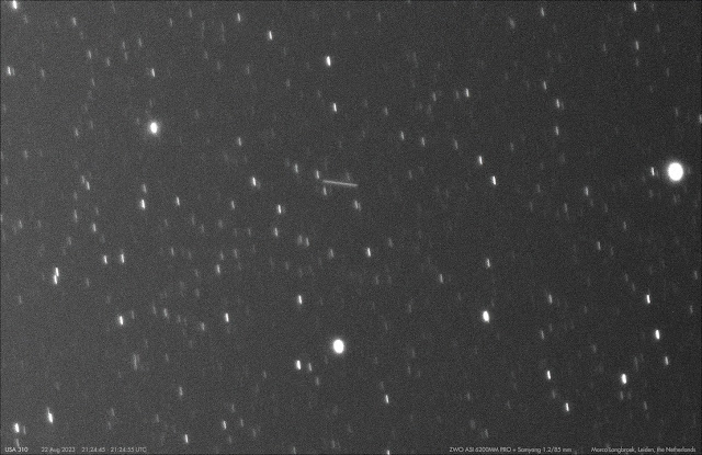
One of the objects I recovered, is a very unusual one: USA 310 (2020-083A). This object is in an odd 58.5 degree inclined, 11097 x 11074 km MEO orbit. It was launched on 13 November 2020 as NROL-101 (see this 2020 blogpost). We tracked it and it's Centaur upper stage for a couple of weeks, but lost it after February 2021. In other words: it had not been seen for the last 2.5 years!

That is, untill I serendipitously picked it up last August 22, while imaging geostationary satellites. In the imagery, a streak was encountered (see image above). It is a fit with USA 310. I managed to track it again during several nights the past two weeks. Frankly, I am not 100% sure whether it is USA 310 or the Centaur upper stage from that launch, but it does not seem to have the periodic brightness variation the Centaur upper stage showed in 2020/2021. And it is (relatively) bright only in the eastern part of the sky, just like USA 310 back in 2020/2021.

More objects were recovered. Several geosynchronous objects that hadn't been observed for a while, were imaged. One of them, the enigmatic PAN (2009-047A), had moved (just as it used to frequently do in the past, see my in-depth article on PAN in The Space Review from October 2016). I recovered it at longitude 39.7 degrees East, in the vicinity of Express AM-7. Observations over the past two week show it is stationkeeping, so it appears to be still operational (see also this post from 2021, when after several years of being stable at 47.7 E, it started to drift). Below is the recovery image:


click image to enlarge


Coverage of high altitude objects in HEO has likewise become spotty. I observed a number of them late February (see this blogpost), and again did so the past two weeks (a.o. TRUMPET 1 and USA 278). I recovered the SIGINT satellite TRUMPET-2 (1995-034A) on September 5, which had not been seen for almost 2 years:


One reason why I only sporadically track objects in GEO and HEO is that identifying and measuring them is much more labour-intensive than video-tracking objects in Low Earth Orbit, as identifying and measuring is still done manually for these objects by me. One day, I should get myself some software to make this a more easy task...

Wednesday 6 September 2023

A new test attempt of the LRHW hypersonic missile from Cape Canaveral

click map to enlarge


A few days ago, Navigational Warnings (NAVAREA IV 1030/23) were published that point to a new test launch attempt of the Long Range Hypersonic Weapon (LRHW) from Cape Canaveral in the period 6 - 8 September 2023.

The Navigational Warning delineates seven hazard zones which, just like for the scrubbed test in March, delineate a signature "forked" trajectory (see map above):

041402Z SEP 23
NAVAREA IV 1030/23(GEN).
NORTH ATLANTIC.
FLORIDA.
1. HAZARDOUS OPERATIONS 061400Z TO 081841Z SEP
   IN AREAS BOUND BY:
   A. 28-30.57N 080-33.08W, 28-30.00N 080-27.00W,
      28-27.00N 080-02.00W, 28-20.00N 080-02.00W,
      28-22.00N 080-21.00W, 28-25.18N 080-34.79W.
   B. 28-04.00N 078-49.00W, 28-11.00N 078-47.00W,
      27-43.00N 076-32.00W, 27-31.00N 076-31.00W.
   C. 28-27.00N 080-02.00W, 28-22.00N 079-09.00W,
      28-11.00N 078-47.00W, 28-04.00N 078-49.00W,
      28-03.00N 079-12.00W, 28-20.00N 080-02.00W.
   D. 23-00.00N 060-00.00W, 20-30.00N 060-00.00W,
      22-00.00N 063-00.00W, 24-00.00N 063-00.00W.
   E. 28-30.00N 060-00.00W, 26-00.00N 060-00.00W,
      25-00.00N 063-00.00W, 27-00.00N 063-00.00W.
   F. 28-00.00N 056-00.00W, 30-00.00N 042-30.00W,
      32-00.00N 042-30.00W, 30-00.00N 056-00.00W.
   G. 19-00.00N 057-00.00W, 11-30.00N 041-00.00W,
      13-30.00N 041-00.00W, 21-00.00N 057-00.00W.
2. CANCEL THIS MSG 081941Z SEP 23.

Launch is likely from a TEL on Cape Canaveral pad 46.

The hazard areas are very similar to, but not exactly the same  as, those for the scrubbed March test (areas fro that scrubbed test marked in red in the comparison map below):


click map to enlarge

Meanwhile, at the other side of the United States, a routine test launch of an unarmed  Minuteman-III ICBM from Vandenberg in California to the Reagan Test Range on Kwajalein in the Marshall Islands is also planned for 6-7 September 2023 UTC, according to both a Vandenberg Space Force Base news bulletin and Navigational Warnings published:

click image to enlarge


The hazard zones in the map above come from these two Navigational Warnings:

292100Z AUG 23
NAVAREA XII 597/23.
1. HAZARDOUS OPERATIONS 06 THRU 07 SEP DAILY:    
   A. 0631Z TO 1337Z IN AREA BOUND BY
      34-38.00 N 121-23.00 W, 34-38.00 N 120-52.00 W,
      34-44.00 N 120-35.00 W, 34-55.00 N 120-35.00 W,
      34-56.00 N 120-57.00 W, 34-56.00 N 121-22.00 W.
   B. 0631Z TO 1326Z IN AREA BOUND BY
      34-20.00 N 124-33.00 W, 34-35.00 N 124-35.00 W,
      34-52.00 N 122-01.00 W, 34-37.00 N 121-59.00 W.
   C. 0631Z TO 1326Z IN AREA BOUND BY
      32-36.00 N 136-04.00 W, 32-49.00 N 136-08.00 W,
      33-01.00 N 135-05.00 W, 32-48.00 N 135-02.00 W.
   D. 0631Z TO 1431Z IN AREA BOUND BY
      13-17.00 N 173-49.00 E, 13-36.00 N 174-20.00 E,
      13-16.00 N 174-33.00 E, 12-57.00 N 174-01.00 E.
2. CANCEL THIS MSG 081531Z SEP 23.


282325Z AUG 23
HYDROPAC 2811/23(81).
NORTH PACIFIC.
MARSHALL ISLANDS.
DNC 12.
1. HAZARDOUS OPERATIONS 060700Z TO 061411Z SEP,
    ALTERNATE 070700Z TO 071411Z SEP
    IN AREAS:
   A. 09-16.00N 167-22.00E, 09-23.00N 167-33.00E,
      09-34.00N 167-26.00E, 09-43.00N 167-33.00E,
      10-09.00N 168-13.00E, 09-31.00N 168-38.00E,
      09-05.00N 167-58.00E, 09-02.00N 167-47.00E,
      08-58.00N 167-33.00E.
   B. 11-51.00N 171-59.00E, 12-37.00N 171-21.00E,
      12-24.00N 170-59.00E, 11-39.00N 171-22.00E,
      10-53.00N 171-58.00E, 11-05.00N 172-20.00E.
2. CANCEL THIS MSG 071511Z SEP 23.


UPDATE: 

The Minuteman-III test from Vandenberg to Kwajalein has happened, at 6 sept 2023 8:26 UTC, per a Vandenberg SFB news bulletin. According to the Air Force Global Strike Command, the test involved three reentry vehicles.

UPDATE II:

The test of the LRHW out of Cape Canaveral was aborted, just like earlier in March