Wednesday 9 February 2022

This week: rainshowers with a slight chance of falling satellites

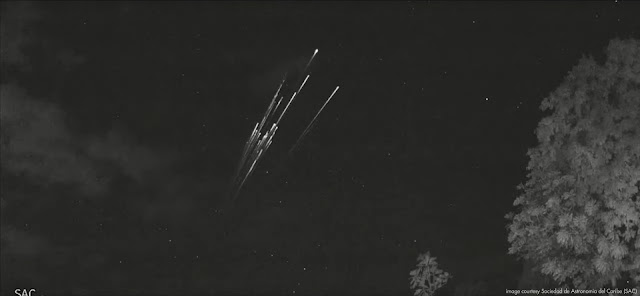
The spectacular image above is a frame from video footage obtained by cameras at AƱasco, Puerto Rico, part of a cameranetwork from the Sociedad de Astronomia del Caribe (SAC). It was shot on 7 February 2022 near 6:40 UT (2:40 local time) and shows what clearly is a satellite reentry, the reentering satellite spectacularly breaking up into many fragments.

Below is the actual video. It shows two objects appearing about 1 minute apart, both reentering and fragmenting. Especially the second object is spectacular. The two objects could belong to one object that has broken up earlier; or be two separate objects close together in the same orbital plane.


The reentering object(s) can be identified as belonging to a batch of 45 49 Starlink satellites launched on 3 February 2022, two-and a half days before the reentry sighting from Puerto Rico.

A day after the launch, when most of the deployed satellites yet had to raise their orbits, a Coronal Mass Ejection (CME) from the Sun arrived at earth, creating a geomagnetic storm

During a geomagnetic storm, the upper atmosphere warms up and expands somewhat, causing an increase in drag in low orbital altitudes. SpaceX therefore put their just launched satellites, still in a very low orbit, into safe mode and a least-drag attitude. 

This however prevented them from raising their orbits, and it did so long enough to make it impossible for some 40 of them to be rescued. Over the past days a number of them (at least three, possibly more, including the object over Puerto Rico, at time of writing (9 February 16:00 UT)) have already reentered and the other objects, some 40 in total according to SpaceX, will reenter over the coming week.

Fourty (40!) satellites reentering in only a week or so, is unique. The coming week, the chances of seeing a satellite reentry are therefore larger than usual for anyone between 53 N and 53 S. So keep an eye on the sky!

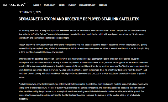
screenshot of Feb 8 announcement on the SpaceX website

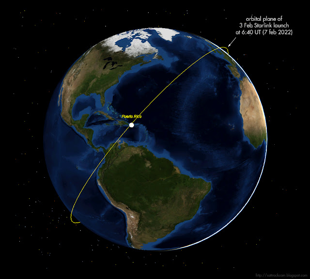
Though it remains to be seen which of the 40 satellites it actually was, the Feb 7, 6:40 UT, Puerto Rico sighting can be possitively linked to this deluge of decaying Starlink satellites. 

One clue is that the orbital plane of this launch was over Puerto Rico near the time of the event, and the direction of movement (SW-NE) matches it.


To get even more certainty, I did some astrometry on the footage and fitted a rough circular orbit to the measured positions.The rough orbital fit I get - I measured three fragments-  yield orbital inclinations in the range of 54-56 degrees: Starlink satellites are in 53.2 degree inclined orbits, so this is close enough (given the error margin) to conclude that the reentering object fits with the Starlink orbital plane. The RAAN values also match to a degree or so. So there is very little doubt that this was a Starlink satellite reentering.

One reason why I checked this, is that someone suggested another candidate, a Falcon 9 rocket stage from a 2017 launch (2017-014B), which was also expected to reenter around this date (in fact it had already reentered a day earlier) and had its orbital plane passing over Puerto Rico at the time of the event. This rocket stage however had an orbital inclination of 22 degrees, which is clearly much lower than what I get for the reentering object in the footage.

Starlink satellites are not very big and do not have big rocket engines, so there is very little chance that anything remains and reaches Earth surface from these reentries: it will all burn up in the atmosphere. 

Note: I thank Eddie Irizarry for alerting me to the Puerto Rico event


UPDATE 17:30 UT (9 Feb 2022):
For some 21 of the 45 49 Starlink satellites in question, orbital elements have now been released by CSpOC. A quick assessment with SatEvo suggests reentries happening over the coming week, up to mid-February.

Wednesday 2 February 2022

The upcoming classified NROL-87 launch

click map to enlarge


If weather cooperates, SpaceX will launch a classified payload for the National Reconnaissance Office (NRO) on 2 February 2022 at 20:18 UT [the launch eventually was at 21:27 UT]. This launch, from Vandenberg SLC-4 in California, is designated NROL-87.

Both (limited) specifications in a published contract for this launch (which states the intended orbital inclination and semi-major axis as respectively 97.4 degrees and 6890.7 km), as well as the position and orientation of hazard zones published in Navigational Warning NAVAREA XII 45/22 point to a launch into a 97.4 degree inclined, Sun-Synchronous Low Earth Orbit at about 512 km orbital altitude.

Analysts suspect the classified payload is one of a new generation of electro-optical IMINT satellites (either the first, or possibly the second, after USA 290/NROL-71, but in the latter case in a clearly different orbit) that is a follow-up to the KH-11 program. The sun-synchronous character of the intended orbit supports interpretation as an IMINT mission.

The image in top of this post gives the launch trajectory. The hazard areas I plotted in the map are from Navigational Warning NAVAREA XII 45/22 and they match a launch into an orbital plane with the quoted orbital inclination of 97.4 degrees:

280731Z JAN 22
NAVAREA XII 45/22(17,18,19).
EASTERN NORTH PACIFIC.
CALIFORNIA.
1. HAZARDOUS OPERATIONS:
   A. 1907Z TO 2138Z DAILY 02 AND 03 FEB
      IN AREA BOUND BY
      34-42N 120-41W, 34-41N 120-32W,
      34-31N 120-26W, 34-18N 120-30W,
      33-40N 120-53W, 32-10N 121-24W,
      31-25N 121-27W, 31-07N 121-40W,
      31-09N 121-55W, 31-35N 121-52W,
      32-17N 121-27W, 34-29N 120-46W.
   B. 2110Z TO 2249Z DAILY 02 AND 03 FEB
      IN AREAS BOUND BY
      54-00N 144-30W, 50-45N 134-30W,
      29-15N 140-00W, 32-30N 150-30W.
2. CANCEL THIS MSG 032349Z FEB 22.


The Falcon 9 upper stage from the launch makes a controlled reentry at the end of the first revolution, in the Northeast Pacific roughly between Alaska and Hawaii (the red box marked "B" in the map above). 

If launch is indeed near 20:18 UT (the launch window of the Navigational Warning runs from 19:07 to 21:38 UT), then the orbital plane launched into results in passes near noon and midnight local time and (if the semi-major axis is correct) a ~5-6 day repeating ground track. A pre-launch estimated elset is here.

The Launch Patch for NROL-87 shows an Ibex keeping a watchfull eye over its territory:


image: NRO

The North Korean Hwasong-12 test of 29 January 2022

click to enlarge
 

On 29 January 2022 at 22:52 UT (30 January 2022, 7:52 local time in North Korea), North Korea test-fired a Hwasong-12 IRBM. The missile impact point was in the Sea of Japan. According to western sources, it had as flight time of ~30 minutes with a range of ~800 km and an apogee of ~2000 km (the yellow trajectory in the reconstruction above). In other words, a highly lofted trajectory, such as we have seen earlier during various 2017 North Korean missile tests. 

Such a lofted trajectory can be chosen for two reasons: to avoid overflying other countries (Japan) and/or to be able to monitor most of the flight from North Korea itself.

Going from the reporteded apogee altitude and range (~2000 km and ~800 km), I find that this same missile would have an implicated maximum range of ~4300 km (white line in reconstruction above, and red circle) when launched on a more normal, more depressed ballistic trajectory. 

This fits with results for earlier Hwasong-12 lofted test flights, such as the 13 May 2017 test, and is slightly more than the more depressed Hwasong-12 test firings over Japan of 29 August 2017 (which as I have pointed out partly failed but was intended to fly ~3300 km) and 14 september 2017 (which flew ~3700 km).


images: KCNA/Rodong Sinmun


Images of the launch published by the North Korean Government in Rodong Sinmun (above) include two images of the earth reportedly made from the missile, showing the Korean peninsula.

From the two published launch pictures, the launch location of the missile was geolocated by Joseph Dempsey to a spot near Mupyong-ri at 40.6112 N, 126.4257 E. In the image below I match particular terrain details in the drone launch image released by North Korea to a Google Earth image of that particular spot. Which is a familiar spot by the way: it is the same courtyard where on 28 July 2017 the first successful launch of a Hwasong-14 ICBM was carried out (at that time the courtyard was still grass covered: in the meantime it has been paved). On recent Google Earth imagery, what I think could very well be a monument built to commemorate the 2017 launch is visible near the southern courtyard perimeter (we know the North Korean's built commemorative monuments on other test launch sites). I have indicated it in the image below.


click to enlarge

The text of the post-launch North-Korean Government announcement in Rodong Sinmun of 31 January 2022 is interesting. It claims that the  "test-fire was aimed to selectively evaluate the missile being produced and deployed and to verify the overall accuracy of the weapon system". 

As Ankit Panda has pointed out, this probably indicates that this was not a test of a new improved Hwasong-12 variant: but rather a test launch to demonstrate the readiness of a deployed system of production grade missiles (similar to frequent test launches of Minuteman ICBM's and Trident-II SLBM's by the USA). We might therefore see more of such periodical launches in the future.

This was the 7th launch of a Hwasong-12, and the first launch of this type since 15 September 2017.