Showing posts with label France. Show all posts

Saturday, 6 April 2024

A possible French Missile test over the Gulf of Biscaye on April 10-11 [UPDATED]

click map to enlarge

An odd Navigational Warning has appeared, for "space debris" along a 420-km trackline over the Gulf of Biscaye, from a point some 37 km southwest of Concarneau on the southern coast of Bretagne to a point some 20 km west of the French missile test base DGA Essais de Missiles near Biscarosse, southwest France. The Navigational Warning is for April 10 and 11, 2024, from 10:00 to 14:30 UTC (12:00 to 16:30 CEST).

I do not think this Navigational Warning is really about "space debris", but rather believe some sort of missile test is concerned

The southern end of the 420 km trackline being close to the French missile testing base at Biscarosse, while the northern end is in the area that the French Navy uses to test-launch SLBM's, is a giveaway that it rather concerns some kind of missile. Also, a controlled reentry of "space debris" so close to the French coast would be very odd. So I do not believe for a second that the Warning truely is for "space debris"

This is the text of the Navigational Warning:

051439Z APR 24
HYDROLANT 716/24(37).
BAY OF BISCAY.
FRANCE.
DNC 08.
1. HAZARDOUS OPERATIONS, SPACE DEBRIS
   101000Z TO 101430Z, ALTERNATE 111000Z TO 111430Z
   ALONG TRACKLINE JOINING
   47-36.00N 004-13.00W, 44-20.00N 001-30.00W.
2. CANCEL THIS MSG 111530Z APR 24.


Because the trackline starts in the area that the French use for SLBM test launches, and because "space debris" would perhaps indicate something with a high apogee, my initial thought (see also the title of the map above) was that it might concern a test of a new SLBM stage (it is definitely not a full M51 SLBM test, the range is much too short for that and those tests fire westwards).

However, the 420 km length of the indicated track line, would also match two medium-range to long-range cruise-missiles of the French armed forces: the ASMP-A, which is airlaunched and meant to deliver a nuclear warhead; and the French-British SCALP-EG, also known as Storm Shadow, which is also air-launched and has a conventional warhead.

If it concerns a ship- or submarine-launched cruise-missile instead, then the MdCN would also be an option, but that missile would have a 2-3 times as large range (edit: but see below).

Calling a cruise-missile "space debris" is a stretch however. So many open questions remain as to the character of the missile in question.


UPDATE 19 Apr 2024:

The test happened on April 18 (the Navigational Warning was re-issued twice, for April 17 and 18). The French Ministry of Defense announced that it concerned a double launch of the Missile de Croisière Naval (MdCN) Naval cruise missile, one launched from the Frigate Aquitaine, the other from a nuclear  submarine in the Suffren class. The target was on land at DGA Essais de Missiles near Biscarosse.

Thursday, 2 November 2023

An upcoming French SLBM test in the Atlantic, ARRW, and a failed Minuteman test in the Pacific

click map to enlarge


click image to enlarge

While strong Autumn storms and rainshowers (the image above is an APT image my radio received from NOAA 19 this morning, showing storm Ciarán over the Channel) are making satellite observations impossible, various missile test activities the past and upcoming weeks keep me occupied.

In a previous post I wrote about a Missile Defense test, FTM-48 north of Hawaii on October 25, and indications for another LRHW test from Cape Canaveral (it is unknown whether the latter test happened: FTM-48 reportedly was a success).

In this post, I will write about three other missile tests


French M51 SLBM test

First, an upcoming French M51 SLBM test to be launched from DGA Essais de missiles near Biscarrosse on the southwest coast of France. Its trajectory is over the Gulf of Biscaye and northern Atlantic towards a target area some 830 km south of Saint-Pierre et Miquelon (two French islands in front of the Newfoundland coast). 

Two Navigational Warnings (HYDROLANT 2484/23 and NAVAREA IV 1273/23 ) have appeared that indicate the test, with a window running from November 6 to December 1. Below is a map with the hazard zones for this test and the text of the Navigational Warnings:

click map to enlarge

311957Z OCT 23
HYDROLANT 2484/23(36,37,38).
BAY OF BISCAY.
NORTH ATLANTIC.
FRANCE.
DNC 08.
1. MISSILE OPERATIONS 0200Z TO 1200Z
   DAILY 06 NOV THRU 01 DEC
   IN AREAS BOUND BY:
   A. 44-26.33N 001-15.67W, 44-28.00N 001-20.00W,
      44-35.00N 001-27.75W, 44-44.75N 002-17.25W,
      44-23.50N 002-25.00W, 44-14.75N 001-35.75W,
      44-17.25N 001-26.75W, 44-18.00N 001-17.00W.
   B. 45-14.20N 005-17.58W, 45-22.57N 006-11.45W,
      45-05.33N 006-16.65W, 44-57.02N 005-23.05W.
   C. 45-14.20N 005-17.58W, 44-57.02N 005-23.05W,
      44-23.50N 002-24.98W, 44-44.75N 002-17.25W.
   D. 47-08.05N 014-18.15W, 47-20.18N 017-10.22W,
      45-33.87N 017-23.13W, 45-22.12N 014-36.47W.
   E. 47-05.02N 029-54.25W, 46-58.67N 031-53.87W,
      46-11.73N 031-47.78W, 46-17.98N 029-49.87W.
2. CANCEL THIS MSG 011300Z DEC 23.


020945Z NOV 23
NAVAREA IV 1273/23(14).
WESTERN NORTH ATLANTIC.
1. HAZARDOUS OPERATIONS 0200Z TO 1200Z DAILY
   06 NOV THRU 01 DEC IN AREA WITHIN
   80 MILES OF 39-21.36N 057-43.60W.
2. CANCEL THIS MSG 011300Z DEC 23.//

The indicated range for this test is about 5100 km, which is somewhat less than the test on 28 April 2021, as can be seen in this map comparing the two tests:

click map to enlarge

The test involves a manoeuvre changing the heading of the missile somewhere after jettison of the third stage. The shorter range, and closer range to the splashdown zones of the stages, could indicate either a more loftet test or (more likely) a heavier payload.

UPDATE:

The Navigational Warnings have been re-issued for Nov 16 - Dec 1 and adding an additional time window (18:00-23:59 UTC):

161904Z NOV 23
HYDROLANT 2631/23(36,37,38).
BAY OF BISCAY.
NORTH ATLANTIC.
FRANCE.
DNC 08.
1. MISSILE OPERATIONS 0001Z TO 1200Z AND
   1800Z TO 2359Z DAILY 16 NOV THRU 01 DEC
   IN AREAS BOUND BY:
A. 44-18.00N 001-17.00W, 44-17.25N 001-26.75W,
   44-14.75N 001-35.75W, 44-23.50N 002-25.00W,
   44-44.75N 002-17.25W, 44-35.00N 001-27.75W,
   44-28.00N 001-20.00W, 44-26.33N 001-15.67W.
B. 45-22.57N 006-11.45W, 45-05.33N 006-16.65W,
   44-57.02N 005-23.05W, 45-14.20N 005-17.58W.
C. 44-57.02N 005-23.05W, 45-14.20N 005-17.58W,
   44-44.75N 002-17.25W, 44-23.50N 002-24.98W.
D. 47-20.18N 017-10.22W, 45-33.87N 017-23.13W,
   45-22.12N 014-36.47W, 47-08.05N 014-18.15W.
E. 46-58.67N 031-53.87W, 46-11.73N 031-47.78W,
   46-17.98N 029-49.87W, 47-05.02N 029-54.25W.
2. CANCEL HYDROLANT 2628/23.
3. CANCEL THIS MSG 020100Z DEC 23.

UPDATE 18 Nov 2023:

The SLBM test happened this evening, 18 Nov 2023, around 18:20 UTC. Several spectacular images and video footage of illuminated exhaust cloluds were obtained from France, Spain and Italy.


US AGM-183 ARRW hypersonic test

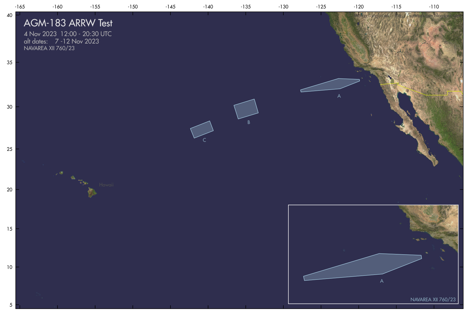
On the other side of the World, in the Northwest Pacific between California and Hawaii, another AGM-183 ARRW hypersonic missile test appears to be on the calendar for November 4th, with an alternative window between Nov 7 and 13, as indicated by this Navigational Warning:

300930Z OCT 23
NAVAREA XII 760/23(18,19).
EASTERN NORTH PACIFIC.
CALIFORNIA.
1. HAZARDOUS OPERATIONS 041200Z TO 042030Z NOV,
   ALTERNATE 1300Z TO 2130Z DAILY 07 AND 13 NOV
   IN AREAS BOUND BY:
   A. 31-55.63N 127-43.18W, 33-12.37N 122-41.36W,
      33-06.52N 119-53.89W, 32-55.31N 119-51.90W,
      32-03.13N 122-28.33W, 31-40.94N 127-39.48W.
   B. 28-34.12N 135-59.93W, 30-09.63N 136-34.60W,
      30-52.95N 133-51.97W, 29-16.77N 133-19.65W.
   C. 26-17.92N 141-50.77W, 27-26.72N 142-21.67W,
      28-20.65N 139-47.33W, 27-11.27N 139-17.77W.
2. CANCEL THIS MSG 132230Z NOV 23.//

click map to enlarge

 The areas are similar to earlier known or suspected ARRW tests:

click map to enlarge

This missile must be one of the last of the (scrapped) AGM-183 program left.


Failed Minuteman-III ICBM test

Meanwhile, November 1 saw what should have been a rather routine Minuteman-III ICBM test from Vandenberg to Illegini Island, Kwajalein, going awry.

According to the Air Force Global Strike Command, an anomaly occurred and the missile was terminated in flight. A nice photograph of the launch is here.

Below is the map with the trajectory the missile should have flown, and the relevant Navigational Warnings:

click map to enlarge

260936Z OCT 23
NAVAREA XII 749/23(18,19,81).
EASTERN NORTH PACIFIC.
CALIFORNIA.
1. HAZARDOUS OPERATIONS 01 AND 02 NOV:
   A. 0631Z TO 1335Z IN AREA BOUND BY
      34-40.00N 121-25.00W, 34-40.00N 120-54.00W,
      34-46.00N 120-37.00W, 34-57.00N 120-37.00W,
      34-58.00N 120-58.00W, 34-58.00N 121-24.00W.
   B. 0631Z TO 1340Z IN AREA BOUND BY
      34-19.00N 124-36.00W, 34-40.00N 124-39.00W,
      34-56.00N 121-59.00W, 34-36.00N 121-56.00W.
   C. 0631Z TO 1347Z IN AREA BOUND BY
      32-30.00N 137-13.00W, 32-48.00N 137-18.00W,
      33-04.00N 136-01.00W, 32-45.00N 135-56.00W.
   D. 0631Z TO 1431Z IN AREA BOUND BY
      14-36.00N 175-34.00E, 14-54.00N 175-13.00E,
      14-35.00N 174-55.00E, 14-23.00N 174-49.00E,
      14-17.00N 174-54.00E, 14-17.00N 175-15.00E.
2. CANCEL THIS MSG 021531Z NOV 23.//


270329Z OCT 23
HYDROPAC 3397/23(81).
NORTH PACIFIC.
MARSHALL ISLANDS.
DNC 12.
1. HAZARDOUS OPERATIONS 010700Z TO 011411Z NOV,
   ALTERNATE 020700Z TO 021411Z NOV
   IN AREAS BOUND BY
   A. 09-53.00N 168-50.00E, 09-55.00N 168-47.00E,
      09-32.00N 168-09.00E, 09-24.00N 167-35.00E,
      09-09.00N 167-08.00E, 08-45.00N 167-23.00E,
      09-01.00N 167-49.00E, 08-51.00N 168-22.00E,
      08-54.00N 168-32.00E, 09-18.00N 169-10.00E,
      09-20.00N 169-11.00E.
   B. 11-08.00N 172-02.00E, 12-18.00N 171-37.00E
      13-20.00N 170-42.00E, 13-28.00N 170-33.00E
      13-20.00N 170-07.00E, 13-14.00N 170-00.00E,
      13-07.00N 169-54.00E, 12-01.00N 170-24.00E,
      11-54.00N 170-31.00E, 10-59.00N 171-14.00E,
      10-52.00N 171-22.00E, 10-57.00N 171-47.00E,
      10-59.00N 171-54.00E.
2. CANCEL THIS MSG 021511Z NOV 23.//

Thursday, 22 June 2023

UPDATED: Ceci n'est pas une pipe... (French and US missile tests in the Atlantic in June)

click map to enlarge

They must love Magritte over at the French DoD, looking at the shape of the exclusion zones for a missile test published as Navigational Warnings HYDROLANT 1371/23 and HYDROLANT 1372/23.

The Navigational Warnings point to a French missile test launched from DGA Essais de Missiles near Biscarosse in Nouvelle-Aquitaine, over the Bay of Biscaye, in the period 26 to 30 June 2023. Below is the text of the Navigational Warnings:

201628Z JUN 23
HYDROLANT 1371/23(36,37).
BAY OF BISCAY.
CELTIC SEA.
EASTERN NORTH ATLANTIC.
FRANCE.
DNC 08, DNC 19.
1. MISSILE OPERATIONS 1230Z TO 2230Z DAILY
   26 THRU 30 JUN IN AREA BOUND BY
   46-33.50N 004-51.90W, 48-27.00N 010-03.00W,
   48-27.00N 015-12.00W, 47-04.50N 014-59.10W,
   46-05.70N 013-39.00W, 44-02.30N 001-20.00W,
   44-49.50N 001-12.30W.
2. CANCEL THIS MSG 302330Z JUN 23.


201646Z JUN 23
HYDROLANT 1372/23(36).
CELTIC SEA.
EASTERN NORTH ATLANTIC.
DNC 19.
1. MISSILE OPERATIONS 1230Z TO 2230Z DAILY
   26 THRU 30 JUN IN AREA BOUND BY
   50-15.00N 011-08.00W, 49-40.00N 010-11.00W,
   48-27.00N 010-03.00W, 48-27.00N 015-12.00W,
   49-51.00N 013-15.00W.
2. CANCEL THIS MSG 302330Z JUN 23.


The shape and range of the Navigational Warnings suggest something SRBM/MRBM rather than, for example an SLBM. The curved shape is odd. After I posted the Warnings on Twitter, there has been some speculation that this might be a test of a hypersonic glider, perhaps V-Max. Taking into account the curve in the exclusion area, the range of this test would be in the order of 1250 km.


UPDATE 27 June 2023:

The test launch took place yesterday, 26 June 2023 at 22h CEST: see this French DoD bulletin, which also confirms that it was a test of the VMax glider on top of a sounding rocket.

A lot of chance sightings of the lingering missile exhaust cloud, illuminated by the sun, have been posted on Twitter, most of these from northern Spain but also a few from SW France. See for example here, here and here for a few examples. 

The French Ministère des Armées provided this image of  *a* launch. I have some doubts whether it is this particular VMAX launch, as the scenery seems sunlit with the sun in the South-Southeast (look at the shadows), while the launch was near 22 CEST, with the sun setting or just set in the Northwest...

[EDIT: the image seems to be a cgi render, i.e. not a real image, so that explains...]
 

Click to enlarge (image: Ministère des Armées, France)
[end of update]


More Atlantic tests: US or UK Trident test

This is not the only test in the Atlantic this June. Slightly earlier, a Navigational Warning, HYDROLANT 1302/23, appeared, strongly suggesting a Trident-II D5 SLBM test in the period 14 to 17 June 2023, launched from a submarine near Florida:

121246Z JUN 23
HYDROLANT 1302/23(GEN).
ATLANTIC OCEAN.
DNC 01, DNC 16.
1. HAZARDOUS OPERATIONS 141140Z TO 170029Z JUN
   IN AREAS BOUND BY:
   A. 28-39.00N 076-31.00W, 29-09.00N 076-13.00W,
      28-47.00N 074-59.00W, 28-17.00N 075-14.00W.
   B. 28-01.00N 073-25.00W, 28-07.00N 073-22.00W,
      27-53.00N 072-04.00W, 27-31.00N 071-57.00W,
      27-33.00N 072-24.00W.
   C. 25-46.00N 067-21.00W, 26-19.00N 067-01.00W,
      25-40.00N 065-42.00W, 25-08.00N 065-59.00W.
   D. 14-00.00N 042-36.00W, 14-14.00N 042-28.00W,
      13-41.00N 041-24.00W, 12-15.00N 039-09.00W,
      11-40.00N 039-30.00W, 12-41.00N 041-09.00W.
   E. 19-32.00S 007-27.00E, 18-42.00S 007-53.00E,
      19-52.00S 010-33.00E, 20-46.00S 010-02.00E,
      20-24.00S 009-17.00E, 20-12.00S 008-49.00E,
      20-06.00S 008-41.00E, 20-03.00S 008-33.00E,
      20-02.00S 008-29.00E.
2. CANCEL THIS MSG 170129Z JUN 23.


Here is the map I created from this Navigational Warning, with the areas A to E and the approximately 10600 km trajectory:

click map to enlarge

At the moment of writing, we are past the window of the Navigational Warning for this Trident test, but no word has come about a successful test launch yet.

The launch area some 450 km out of the coast of Florida is one of two regularly used launch areas for Trident test launches. It is launch area 2 in the compilation below of data from nine 9 Trident test launches from the last 10 years I could identify:

click map to enlarge


The RV target area in front of the coast of Namibia is near one of three areas regularly used (target area 3 in the map below), but somewhat closer to the African coast than previous tests:

Click map to enlarge    


A few more maps for tis and histroic Trident tests: first, stage 1 and stage 2 splashdown areas for launches from launch area 1 (top) and launch area 2 (bottom):

Launch area 1 launches. Click map to enlarge

Launch area 2 launche. Click map to enlarge

As I indicated in an earlier analysis, I suspect that launch area 1, much closer to the Florida coast than launch area 2, is used for launches with a VIP audience.

The two maps below show the mid-Atlantic third stage splashdown zones for the two launch areas in question:


Sunday, 9 April 2023

An upcoming French SLBM test in the Atlantic [UPDATED]

click map to enlarge

Spring has arrived, and this spring the fledgeling missiles fly, as I already noted in a previous post

And now the French join in this springtime Missile Mêlée too: two Navigational Warnings have appeared (HYDROLANT 759/23 and NAVAREA IV 396/23) that indicate a French Submarine-Launched Ballistic Missile (SLBM) test for the period 14 April - 7 May, 2023.

I have mapped the hazard areas from the two Navigational Warnings (text below) in the map above.


070934Z APR 23
HYDROLANT 759/23(36,37,38).
BAY OF BISCAY.
CELTIC SEA.
NORTH ATLANTIC.
FRANCE.
DNC 08, DNC 19.
1. HAZARDOUS OPERATIONS, ROCKET LAUNCHING
   0030Z TO 1000Z DAILY 14 APR THRU 07 MAY
   IN AREAS BOUND BY:
   A. 47-39.00N 004-01.00W, 47-48.71N 004-31.00W,
      47-44.70N 005-23.50W, 47-16.46N 005-17.68W,
      47-24.00N 004-11.00W.
   B. 47-44.70N 005-23.50W, 47-35.30N 007-15.13W,
      47-04.30N 007-08.53W, 47-16.46N 005-17.68W.
   C. 47-35.30N 007-15.13W, 47-29.72N 008-09.53W,
      46-58.78N 008-02.44W, 47-04.30N 007-08.53W.
   D. 48-04.60N 008-59.32W, 47-46.75N 011-31.33W,
      46-00.58N 011-02.17W, 46-17.87N 008-34.97W.
   E. 45-25.54N 025-00.90W, 44-55.65N 027-03.41W,
      43-42.92N 026-27.47W, 44-12.20N 024-27.20W.
2. CANCEL THIS MSG 071100Z MAY 23.


070934Z APR 23
NAVAREA IV 396/23(14,51).
NORTH ATLANTIC.
1. HAZARDOUS OPERATIONS, ROCKET LAUNCHING
   0030Z TO 1000Z DAILY 14 APR THRU 07 MAY
   IN AREA WITHIN 150 MILES OF 37-35.15N 045-40.37W.
2. CANCEL THIS MSG 071100Z MAY 23.


The missile is likely an M51, and will be launched from a French submarine south of the Breton coast. The target area is in the mid-Atlantic, near 37.6 N, 45.7 W. The indicated range is about 3500 km

A previous test three years ago, on 12 June 2020, had over 1.5 times that range. So this test either has a more significant payload (e.g. multiple MIRV's or heavier warhead(s)), or uses reduced power in the first stage, or (less likely, also looking at the locations of the hazard areas) is a highly lofted test for some reason.

The target area in the mid-Atlantic is about 1.6 times bigger than it was with the 2020 test (300 Nautical mile wide now, versus 184 Nautical mile wide in 2020) even though the range is ~1.6 times shorter, which might perhaps indicate multiple warheads (MIRV).

The map below compares the 12 June 2020 test (red) to the upcoming test (blue):

click map to enlarge

UPDATE 19 April 2023:

Tweets by the French Navy and the French Minister of Defense on April 19 confirm a successful test firing of an M51 SLBM from the submarine Le Terrible on 19 April 2023.

Sunday, 25 April 2021

An upcoming French ICBM/SLBM test [UPDATED TWICE]

click map to enlarge

UPDATE (see end of post for more info): the test happened and it was an M51 SLBM

Navigational Warnings HYDROLANT 1140/21 and NAVAREA IV 337/21 which appeared today suggest that France will be test-firing some sort of ICBM or SLBM over the northern Atlantic between April 28 and May 21. 

As indicated by the position of area A, the launch will be from from DGA Essais de Missiles, a missile base of the French Military on the coast of the Gulf of Biscaye, some 70 km southwest of Bordeaux. The target area appears to be north of  Bermuda, some 5500 km from the launch site.

250005Z APR 21
HYDROLANT 1140/21(and NAVAREA IV 337/21)
NORTH ATLANTIC.
BAY OF BISCAY.
FRANCE. 
1. MISSILE OPERATIONS 0001Z TO 1000Z DAILY
   28 APR THRU 21 MAY IN AREAS BOUND BY:
   A. 45-30.00N 006-39.00W, 44-35.00N 001-28.00W,
      44-26.00N 001-16.00W, 44-18.00N 001-17.00W,
      44-14.00N 001-36.00W, 45-08.00N 006-45.00W.
   B. 47-33.00N 019-01.00W, 47-21.00N 015-35.00W,
      45-29.00N 015-33.00W, 45-41.00N 019-12.00W.
   C. 35-50.00N 070-08.00W, 35-50.00N 063-38.00W,
      34-15.00N 063-38.00W, 34-15.00N 070-08.00W.
   D. 46-38.12N 039-31.05W, 45-37.02N 039-15.53W,
      45-53.52N 036-47.10W, 46-54.92N 036-59.92W.
2. CANCEL HYDROLANT 1124/21.
3. CANCEL THIS MSG 211100Z MAY 21.

I have mapped  the four hazard areas from the Navigational Warning in the map in top of this post. Areas A, B and D are along a simple ballistic trajectory. Area C, the target area north of Bermuda, is not (as can be clearly seen), so either the post-boost vehicle or the dummy MIRV's fired from it will take a different course at some point. 

Note that the dog-leg which I have drawn in the map is very hypothetical and not very realistic: its purpose just is to show that the target area deviates from the initial missile trajectory. [added note: it is much more likely that the trajectory changed is effected much earlier in the  sequence]

Depending on the time of, and weather conditions during, this test launch, it might generate some UFO reports from the southwest French and northern Spanish coast.

As far as I am aware of, the French only have SLBM's in operational service at this moment. Their landbased ICBM's were mothballed in 1996. 

So the launch might be a (land-based) launch of an M51 SLBM. The ground range and size of the areas A,B and D with respect to to the launch site are similar to those of another recent French SLBM test, fired from a submarine in front of the Breton coast on June 12, 2020 (I wrote about that test here).

Click to enlarge

UDATE 1: 

I spoke with Joseph Trevithick for this article in The Drive which also has insights from several other experts.

What I did not know, but learned from the article, is that the DGA Essais de Missiles has a pool with a submerged launch platform, so they can simulate SLBM launches from a submarine. So if it is another M51 test, this makes the choice of the launch site less odd.

Here is some footage from an earlier SLBM test from this submerged platform at DGA Essais de Missiles:


UPDATE 2
(28 April 2021)

The French Ministry of Defense has announced that a successful test with an M51 SLBM was indeed conducted from DGA Essais de Missiles in the morning of 28 April. Bulletin (in French) here.

In the hours around the test, French and US military monitoring planes were in the air near the target area north of Bermuda:


The twitter account of the French Direction générale de l'armement published this video of the launch:


The image below, which is from the bulletin put out by the French Ministry of Defense, may or may not show the actual missile fired:


Saturday, 13 June 2020

A French M51 SLBM test with a 6000 km range on June 12

click image to enlarge

On the morning of June 12, 2020, the French Navy test launched an unarmed M51 SLBM from the Triomphant-class submarine Le Téméraire.

The launch was from a spot near the French coast just south of Audierne Bay in Bretagne, not far from the French Naval port of Brest, according to a French Government bulletin. Navigational Warnings place it around 47o.65 N, 4o.15 W. The launch direction was towards the Caribean, with impact in the Atlantic Ocean near 24o.4 N, 66o.1 W according to the same Navigational Warnings.

The locations of the hazard areas from these Navigational Warnings point to a 6000 km flight trajectory (see figures above and below):


HYDROLANT 1882/20

EASTERN NORTH ATLANTIC.
CELTIC SEA.
BAY OF BISCAY.
FRANCE.
DNC 08.
1. MISSILE OPERATIONS 0200Z TO 1100Z DAILY
11 JUN THRU 11 JUL IN AREAS BOUND BY:
A. 47-12N 010-25W, 47-49N 004-31W,
47-39N 004-01W, 47-24N 004-11W,
46-44N 010-17W.
B. 46-17N 019-54W, 46-50N 017-09W,
45-07N 016-29W, 44-35N 019-01W.
2. CANCEL THIS MSG 111200Z JUL 20.//

Authority: NAVAREA II 167/20 042002Z JUN 20.

Date: 060713Z JUN 20
Cancel: 11120000 Jul 20


NAVAREA IV 485/20

NORTH ATLANTIC.
1. MISSILE OPERATIONS 0200Z TO 1100Z DAILY
11 JUN THRU 11 JUL:
A. IN AREA BOUND BY
39-37N 040-14W, 40-40N 037-48W,
39-41N 037-07W, 38-39N 039-31W.
B. IN AREA WITHIN 92 MILES OF 24-24N 066-06W.
2. CANCEL THIS MSG 111200Z JUL 20.//

Authority: AVURNAV BREST 070808Z JUN 20.

Date: 070851Z JUN 20
Cancel: 11120000 Jul 20


I have plotted the Navigational Warnings on the map below. The line shown is a simple STK-modelled ballistic trajectory, which fits these area's well. Assuming a 1200 km apogee, the flight-time should have been around 23 minutes.

Click map to enlarge

The M51 is  the newest French SLBM. It is in service since mid-2010. It has three stages and can carry up to 10 RV's. It's maximum range is said to be near 11 000 km, i.e. comparable to the Trident-II SLBM of the US Navy and Royal British Navy. This is the 5th succesful test of an M51 SLBM (a 6th test attempt in May 2013 ended in failure).

A nice summary of what is known from public sources about this test is provided in this article by Tyler Rogoway on The Drive.


Note added
For those interested in these issues: last year, I did an in-depth analysis of several Trident-II SLBM test launches, including one that was serendipitously photographed by an astrophotographer from the Canary Island. The latter observation allowed to estimate the apogee altitude of that test.