 |
| click map to enlarge |
 |
| click image to enlarge |
While strong Autumn storms and rainshowers (the image above is an APT image my radio received from NOAA 19 this morning, showing storm Ciarán over the Channel) are making satellite observations impossible, various missile test activities the past and upcoming weeks keep me occupied.
In a previous post I wrote about a Missile Defense test, FTM-48 north of Hawaii on October 25, and indications for another LRHW test from Cape Canaveral (it is unknown whether the latter test happened: FTM-48 reportedly was a success).
In this post, I will write about three other missile tests.
French M51 SLBM test
First, an upcoming French M51 SLBM test to be launched from DGA Essais de missiles near Biscarrosse on the southwest coast of France. Its trajectory is over the Gulf of Biscaye and northern Atlantic towards a target area some 830 km south of Saint-Pierre et Miquelon (two French islands in front of the Newfoundland coast).
Two Navigational Warnings (HYDROLANT 2484/23 and NAVAREA IV 1273/23 ) have appeared that indicate the test, with a window running from November 6 to December 1. Below is a map with the hazard zones for this test and the text of the Navigational Warnings:
 |
| click map to enlarge |
311957Z OCT 23
HYDROLANT 2484/23(36,37,38).
BAY OF BISCAY.
NORTH ATLANTIC.
FRANCE.
DNC 08.
1. MISSILE OPERATIONS 0200Z TO 1200Z
DAILY 06 NOV THRU 01 DEC
IN AREAS BOUND BY:
A. 44-26.33N 001-15.67W, 44-28.00N 001-20.00W,
44-35.00N 001-27.75W, 44-44.75N 002-17.25W,
44-23.50N 002-25.00W, 44-14.75N 001-35.75W,
44-17.25N 001-26.75W, 44-18.00N 001-17.00W.
B. 45-14.20N 005-17.58W, 45-22.57N 006-11.45W,
45-05.33N 006-16.65W, 44-57.02N 005-23.05W.
C. 45-14.20N 005-17.58W, 44-57.02N 005-23.05W,
44-23.50N 002-24.98W, 44-44.75N 002-17.25W.
D. 47-08.05N 014-18.15W, 47-20.18N 017-10.22W,
45-33.87N 017-23.13W, 45-22.12N 014-36.47W.
E. 47-05.02N 029-54.25W, 46-58.67N 031-53.87W,
46-11.73N 031-47.78W, 46-17.98N 029-49.87W.
2. CANCEL THIS MSG 011300Z DEC 23.
020945Z NOV 23
NAVAREA IV 1273/23(14).
WESTERN NORTH ATLANTIC.
1. HAZARDOUS OPERATIONS 0200Z TO 1200Z DAILY
06 NOV THRU 01 DEC IN AREA WITHIN
80 MILES OF 39-21.36N 057-43.60W.
2. CANCEL THIS MSG 011300Z DEC 23.//
The indicated range for this test is about 5100 km, which is somewhat less than the test on 28 April 2021, as can be seen in this map
comparing the two tests:
|
| click map to enlarge |
The test involves a manoeuvre changing the heading of the missile somewhere after jettison of the third stage. The shorter range, and closer range to the splashdown zones of the stages, could indicate either a more loftet test or (more likely) a heavier payload.
UPDATE:
The Navigational Warnings have been re-issued for Nov 16 - Dec 1 and adding an additional time window (18:00-23:59 UTC):
161904Z NOV 23
HYDROLANT 2631/23(36,37,38).
BAY OF BISCAY.
NORTH ATLANTIC.
FRANCE.
DNC 08.
1. MISSILE OPERATIONS 0001Z TO 1200Z AND
1800Z TO 2359Z DAILY 16 NOV THRU 01 DEC
IN AREAS BOUND BY:
A. 44-18.00N 001-17.00W, 44-17.25N 001-26.75W,
44-14.75N 001-35.75W, 44-23.50N 002-25.00W,
44-44.75N 002-17.25W, 44-35.00N 001-27.75W,
44-28.00N 001-20.00W, 44-26.33N 001-15.67W.
B. 45-22.57N 006-11.45W, 45-05.33N 006-16.65W,
44-57.02N 005-23.05W, 45-14.20N 005-17.58W.
C. 44-57.02N 005-23.05W, 45-14.20N 005-17.58W,
44-44.75N 002-17.25W, 44-23.50N 002-24.98W.
D. 47-20.18N 017-10.22W, 45-33.87N 017-23.13W,
45-22.12N 014-36.47W, 47-08.05N 014-18.15W.
E. 46-58.67N 031-53.87W, 46-11.73N 031-47.78W,
46-17.98N 029-49.87W, 47-05.02N 029-54.25W.
2. CANCEL HYDROLANT 2628/23.
3. CANCEL THIS MSG 020100Z DEC 23.
UPDATE 18 Nov 2023:
The SLBM test happened this evening, 18 Nov 2023, around 18:20 UTC. Several spectacular images and video footage of illuminated exhaust cloluds were obtained from France, Spain and Italy.
US AGM-183 ARRW hypersonic test
On the other side of the World, in the Northwest Pacific between California and Hawaii, another AGM-183 ARRW hypersonic missile test appears to be on the calendar for November 4th, with an alternative window between Nov 7 and 13, as indicated by this Navigational Warning:
300930Z OCT 23
NAVAREA XII 760/23(18,19).
EASTERN NORTH PACIFIC.
CALIFORNIA.
1. HAZARDOUS OPERATIONS 041200Z TO 042030Z NOV,
ALTERNATE 1300Z TO 2130Z DAILY 07 AND 13 NOV
IN AREAS BOUND BY:
A. 31-55.63N 127-43.18W, 33-12.37N 122-41.36W,
33-06.52N 119-53.89W, 32-55.31N 119-51.90W,
32-03.13N 122-28.33W, 31-40.94N 127-39.48W.
B. 28-34.12N 135-59.93W, 30-09.63N 136-34.60W,
30-52.95N 133-51.97W, 29-16.77N 133-19.65W.
C. 26-17.92N 141-50.77W, 27-26.72N 142-21.67W,
28-20.65N 139-47.33W, 27-11.27N 139-17.77W.
2. CANCEL THIS MSG 132230Z NOV 23.//
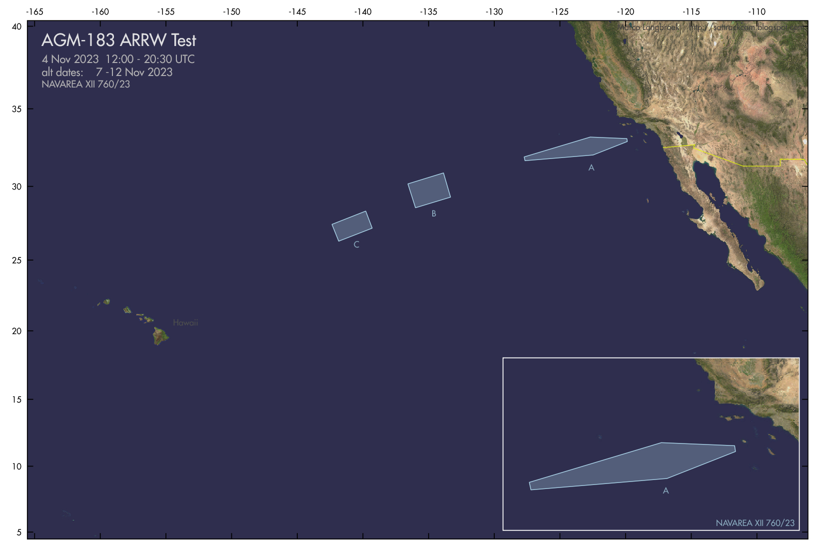 |
| click map to enlarge |
The areas are similar to earlier known or suspected ARRW tests:
 |
| click map to enlarge |
This missile must be one of the last of the (scrapped) AGM-183 program left.
Failed Minuteman-III ICBM test
Meanwhile, November 1 saw what should have been a rather routine Minuteman-III ICBM test from Vandenberg to Illegini Island, Kwajalein, going awry.
According to the Air Force Global Strike Command, an anomaly occurred and the missile was terminated in flight. A nice photograph of the launch is here.
Below is the map with the trajectory the missile should have flown, and the relevant Navigational Warnings:
 |
| click map to enlarge |
260936Z OCT 23
NAVAREA XII 749/23(18,19,81).
EASTERN NORTH PACIFIC.
CALIFORNIA.
1. HAZARDOUS OPERATIONS 01 AND 02 NOV:
A. 0631Z TO 1335Z IN AREA BOUND BY
34-40.00N 121-25.00W, 34-40.00N 120-54.00W,
34-46.00N 120-37.00W, 34-57.00N 120-37.00W,
34-58.00N 120-58.00W, 34-58.00N 121-24.00W.
B. 0631Z TO 1340Z IN AREA BOUND BY
34-19.00N 124-36.00W, 34-40.00N 124-39.00W,
34-56.00N 121-59.00W, 34-36.00N 121-56.00W.
C. 0631Z TO 1347Z IN AREA BOUND BY
32-30.00N 137-13.00W, 32-48.00N 137-18.00W,
33-04.00N 136-01.00W, 32-45.00N 135-56.00W.
D. 0631Z TO 1431Z IN AREA BOUND BY
14-36.00N 175-34.00E, 14-54.00N 175-13.00E,
14-35.00N 174-55.00E, 14-23.00N 174-49.00E,
14-17.00N 174-54.00E, 14-17.00N 175-15.00E.
2. CANCEL THIS MSG 021531Z NOV 23.//
270329Z OCT 23
HYDROPAC 3397/23(81).
NORTH PACIFIC.
MARSHALL ISLANDS.
DNC 12.
1. HAZARDOUS OPERATIONS 010700Z TO 011411Z NOV,
ALTERNATE 020700Z TO 021411Z NOV
IN AREAS BOUND BY
A. 09-53.00N 168-50.00E, 09-55.00N 168-47.00E,
09-32.00N 168-09.00E, 09-24.00N 167-35.00E,
09-09.00N 167-08.00E, 08-45.00N 167-23.00E,
09-01.00N 167-49.00E, 08-51.00N 168-22.00E,
08-54.00N 168-32.00E, 09-18.00N 169-10.00E,
09-20.00N 169-11.00E.
B. 11-08.00N 172-02.00E, 12-18.00N 171-37.00E
13-20.00N 170-42.00E, 13-28.00N 170-33.00E
13-20.00N 170-07.00E, 13-14.00N 170-00.00E,
13-07.00N 169-54.00E, 12-01.00N 170-24.00E,
11-54.00N 170-31.00E, 10-59.00N 171-14.00E,
10-52.00N 171-22.00E, 10-57.00N 171-47.00E,
10-59.00N 171-54.00E.
2. CANCEL THIS MSG 021511Z NOV 23.//
No comments:
Post a Comment