 |
| image: KCNA |
On 21 November 2023 at 13:42:28 UTC, according to the State News Agency KCNA, North Korea succesfully launched its new Malligyong-1 military reconnaissance satellite to orbit. The launch was from Sohae platform 2 using a (also new) Chollima-1 rocket.
This was the third launch attempt. Two earlier attempts, on May 31 (see this blogpost) and August 23 (see this blogpost) failed to reach orbit due to malfunctions of respectively the second and third Chollima stages.
Yesterday's sucessful launch happened 1h 18m before the window from the published Navigational Warning HYDROPAC 3667/23 (see earlier blogpost here) opened, hence taking everybody by surprise.
KCNA reports that orbit insertion was at 13:54:13 UTC.
The US Military Space Tracking network CSpOC has published orbits for two objects resulting from this launch, confirming the North Korean claim of a successful orbit insertion.
Object A (nr 58400, 2023-179A) is likely the payload, Malligyong-1, and is in a 97.43 degree inclined, 512 x 493 km sun-synchronous orbit.
Object B (nr 58401, 2023-179B) is likely the Chollima-1 upper stage and is in a 97.41 degree inclined, 512 x 467 km orbit.
The orbit of the payload is a Sun-synchronous orbit with a repeating ground track. It results in daily transits over Pyongyang around 10:00 and 22:00 local time, with a ground track that repeats itself each five days. This is consistent with a function as an optical reconnaissance satellite.
I analysed the orbital trajectory in relation to the positions of the hazard zones from Navigational Warning HYDROPAC 3667/23.
Earlier this year, in connection to the first launch attempt, there was a discussion whether:
(1) a multiple dogleg was involved, or;
(2) a direct orbit insertion with post-separation restart and dogleg manoeuvering of the second stage, or;
(3) a dogleg manoeuvre of the second stage pre-separation with insertion into a 78-degree inclined non-SSO orbit.
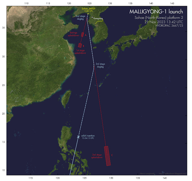
The reason for the discussion, was that the splashdown area for stage 2 east of the Philippines, was out of line with the splashdown areas for stage one and the fairings. The direction marked by the splashdown areas for the first stage and fairings would actually match a direct SSO insertion. A detailed discussion of the issue is in this previous blogpost on the May launch attempt.
We now have an answer, based on the position of the orbit at orbit insertion: a double dogleg by both the second and third stages was involved, as illustrated below:
 |
| click map to enlarge |
After separation from the first stage, stage two made a dogleg eastward. After separation from the second stage, stage three then made another dogleg westward, and next brought the payload to the orbit insertion point, the stage itself also attaining orbit in that process (where it is now space debris).
(note: the manoeuvers were likely a bit less 'sharp' than in the illustration above)
The resulting orbit is basically what would have been achieved with a direct insertion along the original launch azimuth, but with the RAAN shifted by 4.2 degrees. The double dog-leg was probably chosen to avoid the second stage falling too close to the Philippines or (in case it underperformed) on China or Taiwan.
[update] Some interesting footage has appeared on the internet from a South Korean all-sky meteor camera operated by Yonsei University. It shows the first and second stage, with the first stage blowing up after separation of the second stage. This could well have been deliberate (to avoid intact hardware recovery by South Korea: or because of range safety), but can also have been accidental (see for example how the Starship stage 1 accidentally blew up just a few days earlier). [end]
Here are a few photo's of the launch, from the North Korean State News Agency KCNA:
 | |
 |
| "Thar She Goes! No Kablooih this time!" |


No comments:
Post a Comment