Showing posts with label Sohae. Show all posts

Sunday, 26 May 2024

New North Korean launch (Malligyong-2) upcoming [UPDATED]

click map to enlarge

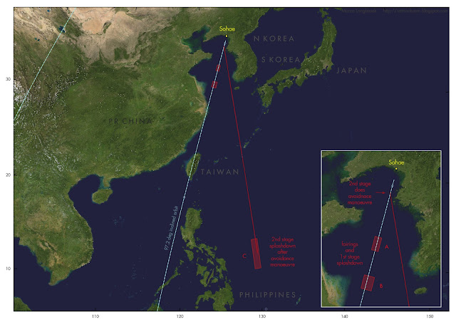
Navigational Warnings (HYDROPAC 1800/24) have appeared for a new North Korean satellite launch, the launch of their second military reconnaissance satellite Malligyong-2, from Sohae. North Korea also informed the Government of Japan of the upcoming launch.

The three hazard areas A to C  from the Navigational Warning are the same as those for the Malligyong-1 launch half a year ago (21 November 2023 - see this earlier blogpost). Quite likely therefore, the launch will go into a similar 97.4 degree inclined, 512 x 493 km Sun-synchronous orbit. Stage 2 and stage 3 will do a double dogleg.The launch window runs to June 3.

It will be interesting to see what the RAAN of the orbital plane will be in relation to that of Malligyong-1.

This is the text of the Navigational Warning:

261806Z MAY 24
HYDROPAC 1800/24(GEN).
PHILIPPINE SEA.
YELLOW SEA.
CHINA.
DNC 11, DNC 23.
1. HAZARDOUS OPERATIONS, ROCKET LAUNCHING
   IN PROGRESS UNTIL 031500Z JUN
   IN AREAS BOUND BY:
   A. 36-06.93N 123-33.12E, 35-24.52N 123-22.78E,
      35-20.02N 123-48.62E, 36-02.43N 123-59.18E.
   B. 34-05.90N 123-01.98E, 33-23.47N 122-51.88E,
      33-16.53N 123-29.67E, 33-58.97N 123-40.07E.
   C. 14-54.17N 128-40.10E, 11-19.30N 129-10.83E,
      11-26.82N 129-54.13E, 15-01.70N 129-24.05E.
2. CANCEL THIS MSG 030600Z JUN 24.

UPDATE: further speculation as to what could be the launch time in a follow-up post here.

UPDATE 2:  launch was near 13:50 UTC (May 27, 2024) and failed due to in-flight explosion of the first stage.

UPDATE 3: The North Korean State Press Agency KCNA calls the satellite in the failed launch "Malligyong-1-1" and indicates first stage failure caused the mishap, related to the "reliability" of a new LOX + petroleum engine. The wording is somewhat ambiguous on whether it concerns a new kind of rocket or a Chollima-1 stage: they do not name the rocket type, but mention a "new-type satellite carrier rocket" . 


It should be noted that during the previous Malligyong-1 launch, the Chollima-1 first stage also blew up, somewhat after separation of the second stage (so it did no harm to the payload at the time). Here is footage of that occasion.

Wednesday, 22 November 2023

North Korea successfully launches the Malligyong-1 reconnaissance satellite

image: KCNA


On 21 November 2023 at 13:42:28 UTC, according to the State News Agency KCNA, North Korea succesfully launched its new Malligyong-1 military reconnaissance satellite to orbit. The launch was from Sohae platform 2 using a (also new) Chollima-1 rocket. 

This was the third launch attempt. Two earlier attempts, on May 31 (see this blogpost) and August 23 (see this blogpost) failed to reach orbit due to malfunctions of respectively the second and third Chollima stages.

Yesterday's sucessful launch happened 1h 18m before the window from the published Navigational Warning HYDROPAC 3667/23 (see earlier blogpost here) opened, hence taking everybody by surprise.

KCNA reports that orbit insertion was at 13:54:13 UTC.

The US Military Space Tracking network CSpOC has published orbits for two objects resulting from this launch, confirming the North Korean claim of a successful orbit insertion. 

Object A (nr 58400, 2023-179A) is likely the payload, Malligyong-1, and is in a 97.43 degree inclined, 512 x 493 km sun-synchronous orbit. 

Object B (nr 58401, 2023-179B) is likely the Chollima-1 upper stage and is in a 97.41 degree inclined, 512 x 467 km orbit.

The orbit of the payload is a Sun-synchronous orbit with a repeating ground track. It results in daily transits over Pyongyang around 10:00 and 22:00 local time, with a ground track that repeats itself each five days. This is consistent with a function as an optical reconnaissance satellite.


I analysed the orbital trajectory in relation to the positions of the hazard zones from Navigational Warning HYDROPAC 3667/23. 

Earlier this year, in connection to the first launch attempt, there was a discussion whether: 

(1) a multiple dogleg was involved, or;

(2) a direct orbit insertion with post-separation restart and dogleg manoeuvering of the second stage, or;

(3) a dogleg manoeuvre of the second stage pre-separation with insertion into a 78-degree inclined non-SSO orbit. 

The reason for the discussion, was that the splashdown area for stage 2 east of the Philippines, was out of line with the splashdown areas for stage one and the fairings. The direction marked by the splashdown areas for the first stage and fairings would actually match a direct SSO insertion. A detailed discussion of the issue is in this previous blogpost on the May launch attempt.

We now have an answer, based on the position of the orbit at orbit insertion: a double dogleg by both the second and third stages was involved, as illustrated below:

click map to enlarge

After separation from the first stage, stage two made a dogleg eastward. After separation from the second stage, stage three then made another dogleg westward, and next brought the payload to the orbit insertion point, the stage itself also attaining orbit in that process (where it is now space debris).

(note: the manoeuvers were likely a bit less 'sharp' than in the illustration above)

The resulting orbit is basically what would have been achieved with a direct insertion along the original launch azimuth, but with the RAAN shifted by 4.2 degrees. The double dog-leg was probably chosen to avoid the second stage falling too close to the Philippines or (in case it underperformed) on China or Taiwan.

[update] Some interesting footage has appeared on the internet from a South Korean all-sky meteor camera operated by Yonsei University. It shows the first and second stage, with the first stage blowing up after separation of the second stage. This could well have been deliberate (to avoid intact hardware recovery by South Korea: or because of range safety), but can also have been accidental (see for example how the Starship stage 1 accidentally blew up just a few days earlier). [end]

Here are a few photo's of the launch, from the North Korean State News Agency KCNA:


"Thar She Goes! No Kablooih this time!"

Tuesday, 21 November 2023

North Korea to try a third time to launch its Chollima-1 rocket and Malligyong-1 satellite coming days [UPDATED]

click map to enlarge

UPDATE 21 Nov 2023:  

North Korea launched the satellite on 21 Nov 13:42 GMT (1h 18m before opening of the window from the Navigational Warnings!) and claims the launch was successful.


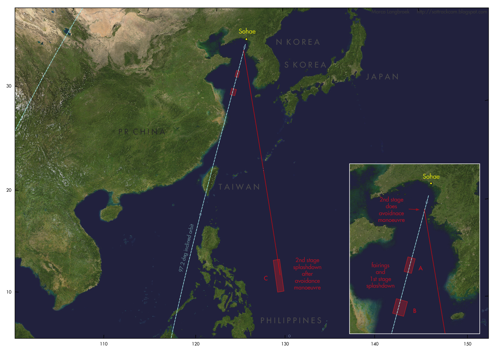
A Navigational Warning, HYDROPAC 3667/23, has appeared today that suggests that North Korea will do a third attempt to launch their new military reconnaisance satellite Malligyong-1 on their new Chollima-1 space launch vehicle the coming days, perhaps as early as to morrow 21 November.

They tried twice before: on May 31 (see this blogpost) and on August 23 (see this blogpost). During the first attempt on May 31 the second stage failed; during the second attempt on August 23, the third stage self-destructed. Maybe they will get it right this time.

The launch window runs from November 21 15:00 UTC to November 30 15:00 UTC, based on the Navigational Warning.

The locations of the three hazard areas from the Navigational Warning are similar to those for the May and August launch attempts: Areas A and B (fairings and first stage splashdown) are southwest of Sohae in the direction towards China and Taiwan, and Area C, the second stage splash-down area, is east of the Philippines. See the map above. 

As discussed before in the context of the May launch, the location of Area C suggests that a dog-leg by the second stage is involved: either before third stage release, or after.

This is the text of the Navigational Warning:

201932Z NOV 23
HYDROPAC 3667/23(91,92,94).
EAST CHINA SEA.
PHILIPPINE SEA.
YELLOW SEA.
CHINA.
DNC 11, DNC 23.
1. HAZARDOUS OPERATIONS, ROCKET LAUNCHING 
   211500Z TO 301500Z NOV IN AREAS BOUND BY:
   A. 36-02.44N 123-59.18E, 36-06.94N 123-33.11E,
      35-24.52N 123-22.78E, 35-20.02N 123-48.62E.
   B. 33-58.97N 123-40.07E, 34-05.90N 123-01.99E,
      33-23.47N 122-51.88E, 33-16.54N 123-29.66E.
   C. 15-01.70N 129-24.05E, 14-54.17N 128-40.10E,
      11-19.30N 129-10.84E, 11-26.81N 129-54.13E.
2. CANCEL THIS MSG 301600Z NOV 23.

During the previous two launches, Japan and South Korea acted ridiculously panicky, sounding sirens and telling civilians to take shelter. This is however a pre-announced space launch, not an unannounced ballistic missile launch, on a trajectory that avoids flying over significant pieces of land surface. Sounding sirens and telling people  to take shelter, is an over-reaction. Hopefully they will act less panicky this time, as this kind of panic serves no purpose.

Monday, 29 May 2023

UPDATED : North Korea announces satellite launch for May 30 - June 10

UPDATED 29 May 2023 12:00 UTC to reflect alternative orbit option

UPDATED 30 May 7:45 UTC to add comparison with 2016 launch 

UPDATE 30 May 22:00 UTC: the launch seems to have happened, around 21:30 UTC (May 30)

UPDATE 31 May: the launch reportedly failed early in flight due to a problem with the 2nd stage

(this post has been updated several times, with new pargraphs added, following development of the case. Newest paragraphs are near the bottom of the post)


According to South Korean media
, North Korea has informed Japan that they will launch a satellite between May 31 and June 11. Navigational Warnings have appeared that suggest a launch in this period as well.

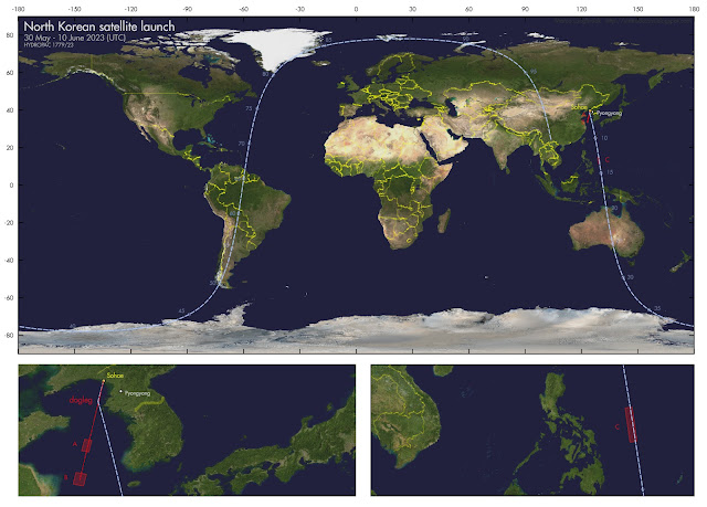
Navigational Warning HYDROPAC 1779/23 (see below) gives three hazard zones, the first two of which line up with the Korean launch site Sohae. Below is the text of the Navigational Warning in question, and a map where I have plotted the three hazard zones A, B and C and the approximate launch trajectory I reconstruct from these (numbers next to the trajectory indicate minutes after launch):
[UPDATE: but see alternative option near bottom of post, that I am increasingly inclined to]
click map to enlarge

282008Z MAY 23
HYDROPAC 1779/23(91,92,94).
EAST CHINA SEA.
PHILIPPINE SEA.
YELLOW SEA.
DNC 11, DNC 23.
1. HAZARDOUS OPERATIONS, ROCKET LAUNCHING
   301500Z MAY TO 101500Z JUN
   IN AREAS BOUNDED BY:
   A. 36-06.56N 123-33.07E, 35-24.31N 123-22.47E,
      35-20.01N 123-48.37E, 36-02.26N 123-59.11E.
   B. 34-05.54N 123-01.59E, 33-23.28N 122-51.53E,
      33-16.32N 123-29.40E, 33-58.58N 123-40.04E.
   C. 14-54.10N 128-40.06E, 11-19.18N 129-10.50E,
      11-26.49N 129-54.08E, 15-01.42N 129-24.03E.
2. CANCEL THIS MSG 101600Z JUN 23.


Note that May 30, 15:00 UTC corresponds to May 31, 00:00 local date/time in North korea, and June 10, 15:00 UTC to June 11, 00:00 local date/time. So the window of the Navigational Warning, in local North Korean date/time, matches that given by North Korea.

click map to enlarge

Areas A and B between China and Korea are likely the splashdown zones for the first stage and fairings, area C east of the Philippines is the splash-down zone for the second stage. Their relative locations point to a dog-leg manoeuver just after launch, after first stage separation and fairing ejection. First stage and fairing continue on the original launch course untill splashdown, the second and third stage, after the dogleg, insert the payload into a ~78 degree (give or take a degree or two)  inclined orbit.

The orbit is NOT sun-synchronous. It is different in orbital inclination than the orbits of the previous North Korean satellite launches: KMS (Kwangmyŏngsŏng) 3-2 and KMS 4, which are in 97.2-97.3 degree inclined orbits.


UPDATE (29 May 2023 12:00 UTC)

It was deep into the night when I originally wrote this blogpost. After a night's sleep and a discussion with Bob Christy, I am inclined towards another solution: direct insertion into a 97.2 degree inclined sun-synchronous orbit, followed by an avoidance manoeuvre of the 2nd stage after 3rd stage separation to avoid the 2nd stage falling on the Philippines:


click map to enlarge

click  map to enlarge

The location of areas A and B would fit well with this scenario. The risky part is that it means an overflight of the coastal PRC and Taiwan early in the launch trajectory. If something goes awry, this could result in hardware coming down on the PRC, Taiwan of Philippines nevertheless.

Yet this option is more and more enticing to me. The resulting orbit would be sun-synchronous, i.e. fitting an optical reconnaissance satellite, and similar to the orbits of KMS 3-2 and KMS 4. The scenario to arrive there however differs from the 2012 and 2016 launches. Here initial launch direction is into the intended orbital plane and the 2nd stage is doing a post-separation avoidance manoeuvre; whereas in 2012 and 2016, the initial launch direction was different and the 3rd stage did a manoeuver and pushed the payloads into the final orbit. The post-separation avoidance manoeuver of the 2nd stage in the current scenario would point to a (new) re-startable 2nd stage, which is interesting

The 2nd stage will splash down into a very deep part (5.7 km) of the Pacific Ocean, which makes recovery very challenging. This could be another reason why they divert it into this direction. It could be an indication that the 2nd stage is something new that they don't want to fall into the wrong hands.

If the launch is done at similar solar elevations as in 2012 and 2016, we can expect launch near 21:50-21:55 UTC, about 1.5 hours after sunrise at Sohae.

The intended orbital altitude is probably near 500 km.

Below is a very rough orbit estimate for launch at 21:50 UTC on the first available date (May 31 6:00 local time in N Korea is May 30 in UTC):


KMS 5                          for launch on 30 May 2023 21:50:00 UTC
1 70000U 23999A   23150.90972222  .00000000  00000-0  00000-0 0    06
2 70000 097.2299 155.8806 0003636 152.0900 325.4205 15.22766913    08

UPDATE (30 May 22:00 UTC):

Launch seems to have been near 21:30 UTC. here is an orbit estimate, assuming direct insertion into SSO, for launch at 21:30 UTC:

KMS 5                          for launch on 30 May 2023 21:30:00 UTC
1 70001U 23999A   23150.89583333  .00000000  00000-0  00000-0 0    06
2 70001 097.2299 150.8669 0003636 152.0900 325.4205 15.22766913    01


UPDATE 30 May 2023, 7:45 UTC:

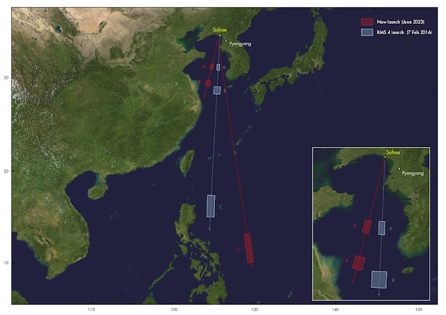
In the map below I have depicted the location of the hazard zones and (initial) launch directions for the launch of KMS-4 in 2016 (blue), and the upcoming launch (red). Note the difference in (initial) launch direction between 2016 and now, and the odd off-set chacater of area C for the current launch:
click map to enlarge


In 2016, it was the third stage that did a dog-leg to get the payload into a 97.2 deg inclined Sun-synchronous orbit. The initial launch trajectory was probably selected to minimize risk of the 1st stage falling on the PRC and the second stage falling on the Philippines:
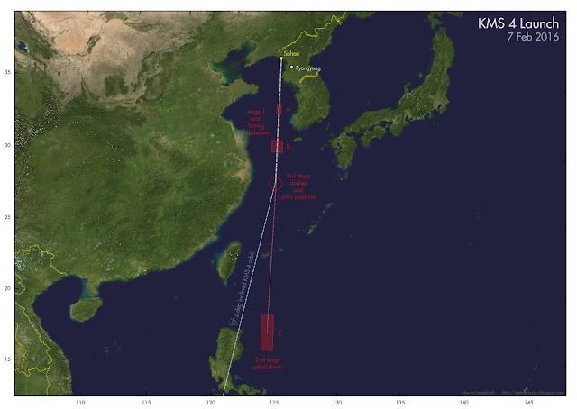
click map to enlarge

It is very clear that the upocoming launch will be according to a different scenario than the 2016 KMS-4 launch. Something odd is happening with the second stage, clearly.


UPDATE 31 May 2023: LAUNCH FAILED TO REACH ORBIT

The launch failed in flight, according to the North Korean State News Agency KCNA due to a problem with the 2nd stage. The KCNA news  report provides a launch time of 6:27 North Korean time (21:27 UTC May 30). It mentions that the launch was with a new type of carrier rocket, "Chollima-1", and gives the name of the failed satellite as "Malligyong-1".

It says that the failure was due to "losing thrust due to the abnormal starting of the second-stage engine after the separation of the first stage during the normal flight".

Yonhap reports the crash site as "200 km west" of the island of Eocheongdo. That matches well with area A, the first stage splash-down zone, from the Navigational Warnings (see map below). If the second stage failed to ignite, both the first stage and the second/third stage plus payload stack could have ended up here.

One of the stages has been recovered by South Korea, presumably from this area (photo's in this tweet thread). It seems quite intact and could be the spent first stage.
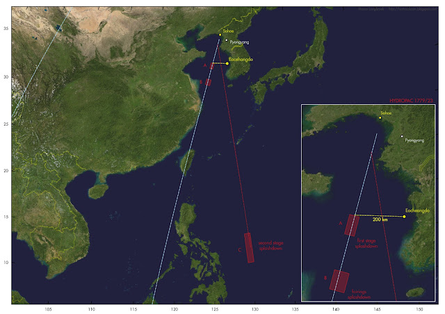
click map to enlarge

North Korea recently released images of the payload during factory testing, and already hinted at a nearby launch (see previous post here).


image: KCNA

Wednesday, 17 May 2023

Gearing up for a new North Korean satellite launch

photo: KCNA

On May 17, the North Korean News Agency KCNA and the North Korean State Newspaper Rodong Sinmun carried a news item, accompanied by photographs, of Kim Jung Un and his daughter Kim Ju Ae inspecting a new North Korean satellite in its assembly facility.

Photographs show a satellite purportedly undergoing testing. It is identified in the news items as military reconnaissance satellite no. 1, said to be "at the final stage" and "ready for loading after undergoing the final general assembly check and space environment test".

The satellite looks superficially similar to Kwangmyŏngsŏng-3 (KMS-3).  It is an oblong box with what looks to be hinged, deployable solar panels on two of its four sides. 

The satellite has been blurred on the imagery. What appears to be sensors can nevertheless be seen, albeit blurred (and perhaps the images might be in other ways manipulated).

My cautious estimate is that the satellite measures approximately 1.5 x 1.2 x 0.6 meter.


photo: KCNA

photo: KCNA

photo: KCNA

Protrusions that could be sensors can be seen, on the top and on the sides. Here are some very cautious interpretations (and I am open to other suggestions) of the blurred imagery details:

possible sensors on top (interpretation)

possible sensors on side (interpretation)


The most likely launch site will be Sohae (39.66N, 124.70 E), where previously KMS 3-2 and KMS 4 were launched from. Sohae has seen intermittent construction works the past year.

In April, North Korean State Media already announced that the country was at the verge of a reconnaissance satellite launch. Components purportedly have been tested as part of recent missile test launches, some of which featured remote sensing imagery.

This new KCNA report of Kim Jung Un visiting the test/assembly facility, is another sign that a satellite launch is probably not too far off in the future.

Most likely the satellite will be launched into a ~97 degree inclined sun-synchronous polar orbit at roughly 500 km altitude, as KMS 3-2 and KMS 4 were. KMS 3-2 and KMS 4 were launched with UNHA-3 rockets: perhaps this new satellite will be as well.

The imagery below, which I shot in September 2018, shows North Korea's satellite KMS-4 (Kwangmyŏngsŏng-4), which was launched in February 2016 and was their last satellite launch:

Sunday, 19 October 2014

Imaging the North Korean Kwangmyŏngsŏng (KMS) 3-2 satellite

Yesterday evening was initially clear. Using the SamYang 1.4/85 mm lens, I imaged an object that has been on my "to do"-list for a (too) long time: the North Korean satellite Kwangmyŏngsŏng 3-2 (KMS 3-2, 2012-072A), visible as a very faint trail on this image:

click image to enlarge

Kwangmyŏngsŏng ("Brilliant Star") 3-2 was launched under much international tension almost two years ago, on 12 December 2012, from Songhae. It is the first and so far only successful North Korean launch.

On 8 Dec 2012, just days before they launched KMS 3-2, the N-Koreans actually visited this weblog, looking for information on US IMINT satellites (specifically Lacrosse and Keyhole). As I wrote at that time, very few North-Koreans have access to the internet. Those who do, have close ties to Kim Jung Un or are among the top military. So that visit was surprising.

The reason became quickly apparent. Post-launch, I made an analysis of the KMS 3-2 launch time, showing that the North Koreans picked a carefully determined one-hour gap in Western space-based IMINT coverage to launch their satellite.

Later that month, on 21, 22 and 23 Dec 2012, the North-Koreans popped up again, visiting my launch time analysis post, and searching for TLE's of their own satellite! (one would expect that the Chinese could provide these to them, so this was surprising again). The visits came from another IP than the Dec 8 visits.

Another visit to this blog was made two weeks later, on 8 Jan 2013, from the same IP as the Dec 8 visit (but another computer perhaps, as the Dec 8 visitor used Windows Xp, but this visitor Windows 7). This time the subject of the visit was my analysis of the tumbling behaviour of the satellite which I made late December 2012 using Greg Roberts' 20 Dec 2012 footage of a KMS 3-2 pass (as it was in the dead of the Northern hemisphere winter, it was not possible for me to image the satellite myself at that time). They might have been interested in my analysis in order to assess the character of this tumbling, which was probably not intended and might indicate a failure to stabilize the satellite after orbit insertion.

Then it was quiet for 1.5 years. But last summer, I got another surprise N-Korean visit to this blog. This happened on June 9, and it was this visit which reminded me that it might be fun to try to image the satellite this summer. For various reasons, I only succeeded last night.

The June 9 N-Korean visitor visited posts about the SDS and SBSS satellite systems. The first (SDS, Satellite Data System) is a system of geostationary US military data relay satellites which (a.o.) relays IMINT data from other satellites to the US. The other (SBSS, the Space Based Space Surveillance system) is a satellite in Low Earth Orbit for detecting and tracking objects orbiting in space (i.e., other satellites - like those of North Korea).

This visit came while upgrade activities of the launch installations at Sohae were documented by the 38 North blog. The upgrade seems to point to Sohae being readied to facilitate a heavier launch vehicle. How a North-Korean interest in SBSS and SDS would fit into this picture, is however not entirely clear, apart from that it could indicate that they might aim to avoid SBSS tracking of their payloads during the initial orbit insertion.