 |
image: Wikipedia
|
EDIT (15 & 16 Apr): the launch of NROL-85 has been postponed by at least two days, 'due to technical difficulties'
EDIT (17 Apr): new launch date is 17 April 2022 13:13 UT
On 15 April 2022, at 13:41 UT (or later) according to a tweet by the NRO, SpaceX will launch NROL-85 for the National Reconnaissance Office (NRO). The launch will be from SLC-4E at Vandenberg SFB. [edit 16 Apr: launch was postponed to 17 April 13:13 UT]
NROL-85 is almost certainly a pair of NOSS satellites. NOSS stands for Naval Ocean Surveillance System; they are also known under the code name INTRUDER. If correct, the duo would become NOSS 3-9 (the 9th mission of block III). It will probably enter with the designation USA 327 in the CSpOC catalogue (with orbital elements witheld).
NOSS satellites are SIGINT satellites operated by the US Navy. They geolocate shipping on the high seas, by detecting their radio/radar emissions. They always operate in close pairs. The secondary object is usually listed (with orbital elements witheld) as "debris" in the CSpOC catalogue, but this is a ruse that fools nobody: it is a payload too that manoeuvres and keeps a careful constant close distance to the primary satellite.
Information from the launch contract tender for this launch reveals that the mission aims for a semi-major axis of 7500.5 km, an orbital eccentricity of 0.0131, an orbital inclination of 63.535 degrees and an argument of perigee of 190 degrees (i.e. perigee almost on the equator). The listed semi-major axis and eccentricity translate to a 1024 x 1221 km orbit.
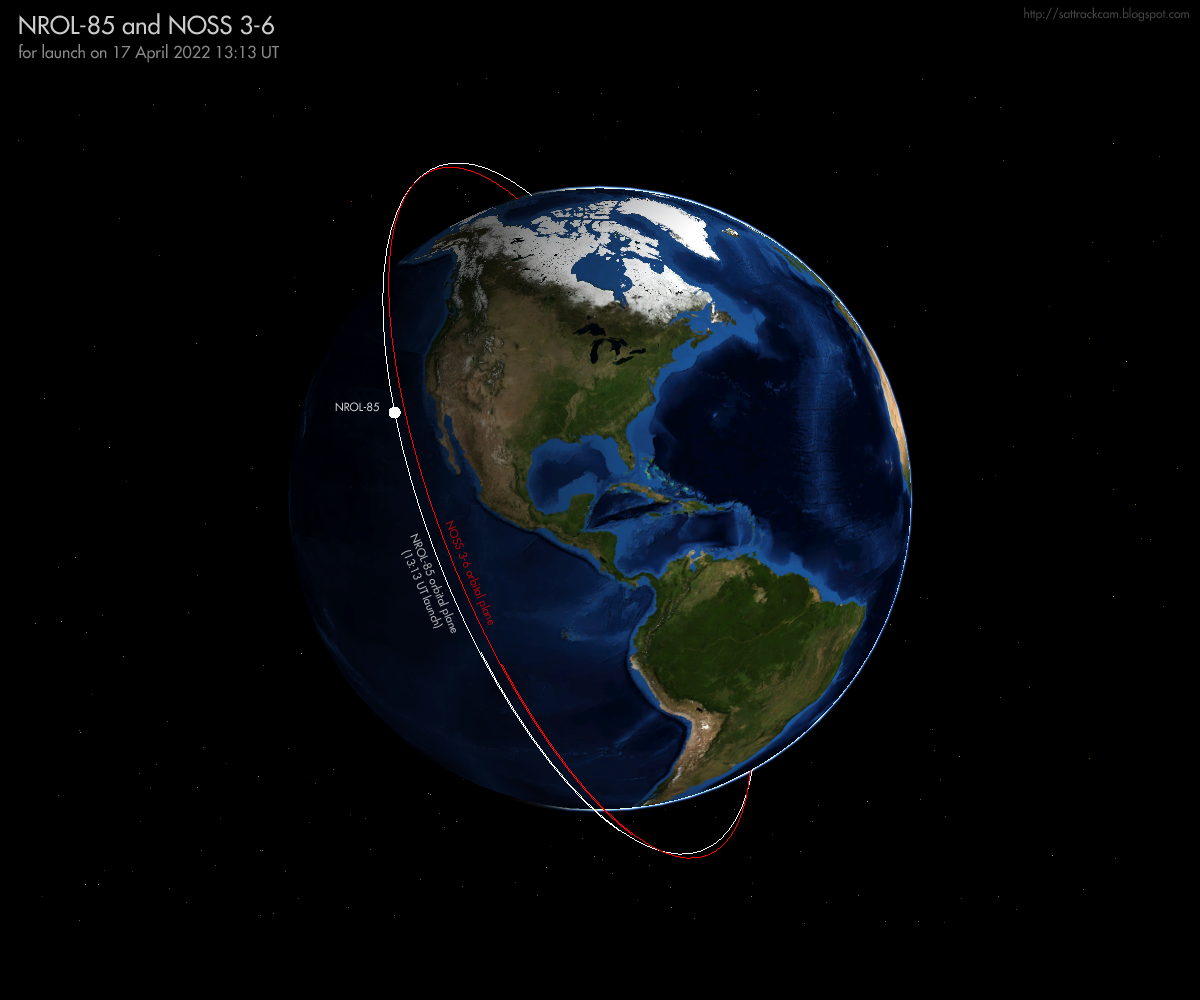
The combination of the 63.5 degree orbital inclination and 1024 x 1221
km orbit strongly points to a NOSS/INTRUDER mission. These typically have an orbital inclination of 63.4 degrees and a semi-major axis of 7485 km, values close to those quoted for NROL-85. If launch is indeed at 13:13 UT on April 17, the resulting orbital plane will be very similar to that of the existing NOSS 3-6 duo (2012-048A and 2012-048P) which was launched in 2012, as can be seen in the figure below. That also lines up with a new NOSS-launch: NOSS-pairs are typically replaced after 10 years on-orbit.
The shift in launch time with date due to the two launch postponements agree with the estimated orbital altitude and orbital plane and matches the nodal precession of a typical NOSS orbital plane.
 |
click image to enlarge
|
The Navigational Warnings for this launch (NAVAREA IV 336/22 NAVAREA XII 228/22 and HYDROPAC 987/22) define a launch direction towards the south-southeast, and agree with the 63.5 degree orbital inclination of the launch contract tender.
[EDIT: The first NavWarning has been corrected: I initially copied the wrong NavWarning for this post.....]
100706Z APR 22
NAVAREA XII 228/22(18,21).
EASTERN NORTH PACIFIC.
CALIFORNIA.
1. HAZARDOUS OPERATIONS 1150Z TO 1514Z DAILY
   15 AND 16 APR IN AREAS BOUND BY:
   A. 34-41N 120-38W, 34-39N 120-40W,
      34-28N 120-38W, 34-04N 120-17W,
      34-04N 120-05W, 34-19N 120-14W,
      34-39N 120-19W.
   B. 32-03N 118-53W, 32-01N 118-49W,
      30-51N 117-56W, 30-21N 117-39W,
      30-08N 117-47W, 30-11N 118-01W,
      30-32N 118-18W, 31-54N 118-53W.
2. CANCEL THIS MSG 161614Z APR 22.
100644Z APR 22
HYDROPAC 987/22(22,83).
EASTERN SOUTH PACIFIC.
DNC 06.
1. HAZARDOUS OPERATIONS, SPACE DEBRIS
1425Z TO 1649Z DAILY 15 AND 16 APR
IN AREA BOUND BY
20-12S 123-30W, 19-00S 119-00W,
33-48S 109-30W, 36-00S 114-12W.
2. CANCEL THIS MSG 161749Z APR 22.
I have mapped the hazard areas from the Navigational Warnings and the
resulting launch trajectory in the map below (the times listed along the
trajectory are in UT and for the updated launch date with launch at 13:13 UT (17 April):
 |
click map to enlarge
|
Based on the parameters from the launch contract tender, this is my orbital estimate, valid for launch at 13:41 UT on April 15 updated for launch at 17 April 13:13 UT:
NROL-85 for launch on 17 Apr 2022 13:13:00 UT
1 70002U 22999A 22107.55069445 0.00000000 00000-0 00000+0 0 02
2 70002 63.5350 124.8521 0131000 190.0000 291.3542 13.36458926 04
There
is an uncertainty of several minutes in pass time in this elset,
progressively so after more than one revolution, and some cross-track error is possible. But the elset should be good enough for a plane scan, taking a wide time window around a predicted pass. Be carefull not to misidentify the NOSS 3-6 duo as NROL-85. An elset for NOSS 3-6 can be found here.
If the eventual launch time turns out to be later than 13:13 UT, the elset above can easily be adjusted to match the new launch time using my "TLE from Proxy" software downloadable here.
The Northern hemisphere
will see good, fully illuminated evening passes on the day of launch and the days after it, so prospects are good for a quick on-orbit detection after launch.
The Falcon 9 upper stage deorbit is over the southern Pacific, just
after the end of the first revolution. The deorbit-burn might be visible
from south and/or central Asia.
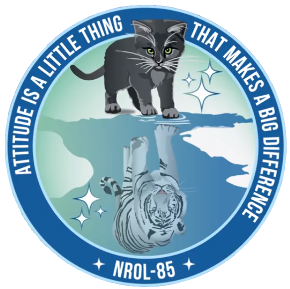
The launch patch (see top of this post) features a cat, with a tiger as its reflection. The NRO itself explains some of the symbolism in the patch in this way:
"In the NROL-85 patch, the 3 stars represent guidance, protection, and allegiance. The cat represents loyalty and devotion shared among our nation and partners. The tiger in the cat’s reflection demonstrates that while space can be challenging, a determined attitude helps NRO succeed in going"
Given that this is going to be NOSS 3-9, the 9th instance of the Block III NOSS generation, I wonder if the cat was inspired by the proverbial 'nine lives' of cats.
It is possible that a number of other small satellites will be included in this launch as a rideshare.
The NRO press kit for NROL-85 is downloadable here.
FOLLOW-UP POST HERE reporting the first observations of NROL-85 from the evening of April 17. NROL-85 might not be an INTRUDER/NOSS after all!
A SECOND FOLLOW-UP POST HERE, going a bit deeper into various speculations about what the NROL-85 payload might be.
[a small update to this post was made 13 April 2022 09:00 UT, adding a bit more background information]
[an error where I had initially copied the wrong text of a NavWarning into this post was corrected at 13 Apr 20:30 UT - many thanks to the anonymous sharp-eyed reader who noted it!]
[updated April 15 & 16 to reflect launch postponements]
[updated 17 Apr 8:45 UT with updated launch trajectory map and orbital plane diagram]