Showing posts with label manoeuvre. Show all posts

Friday, 31 January 2025

The North Korean satellite Malligyong-1 manoeuvered again, and this time it is different

click diagram to enlarge


In two contributions to The Space Review (part 1 here and part 2 here) for the first instance, as well as two follow-up blog posts for later manoeuvers (here, and here), I analyzed three periodic orbit raising manoeuvers by the North Korean military reconnaissance satellite Malligyong-1 (2023-179A) done in February, June and September 2024. They followed a similar pattern: an orbit raise (orbit maintenance manoeuver) in five daily increments, all taking place on late evening passes (13 - 14h UTC = 22 - 23h local time) passes over North Korea.

Now Malligyong-1 has manoeuvered for a fourth time. And while there are some similarities, this time the followed pattern was different.

The orbit raising manoeuver was done between 2025 January 16 and 18, a month later than I had anticipated. However, as can be seen in the diagram above, it was this time done in three daily increments, not five as was the case in previous orbit raising events. 

Compared to the previous orbit raises, the raise during each daily increment was larger, some 2.5 km per increment rather than 1.2 km as in the previous cases, for a total orbital altitude raise of about 7.5 km, which is also somewhat larger than the previous orbit raises (which was 4 km in February 2024 and 6 km in June and September 2024). As during the previous orbital altitude maintenance raises, it brought back the orbital altitude to the initial value from November 2023, when the satellite was launched. See the diagrams below:

click diagram to enlarge

The three sequential manoeuvers between January 16 and 18 raised both apogee and perigee. The daily rate of RAAN precession is still very close to the ideal sun-synchronous value.

click diagram to enlarge

As was the case for all previous orbit raises, the times I reconstruct for the three incremental orbit raises correspond to the orbital plane of Malligyong-1 passing over or near North Korea (for the method used, see here);

#   DATE       UTC    LAT     LON      ORBITS USED FOR ANALYSIS          RAISE
M1  16-01-2025 13:14  28.6 N  53.4 W   25016.48110101  25017.33556354    2.50 km
M2  17-01-2025 12:52  19.4 N  46.3 W   25017.33556354  25018.12465384    2.51 km
M3  18-01-2025 12:33  20.5 N  41.7 W   25018.45348685  25019.24307946    2.52 km


However, there is a clear difference: all nominal positions do not plot near North Korea this time, but over the mid-Atlantic. Nominal manoeuver times were about half an hour before passing over/near North Korea.

The map below plots the nominal manoeuver positions I reconstruct, as well as a part of the ground trajectory from 10 minutes before to ten minutes after the nominal reconstructed manoeuver time.

click map to enlarge

The red circle in the map is the area where the satellite would be above the horizon as seen from Pyongyang. Clearly - and unlike previous occasions - the manoeuver points do not coincide with this area, although the satellite would pass through the area about 30 minutes after the reconstructed manoeuver moments (for one of the manoeuver moments, I depicted a longer part of the ground trajectory as well with markers each 5 minutes of flight time).

The manoeuvers not conciding with the satellite being over the horizon as seen from the Pyongyang General Satellite Control Center (PGSC), is something new and intriguing. The nominal manoeuver points being over the mid-Atlantic is interesting. 

So how where these manoeuvers initiated? Assuming my reconstruction of the manoeuver points is correct, here are three options, all having their own implications:

(1) use of a pre-programmed, automated orbit raising burn;

(2) an orbit raising burn command sent through a (Russian? Chinese?) relay satellite in GEO;

(3) an orbit raising burn command sent from a groundstation or ship near/around the mid-Atlantic.

The white area depicted in the map is from where a command from a ground station or ship should have been sent in the case of option (3), possibly a location in Brazil or the mid-Atlantic. 

It might be interesting if someone better versed in that than me, could check the presence of North Korean vessels (and Russian and Chinese space tracking vessels) in the mid-Atlantic between January 16 and 18, 2025.

All three nominal positions correspond to a manoeuver just after passing through the Ascending Node, which is often a standard practise with orbit raising manoeuvers when smaller or larger alterations to the orbital inclination are required. However, no such alterations to the orbital inclination are apparent:

click diagram to enlarge

This was the fourth orbit rasing manoeuver episode since Malligyong-1 was launched on 21 November 2023. Here are they all in a table:

#  period           incr    raise    before  after    interval
1  2024 19-23 Feb    5x     4.0 km   498 km  502 km   90  days
2  2024 03-07 Jun    5x     5.7 km   497 km  503 km   105 days
3  2024 06-10 Sep    5x     5.9 km   498 km  504 km   95  days
4  2025 16-18 Jan    3x     7.5 km   496 km  504 km   132 days


A next raise might occur in the period April to June 2025. It will be interesting to see where those manoeuver locations will end up geographically and whether at some point the orbital inclination is adjusted or not.

Saturday, 14 September 2024

The North Korean satellite Malligyong-1 has manoeuvered again

click map to enlarge

At the end of the first week of September, the North Korean military reconnaissance satellite Malligyong-1 (2023-179A) made an orbit raising manoeuver again, as I predicted in June.

The raise can be seen as sudden altitude jumps at the righthand side in the diagrams below, that plot the change in the satelllite's apogee and perigee altitude over time. The first diagram shows Malligyong's orbital evolution since launch in 2023, with three orbit raising events, one in February 2024, one in June 2024 and now one in September 2024 (the gradual sinusoid trends are due to natural orbit decay and periodical evolution of the orbital eccentricity: the sudden stepped "jumps" are manoeuvers). The second diagram is a detail and shows the current September orbit raise, in five distinch daily steps:

click diagram to enlarge

click diagram to enlarge

As was the case for the orbit raising manoeuvers in February and June 2024, the raise was performed in five incremental steps, one per day. The first manoever was on September 6, the last on September 10. It raised the average orbit by 5.9 km, similar to the altitude raise in June, to 504 km (see diagram below), slightly above the initial orbit insertion altitude from the launch in November 2023. While the June manoeuvers raised both perigee (slightly) and apogee, this time only the apogee was raised, from 499 km to 511 km, a raise of 12 km (see diagrams above).

click diagram to enlarge

As a result of the manoeuver, the value for the daily RAAN precession is now slightly under, but still very close to, the ideal sun-synchronous value, with the match improving over time (se diagram above)

From the pre- and post-manoeuver orbital data, I reconstruct these five sequential nominal manoeuver times (for an explanation of how these times were determined, see my earlier analysis of the February manoevres in The Space Review of 8 April 2024):


#  DATE         UTC     LAT     LON       ORBITS USED FOR ANALYSIS          RAISE
M1 06 Sep 2024  13:12   36.9 N  137.4 E   24250.58978379  24251.57588172    1.17 km
M2 07 Sep 2024  14:24   48.6 N  122.4 E   24251.57588172  24252.49645891    1.18 km
M3 08 Sep 2024  14:01   60.6 N  133.0 E   24252.49645891  24253.21993764    1.19 km
M4 09 Sep 2024  13:43   55.0 N  134.8 E   24253.54879868  24254.20668986    1.20 km
M5 10 sep 2024  13:32   26.0 N  130.6 E   24254.20668986  24254.93046907    1.19 km


These nominal positions correspond to the crosses in the map below, with the lines showing the trajectory from 10 minutes before to 10 minutes after the nominal manoeuver time:

click map to enlarge

As can be seen, and as was the case in February and June, all manoeuver times correspond to passes within direct line-of-sight range of the Pyongyang General Satellite Control Center (PGSC) in North Korea (the red oval in the map is the geographical area where the satellite will be above the horizon as seen from Pyongyang). And as was the case in February and June, all manoevers were done on late evening passes, between roughly 13 -14 UTC (10-11 pm local time in Pyongyang).

The manoeuvers started three days earlier than I had predicted. In June, I had predicted the next manoeuver to start either Sept 9, Sept 16 or Sept 23. That was based on the time between previous manoeuvers, and the fact that these were initiated on Mondays. This time however, the series of manoeuvers started on a Friday.

We can expect the next orbit raising manoeuver to happen mid-December 2024, most likely somewhere around December 13-16, on local late evening passes (13-14 UTC) within direct range of  Pyongyang.

Monday, 15 April 2024

Manoeuver moments of the North Korean reconnaissance satellite Malligyong-1

click image to enlarge

Earlier this year, I blogged about the detection of a series of small orbit raising manoeuvers performed by the new North Korean military optical reconnaissance satellite Malligyong-1 (2023-179A). I also wrote a small piece on it for The Space Review published on 4 March 2024.

I have now completed a follow-up analysis, which appeard in The Space Review last week (8 April 2024). You can read it here.

In that follow-up analysis, I reconstructed the times and locations of each of the five small manoeuvers. And found that they match evening passes over North Korea. Read more details in the Space Review article here.

Tuesday, 27 February 2024

A perigee-raising manoeuvre by the North Korean satellite Malligyong-1

Kim Jong Un inspecting a Malligyong satellite under construction in 2023. image: KCNA

On 21 November 2023 (see this earlier blogpost), after two failed earlier attempts, North Korea launched its first military reconnaissance satellite, Malligyong-1 (2023-179A), using its new Chollima-1 rocket. 

Like two civilian predecessors (KMS 3-2 in 2012 and KMS-4 in 2016), it did indeed reach orbit - an initialy 512 x 493 km, 97.43 degree inclined Sun-Synchonous orbit. But: although North Korea in the days and weeks after launch claimed the satellite took images of various US and South Korean Naval bases and  other important locations (such as the White House), it was not clear whether the satellite was really functional

North Korea never made any purported imagery taken by the satellite public, and independent radio trackers never detected any signals from the satellite.

But now we can definitely say the satellite is alive, On February 19, 2024, it initiated the first of a number of successive perigee raising manoeuvers that stepwise brought perigee (the lowest point in its orbit) up from 488 km to 497 km. It can be seen as the stepped "jump" in the red line in the diagram below, which maps the evolution of the apogee and perigee height of the orbit since launch:

click diagram to enlarge


The orbit raise appears to have been performed stepwise, in five increments, starting on February 19/20 and completed by February 24. The net effect was not only a perigee raise, but also a more circular orbit (currently 508 x 497 km).


click diagram to enlarge


The manoeuvre proves that Malligyong-1 is not dead, and that North-Korea has control over the satellite - something that was disputed.

South Korea's Defense Minister Shin Won-sik, commenting on the North Korean satellite, just this week remarked that it: "is currently in orbit. But it is not showing any signs of performing tasks or engaging in reconnaissance activities". Thus suggesting the satellite is not working.

That remark didn't age well: while we indeed currently can not be sure whether the satellite does successfully take imagery, it at least performs orbital manoeuvres, so in that sense it is functional. And to do such manoeuvers, you need to have the satellite under control, including attitude control.

The orbit raising manoeuver comes a bit as a surprise, as the presence of an onboard propulsion system is unexpected. The previous two North Korean satellites never manoeuvered. That Malligyong-1 has means of propulsion, was not something I and many other analysts expected.

Having the capacity to raise the satellite's orbit is a big deal. It means that North Korea, as long as there is fuel left in the satellite, can prolong the satellite's orbital lifetime, by raising its orbit when it gets too low due to natural orbital decay: thus delaying reentry into the atmosphere.

The orbit raise comes at a moment that some western observers expect that North Korea will launch another satellite soon.

Monday, 14 June 2021

USA 224 has manoeuvered

During the night of June 12-13, I was doing a periodic checkup on the KH-11 Advanced Enhanced CRYSTAL satellites  USA 224 (2011-002A) and USA 314 (2021-032A) that occupy the KH-11 primary East plane. This because I expect USA 224 to manoeuvre to the secondary East plane at some point this summer, now USA 314 has recently been launched into its orbital plane as a replacement (see discussion in my earlier blogpost here).

USA 224 did not appear at the nominal time on June 13 but some 2m 20s late, indicating a manoeuvre.

Observations by David Brierley and me on June 12/13 and 13/14 have established this preliminary post-manoeuvre orbit:

USA 224                                                  255 x 998 km
1 37348U 11002A   21165.00715133 0.00014912  00000-0  12302-3 0    05
2 37348  97.8892 276.6083 0530502 157.6427 204.8870 14.81006602    06


It is clear that this is not the big plane-changing manoeuver expected, but a small regular orbit upkeeping manoeuvre: apogee was raised by some 10 km. 

From the pre- and post-manoeuvre orbit,  I calculate that the manoeuvre took place on Thursday June 10 near 14:14 UT, over the Atlantic, during crossing through the descending node and perigee. 

As usual, the manoeuvre happened while perigee was situated over the equator (when the Mean Anomaly is near 180 degrees, this is always a moment to watch out for manoeuvres). This allows to make adjustments in both orbital altitude and inclination in the same burn, with a minimum expense of fuel.

Saturday, 20 September 2014

USA 186 manoeuvered on the 17th

USA 186 being half a minute late one hour after the manoeuvre, 17 Sept 2014, 19:32:02 UT.  Chinese satellite Yaogan 11 also visible  (click image to enlarge)


Ten days after the first post-summer-glareout observations of the KH-11 Keyhole/CRYSTAL optical reconnaissance satellite  USA 186 (2005-042A), it has made another orbital manoeuvre.

In the evening of Wednesday 17 September I was targetting the satellite in a somewhat hazy sky, using the 1.4/85mm lens and a FOV near the tip of the Big Dipper tail.

To my surprise, the satellite was over half a minute late with respect to a 3-day-old element set. This suggested a  manoeuvre. My observations were corroborated by video observations of Leo Barhorst in the Netherlands and visual observations by Pierre Neirinck in France, obtained during the same pass.

The image above shows one of my images. As it turns out, this image was taken perhaps only an hour after the manoeuvre! USA 186 is overtaking Yaogan 11 (2010-047A) in the image (the fainter shorter, upper trail). Yaogan 11 is a Chinese optical reconnaissance satellite.

Observations the following evening by Cees Bassa and me in the Netherlands showed the satellite running even more late by that time: it passed 6m 32s late, low in the west. My camera caught it very close to the image edge. A few hours later, Kevin Fetter in Canada captured it as well.

The Sept 17 and 18 observations suggest that the manoeuvre happened on Sept 17, just before I did my Sept 17 observations (perhaps only an hour before, i.e. less than one revolution!). The current orbital solutions vary a bit between analysts (the post-manoeuvre observational arc is still short), but they agree in that the manoeuvre slightly adjusted the inclination, raised perigee and lowered apogee.

The new orbit is sun-synchronous and close to a 321 x 417 km orbit (it was 265 x 440 km before the manoeuvre), i.e. perigee was raised by about 55 km and apogee lowered by about 23 km. The new orbit is more circular, and starts to conform to the orbit I envisioned in October 2013. I suspect more manoeuvres gently raising perigee and lowering apogee until an approximate 390 x 400 km orbit is reached will occur over the coming half year.

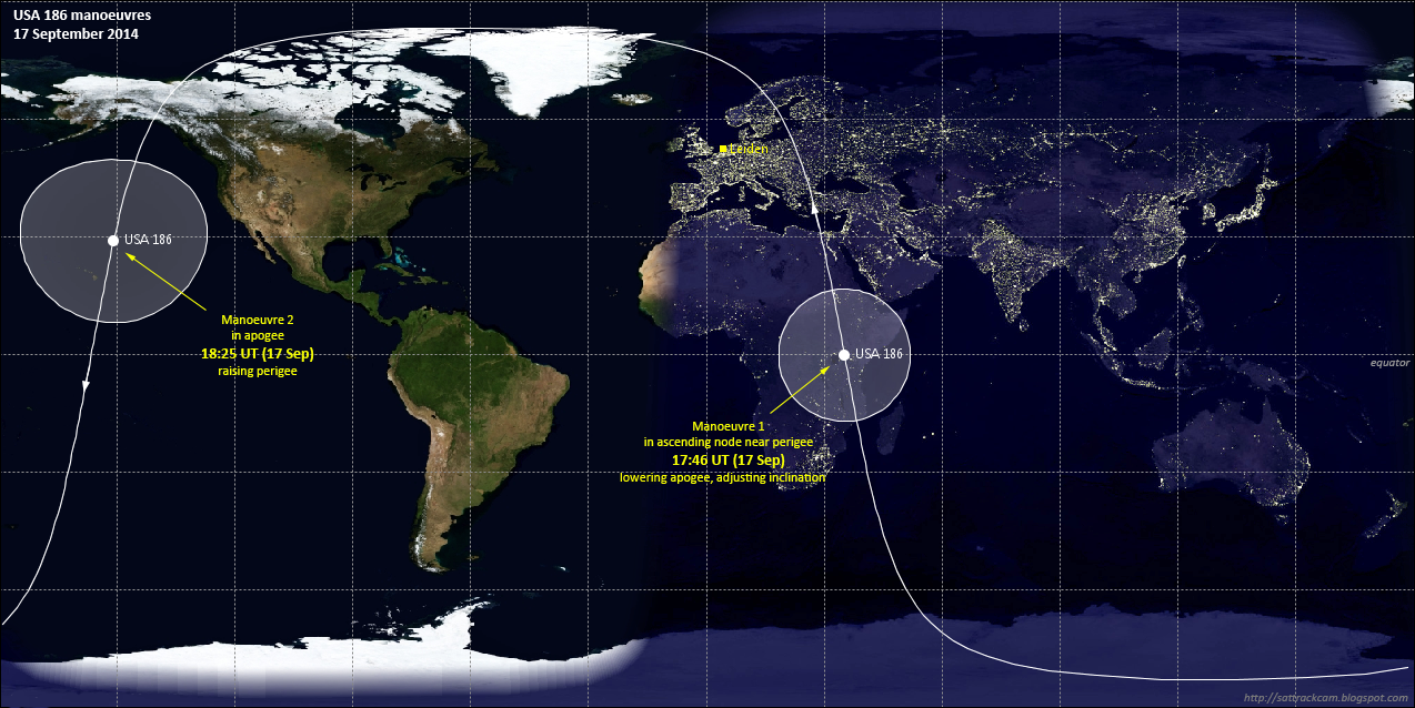
An analysis using COLA suggests the manoeuvre(s) occured on 17 September, either near 17:46 UT or 18:25 UT. Or perhaps (and I favour that) it was a double manoeuvre, performed near both of these moments.

17:46 UT corresponds to passage through the ascending node on the equator, only minutes after passing through perigee. 18:25 UT corresponds to passing through apogee.

A manoeuvre to change inclination is normally done in one of the orbital nodes, or near the poles. A manoeuvre to raise or lower perigee is normally done while the satellite passes through it's apogee, and a manoeuvre to raise or lower apogee is normally done in the perigee. If either one of these (in the current case: the perigee) closely coincides with passage through one of the nodes, this is the ideal moment to change both peri- or apogee, and the inclination in one boost, which spares fuel.

It is very difficult to  adjust the inclination, change the apogee altitude and change the perigee altitude in one manoeuvre.

My favoured scenario is therefore that a first manoeuvre happened near 17:46 UTC in or near the ascending node (and near perigee). This lowered the apogee altitude from 440 to 417 km, and allowed a slight adjustment of the inclination at the same time. Half a revolution later, while passing through apogee near 18:25 UTC, a second manoeuvre was made to raise the perigee altitude from 265 to 321 km.

(click map to enlarge)


Wednesday, 7 September 2011

USA 161 playing hide-and-seek with observers

A few days ago, I wrote about the effort to recover the KH-12 Keyhole optical reconnaissance satellite USA 161 (01-044A). After it went "missing" following August 24, and not everybody bought into the opinion that it was de-orbitted, it was recovered in the first days of September by an effort of several observers, including Pierre Neirinck and me. It had made a massive orbital manoeuvre (for more details, read here).

Following Pierre Neirinck's and my positive observation on September 1-2 already reported earlier, Björn Gimmle in Norway as well as Pierre and I failed to see it on the night of September 2-3. This could (in the case of Pierre and me) however have been due to unfavourable observing conditions at both our localities in France and the Netherlands.

Next Russell Eberst in Scotland  observed it again on September 3-4. However, on subsequent orbits it definitely got lost again. Scott Tilley in the US could not find it on September 5 and neither could Pierre Neirinck in France (I had meanwhile dropped out of the chase due to bad weather).

Next, Scott Tilley positively observed it on September 6th in an orbital position definitely out of sync with Pierre and my observations from September 1-2. This indicated that USA 161 made yet another major manoeuvre around the time of Russell's September 3-4 observation.

The situation now had gotten very confusing, with one of the analysts trying to solve the discrepancies by suggesting that Russell's observation was not USA 161 but a random stray. This is unlikely though, as any object in LEO big enough to be mistaken for USA 161 is catalogued, and Russell's object did not match any of these known catalogued objects. Moreover, as another analyst remarked, the solution to exclude Russell's observation and link our September 2-3 observations with Scott's September 6 observation, would yield very unrealistic drag parameters.

It got even more confusing for a short while, when Italian observer Alberto Rango reported a possible observation on 6-7 September, but with hesitation as he wasn't too sure. In this case, it quickly turned out to be a stray, ironically the French optical reconnaissance satellite Spot 2.

So, for the moment we have lost USA 161 again. Our observer's corps is now trying to search according to a number of possible orbital solutions, most of them no more than educated guesses. I am confident that given time, it will be found again. Given that the weather has turned bad and that the advancing winter is quickly diminishing my midnight window for USA 161 (it can now only be seen low in the north, where I have horizon obstruction), I think I am out of the chase however.

Sunday, 25 July 2010

Manoeuvring KeyHoles and the flashing Iridium 33 wreckage

July 2010 so far yielded a nice series of clear evenings, due to very warm, sunny weather (in most cases allowing observations in shorts and shirt). I observed on July 3, 4, 6, 12, 15, 16, 17 18, 19 and 22.

Two manoeuvring KeyHoles

Prime targets this month were the KH-12 KeyHoles USA 186 (05-042A) and USA 161 (01-044A). These both manoeuvred on the 14th of July, giving us observers a nice task of recovery and renewed tracking.

The manoeuvre of USA 186 (05-042A) was first noted by Pierre Neirinck in France. After some other observers missed it, he observed it being very late, but initially lost his reference points. Ted Molczan next created a number of search orbits, based on different presumed manoeuvre times. Next Alberto Rango and me again recovered the satellite (Alberto first while I still had daytime, then me on the next orbit, in deep twilight), in an orbit very close to one of Ted's search orbits.

Using pre-manoeuvre and post-manoevre orbits calculated by Ted Molczan from our observations, the manoeuvre occurred on July 14th at the ascending equator crossing at about 15:00 UTC, over Indonesia.

Next it turned out that another KH-12 Keyhole, USA 161 (01-044A) had also manoeuvred early on the 14th. Again, Pierre noted it first, observing it 12 minutes late on July 17th. Next Ted and a number of other observers joined the recovery (including me at some point). Using pre- and post-manoeuvre orbits calculated by Ted and Mike from our observations, the manoeuvre ocurred at the ascending equator crossing near 00:20 UTC, July 14th, near Hawaii.


The flashing behaviour of the Iridium 33 wreckage

On 10 February 2009, the American Iridium 33 (97-051C) telephone communication satellite and a defunct Russian satellite, Kosmos 2251, collided in space. A large number of debris pieces were spread over Low Earth Orbit (see here), and the main wreckages of the two objects kept orbiting, now wildly out of control.

The Iridium 33 wreckage (97-051C) made some fine passes last month, displaying the same kind of flashing behaviour due to tumbling that I also observed shortly after the collision in 2009 (see here, here and here). Some of these flashes are easy naked eye flashes, reaching mag. +0. The object interchanges bright flashes like these with (more numerous) fainter flashes in the +4 range.

I targetted the satellite wreckage several times this month to determine the flashing behaviour. In March 2009, it showed a period of 4.7 seconds. Analayses of the imagery of the past few nights, shows this has changed to about 3.1 seconds. Below is one of several images, taken on July 16th, showing a series of fainter and brighter flares:

click image to enlarge


Below are graphic representations of the flare positions (yellow dots) observed on consecutive nights (resp 16-17, 17-18, 18-19 and 22-23 July 2010). Please note: only flares happening during photographic exposures are shown here. There were more flares, but these happened while the camera wasn't open:

click maps to enlarge


(maps made using Heavensat)

An unusual flare was captured on July 17-18, consisting of a triple flare with flares within 0.5 seconds:

click image to enlarge


Other objects besides the KH-12 Keyholes USA 161 and USA 186, and the Iridium 33 wreckage observed last 3 weeks include:

- the geostationary objects Milstar 5, Mentor 2 and Mentor 4 (USA 202);
- the HEO objects USA 184, the USA 40 rk;
- the LEO objects Progress-M 04M, MSX, Lacrosse 5, the Lacrosse 5r, IGS 1B, the IGS 5r, USA 32, the NOSS 3-3 duo and the USA 144 decoy,;
- plus a large number of GEO and LEO strays.

I have yet to analyse the USA 144 decoy (99-028C) data from July 20 for a new tumble period determination.

Tuesday, 6 April 2010

Spring objects, a Keyhole manoeuvre and a flare of the IGS 5 rocket

After three weeks with cloudy and rainy weather, two consecutive evenings on a row finally allowed observations again on 4 and 5 April.

This is the time of the year that, like spring birds, some object re-appear from their winter hiding: the American KH-12 Keyholes, and the Japanese Intelligence Gathering Satellites (IGS).

Two KH-12 keyhole optical reconnaissance satellites were targetted the past two evenings: USA 129 (96-072A) and USA 186 (05-042A). USA 129 is of special interest these days, as it made a small manoeuvre early april raising it's orbit slightly. I captured it 8 seconds late relative to an early April elset on April 4th. An analysis of the pre- and post-manoeuvre elsets suggest the manoeuvre occurred on April 1st near 04:35 UTC while the satellite was passing the US west coast just after going through it's ascending node.

USA 129 flared to mag. 0 on April 5th, 20:05:08 UTC.

Below is an image of USA 129 rising through patchy thin clouds in Leo on April 4th, and it's sister craft USA 186 moving low in the east though Bootes on the same evening around the same time:

click images to enlarge


I also got my first images of this year of the Japanese IGS, optical and radar satellites. The defunct IGS 1B (03-009B) was imaged on April 4 and 5, and flared briefly to mag. 0 at 21:21:15 UTC on April 5 with a distinct orange colour. On April 5, the IGS 5A craft (09-066A) was imaged by me for the first time.

Below is an image of IGS 1B shot on April 4th:

click image to enlarge


I also captured the rocket from the 09-066 (IGS 5) launch: IGS 5r (09-066B). It shows flaring behaviour, as can be seen below from the photograph and the detail image, with the resulting brightness profile below that. The main brightness maximum in the image occurred at 21:44:06.9 UTC (April 5).

click images to enlarge


Saturday, 5 July 2008

Lacrosse 2 manoeuvred, and first results with the EF 50/2.5 Macro lens

Last two weeks I took several images in order to calibrate the timing of the new Canon EOS 450D camera. I finished the calibration just in time to catch positions of the SAR satellite Lacrosse 2 (91-017A), which manoeuvred twice last week. As usual, this happened with perigee on the equator.

The new Canon EF 50/2.5 Macro lens arrived as well. As promised by my friends who recommended it, it is a superb lens not only for macro photography, but also for astrophotography.

(click images to enlarge)


Above are two examples of images I shot with the lens: one macro image of a seven-spotted ladybird (Coccinella septempunctata) on lavender in the Cospar 4353 garden; and an astrophotography result, obtained from Cospar 4353. The latter shows the area around Deneb in Cygnus, including the North America nebula. It is the result of a 'stack' (digital sum) of 98 individual exposures of 10s each (mimmicing a 16m20s exposure).

Combined with an ISO 800 setting on the camera, the EF 50/2.5 Macro goes much deeper than my previous Ixus camera's did, catching fainter objects. Last Tuesday and Wednesday nights, this was immediately apparent from the number of strays catched during satellite photography and a short astrophotography session.

(click image to enlarge)


The lens (with 50 mm and a factor 1.6 equivalent to an 80 mm lens on an analogue camera) has about 25 degrees FOV, which is a 50% smaller FOV than I previously used, so pointing the camera correctly needs more attention. But the results are superb. On the stars, I get astrometric standard deviations of only 5" (5 arc seconds) typically. The satellite positions have a larger uncertainty, as they are also influenced by the timing accuracy.

The amount of noise produced by the EOS 450D sensor is much less than that by the Ixus camera's, and that pays off. While (unlike the Ixus) the camera does not standardly employ a noise reduction routine (which with the Ixus I suspected to sometimes "eat" part of the trails), the satellite trails stand out much better in the background, with less ambiguity as to where the trail ends.

Below are two images of last night: a single shot of Lacrosse 2 (91-017A), and a stack of two images taken shortly after each other. Relative to the pre-manoeuvre orbital elset (epoch 08177.99486268) the sat was 35 seconds early last night, on June 30 it was 2 seconds.

(click images to enlarge)


Tuesday, 5 February 2008

Lacrosse 2 manoeuvred again (updated)

Yesterday evening was very clear. While looking up some deep-sky objects and while waiting for target satellites to appear, I saw several faint strays.

Lacrosse 2 (91-017A) was 21.6s early and 0.16 degree off-track relative to a week old elset 08027.82795435. Hence, just like early January, it appears to have manoeuvred again.

Update: Russell Eberst's data of the same pass confirm my observation. From a very preliminary analysis I did, it seems that the manoeuvre entails a similar mean motion change by about +0.0005 as was the case early last month.

Other objects observed this evening were the ELINT sat USA 32 (88-078A) and the NOSS 3-2 duo (03-054A & C). In addition, I observed the International Space Station making a pass through Taurus just beneath the Hyades and Pleiades. I had not realised the decoupled Progress M-62 would be following it closely, so I missed that one (it also was just too far behind ISS to show up on the photograph I shot, see below).

(click image to enlarge)


It was overcast this morning so again no chance to observe USA 193. It is still overcast, so I am going to miss both the old and new Progress (the latter launched today) tonight. I hope it clears in time to observe them and the Space Shuttle STS-122 that is scheduled to launch next Thursday.

Sunday, 13 January 2008

Lacrosse 2 manoeuvre, and bad luck with a stopwatch

Yesterday was a very clear day, so in twilight I set up the ETX-70 to gather positional data on Lacrosse 2 (91-017A), the NOSS 3-3 (05-004 A & C) duo and the NOSS 3-4 (07-024A & C) duo.

I had adapted the home-made piggyback camera adapter slightly, so it can also funtion as a rest for my 5 mw green laserpointer. The drawback of the ETX-70 is that it doesn't come with a finderscope, so I use the laser to point the telescope. A 5 mw green laser gives a tens of meters long visible beam at night pointing to where you point the scope if you shine it parallel to the scope tube. Simple, and works like a charm.

Unfortunately, after succesfully observing passes of NOSS 3-3 A & C and Lacrosse 2 I must have hit a wrong button on the stopwatch by mistake. When I had pointed the telescope to the point near where NOSS 3-4 A & C should pass and took up the stopwatch, I discovered to my horror that it was no longer running and had no lap times in it's memory! I lost all gathered points so far.

Next, in the confusion of having to start up the stopwatch anew just before the NOSS 3-4 duo pass, I lost that pass.

Now, I can't quite stand such things happening, it makes me very irritated for a while. Luckily my neighbours have double-pane glass, so probably they did not hear my swearing...

What saved the night was that before turning to the telescope, I had triggered the Ixus camera in addition during the Lacrosse 2 (91-017A) pass. The trail showed up faint but well enough defined to measure against the late twilight sky, which meant I had an image providing two positions.

After data reduction, it turned out that the satellite was 17.3 seconds early relative to Mike's 07357.17849791 TLE. On the 6th of January, the difference to this TLE was 1 second. So I reckoned 91-017A must have made a manoeuvre recently. Which, it turns out, it indeed did, a small manoeuvre changing the mean-motion slightly on or near the 6th. What I had missed was that Mike had just issued and update of the 91-017A orbit incorporating the manoeuvre yesterday morning.
That 91-017A still does manoeuvre, points out it is still alive and probably still being used for reconnaisance almost 17 years after it was launched.

(click image to enlarge)


Lacrosse 2 (91-017A) crossing through Cygnus 17.3 seconds early

I set my alarm-clock to see if it would still be clear in the morning (allowing me in that event to catch amongst others Progress M-61). But alas, it had become overcast.