Showing posts with label X-37B. Show all posts

Sunday, 24 August 2025

X-37B OTV 8 and Limasat (the USSF-36 payloads) imaged


This morning (early 24 August 2025) weather finally cooperated and I managed to observe both of the USSF-36 payloads, two days after launch: the X-37B Spaceplane OTV 8 (2025-183A) and  LIMASAT (2025-183B). Limasat was about half a minute in front of OTV 8.

Above is footage from this pass, showing both objects. The footage was obtained from my home in Leiden, the Netherlands, using a WATEC 902H2 Supreme camera with a Samyang 1.4/85 mm lens filming at 25 frames/second. This was an early twilight pass low in the south-southwest (27 degrees maximum elevation).

Below are framestacks from parts of the footage (both framestacks are 51-frame stacks):

Limasat (stack of 51 frames)

 
X-37B OTV 8 (stack of 51 frames)


Current observations show OTV 8 in a 331 x 342 km, 49.5 degree inclined orbit. Limasat is in a 330 x 341 km, 49.5 degree inclined orbit. Limasat was probably carried piggyback on the X-37B Service Module before being released.

Saturday, 23 August 2025

X-37B Spaceplane mission OTV 8 located on orbit

OTV 8 imaged by Kevin Fetter 5 hours after launch. Image (c) Kevin Fetter, used with permission

OTV 8, the 8th mission of the US Space Force's X-37B Spaceplane, launched on 22 August 2025 at 03:50 UTC. It has been catalogued as 2025-183A (cat. nr. 65271) under the name of  'USA 555', along with a second payload, called LIMASAT (2025-183B, 65272). The latter has probably been dispensed from the OTV 8 service module.

Five hours after launch, Kevin Fetter managed to observe OTV 8. Above is one of his images, showing OTV 8 as a short bright trail in a partly cloudy sky. 

A preliminary orbit fit suggests that OTV 8 is in a 327 x 334 km, 49.5 degree inclined orbit [update 25 Aug 2025: the latest improved orbit update shows it in a 331 x 342 km, 49.5 degree inclined orbit]: a slightly (~20 km) lower orbital altitude than my initial pre-launch guess but otherwise a quite comparable orbit.

Click image to enlarge


An overview of the OTV missions so far: 

MISSION  ORBITER  LAUNCH   INCL   ORBIT   DURATION
--------------------------------------------------
OTV 1    I        2010     40.0   LEO     224 days
OTV 2    II       2011     42.8   LEO     468 days
OTV 3    I        2012     43.5   LEO     674 days
OTV 4    II       2015     38.0   LEO     717 days
OTV 5    II       2017     54.5   LEO     780 days
OTV 6    I        2020     45.0   LEO     909 days
OTV 7    II       2023     59.1   HEO     435 days
OTV 8    I        2025     49.5   LEO         tbd
--------------------------------------------------

Bad weather in the Netherlands has so far precluded me from trying to observe the latest launch.
 

EDIT (24 August 2025): 

I imaged both the USSF-36 payloads (OTV 8 and Limasat) in the early morning of 24 August, see this follow-up blogpost with footage. 

Sunday, 17 August 2025

The upcoming launch of the X-37B Spaceplane mission OTV 8

X-37B mission OTV 6 after landing (Image: US Air Force)

Navigational Warnings have appeared for OTV 8, the 8th launch of the secretive X-37B spaceplane by the US Space Force (launch USSF-36). The launch, on a SpaceX Falcon 9, will be from Cape Canaveral launch pad 39A. The window of the Navigational Warning runs from 22 to 28 August 2025, with a time window of 08:30 - 10:30 UTC 03:40 - 08:03 UTC for August 22 (August 21 local date in Florida). There is something odd with these times by the way, on which more later.

Navigational Warnings NAVAREA IV 877/25 and HYDROPAC 2096/25 define two hazard zones. One is the immediate launch hazard zone on the Florida coast. The other is the deorbit area for the Falcon 9 upper stage, in the Eastern Pacific, near the end of the first revolution. 

While the direction of the first hazard zone on the Florida coast suggests a 42 degree inclined orbit, the location and direction of the Falcon 9 upper stage deorbit area is incompatible with this. Rather, it fits a 49.5 degree inclined orbit. The location and the time difference of the deorbit window start compared to that for the launch area, strongly point to launch into a Low Earth Orbit, with an orbital altitude likely near 350-400 km, just like the first six missions (remember that mission OTV 7 surprisingly was sent into a Highly Elliptical Orbit, see several previous posts, e.g. here).

I have plotted the two hazard zones and a launch trajectory for a 49.5 degree inclined, ~350 km altitude orbit in the map below. Numbers next to the trajectory refer to the flight time in minutes after launch:


Click map to enlarge


Below are the two Navigational Warnings:

142327Z AUG 25
NAVAREA IV 877/25(11).
NORTH ATLANTIC.
FLORIDA.
1. HAZARDOUS OPERATIONS, ROCKET LAUNCHING 
   220340Z TO 220803Z AUG, ALTERNATE
   230400Z TO 230823Z, 240420Z TO 240843Z,
   250440Z TO 250728Z, 260500Z TO 260748Z,
   270345Z TO 270808Z AND 280540Z TO 280833Z AUG
   IN AREA BOUND BY
   28-40.25N 080-38.57W, 28-50.00N 080-22.00W,
   28-39.00N 080-11.00W, 28-27.24N 080-31.58W.
2. CANCEL THIS MSG 280933Z AUG 25.


141931Z AUG 25
HYDROPAC 2096/25(83).
PACIFIC OCEAN.
DNC 06, DNC 13.
1. HAZARDOUS OPERATIONS, SPACE DEBRIS
   220500Z TO 220911Z, 230520Z TO 230931Z,
   240540Z TO 240951Z, 250600Z TO 250836Z,
   260620Z TO 260856Z, 270505Z TO 270916Z
   AND 280700Z TO 280941Z AUG 
   IN AREA BOUND BY
   09-55.00N 120-25.00W, 10-41.00N 121-25.00W,
   07-44.00S 135-45.00W, 08-30.00S 134-45.00W.
2. CANCEL THIS MSG 281041Z AUG 25.


Note the shift in launch time with date: 03:40 - 08:03 UTC for the 22nd, 04:00 - 08:23 UTC for the 23rd, etcetera: a shift forward in time of 20 minutes per day. [edit: as noted by Ted Molczan, the times next suddenly shift to - nearly - the initial times again by August 27. I still cannot make sense of it]

The direction of this shift is odd. It is forward, to a later time each day: if a particular orbital plane is aimed for, it should however shift backwards, to an earlier time, each day. I wonder if this is a mistake and someone added corrections into the wrong direction...

The X-37B spaceplane (there are actually two of them) is the subject of a lot of conjecture and wild tales. My interpretation is that it is a technology testbed, not some space weapon such as the Russians and Chinese would have it. 

The rumoured "high manoeuverability" is often misunderstood: in flight, the X-37B does not change its orbital plane (see this earlier post from 2019). It does change orbital altitude frequently, and during the last mission (OTV 7) into HEO, it used Aerobraking (briefly dipping into the upper atmosphere during perigee) near the end of its mission to reduce orbital speed and altitude in preparation for landing. It manoeuvered almost daily during that mission. However, and I want to re-emphasize this as it is a common misunderstanding, it does not swirl and manoeuver like an X-wing Starfighter or Tie-fighter, changing orbital plane at will. In many ways, on-orbit it is just another satellite, moving in a fixed orbital plane (this is how we trackers find it back after an orbit raising or lowering manoeuver: we do a plane scan). The wings only function in the atmosphere, not in space.

According to this Space Force bulletin, mission OTV 8 will experiment with laser communications with "proliferated commercial satellite networks in Low Earth Orbit" (read: Starlink). It will also test a new navigation device, a "quantum inertial sensor" which works by "detecting rotation and acceleration of atoms without reliance on satellite networks like traditional GPS". This experimental technique is important to be able to continue navigating in space when GPS is being jammed/spoofed, and will become an important means of navigation in XGEO (CisLunar Space) in the future.

Thursday, 10 October 2024

X-37B Spaceplane OTV 7 to lower orbit by aerobraking

X-37B OTV 7 near apogee  imaged by the author on 3 October 2024. Click to enlarge

It looks like the time on orbit is about to end for mission OTV 7 of the enigmatic US Space Force X-37B spaceplane (2023-210A). Launched on 29 December 2023, it went into an unusual Highly Elliptical Orbit with apogee near 38 600 km and perigee near 300 km and an orbital inclination of 59 degrees (see various earlier blogposts).

On October 10, the US Space Force announced that OTV 7 "will begin executing a series of novel maneuvers, called aerobraking, to change its orbit around Earth and safely dispose of its service module components in accordance with recognized standards for space debris mitigation"

I already wrote earlier, e.g. in this blogpost from February, that the mission likely would end by using aerobraking in perigee to lower apogee, circularize in a Low Earth Orbit, and then land. 

Aerobraking is a technique where, by a manoeuver in apogee, the perigee altitude of the orbit is lowered such that it is in the top of the atmosphere: not low enough to make it reenter, but enough to significantly slow it down. When the spacecraft goes through perigee in that situation, it experiences enhanced drag, that will result in drastically lowering the apogee of the orbit, certainly after a few of such perigee passages. 

This will bring the orbit down and eventually change the Highly Elliptical Orbit character into a Low Earth Orbit. Orbital velocity near perigee (over 10 km/s while in a Highly Elliptical orbit with apogee near 39 000 km) will be drastically reduced (to 6.8 km/s) by this, allowing the vehicle to reenter the atmosphere and land without experiencing too excessive forces during reentry.

It looks like the process of lowering perigee might already have started around October 4, when for the first time perigee (while earlier just above 300 km) seems to drop below 300 km:

OTV 7 apogee and perigee altitudes over time. NOTE: logarithmic Y-axis! Click to enlarge


This is difficult to say for certain, as frequent larger and smaller manoeuvers by OTV 7 (it seems to have manoeuvered daily, as it never was on the ephemerids during a next observation) combined with a sketchy observational coverage (most of the observations from the last two months have been done by me, with some by Tomi Simola), means that orbit determinations are not always that easy and it is not clear how real the minor variations in perigee altitude from orbit determination to orbit determination are.

The wording of the US Space Force news item is such, that it seems to suggest that after apogee lowering and orbit circularization through aerobraking, OTV 7 might for a while continue its mission in a lower (Low Earth) orbit, as they write:

"Once the aerobrake maneuver is complete, the X-37B will resume its test and experimentation objectives until they are accomplished, at which time the vehicle will de-orbit and execute a safe return as it has during its six previous missions".

So rather than land directly after the aerobraking sequence is finished, it might stay on orbit for days, weeks or months, in an orbit that is more like those of previous X-37B missions.

Over the past two months, perigee has been kept on the equator (argument of perigee kept near 180 degrees). That is a situation where during a perigee pass, there is the possibility to change the orbital inclination. So it is possible that near the end of the aerobraking sequence, the orbital inclination (currently 59 degrees) will be changed to a lower value, e.g. around 40 degrees as with previous X-37B missions in LEO.

As an interesting aside, the US Space Force bulltein also mentions that mission OTV 7 in its unusual HEO orbit "has conducted radiation effect experiments and has been testing Space Domain Awareness technologies in a Highly Elliptical Orbit".


X-37B spaceplane. Image: US Space Force

Sunday, 18 August 2024

More X-37B spaceplane OTV 7 observations

OTV 7 imaged on August 11. Click image to enlarge

In a previous blogpost I wrote about recovering the X-37B Spaceplane OTV 7 (2023-210A) on July 30. I have now observed it a couple of times, at intervals of a few days due to a combion of weather conditions and favourable or less-favourable pass times. Above is an image from August 11. The diagram below shows where it was in its orbital position at that time, coming down from apogee:


click image to enlarge


Between mid-March and end-of-July, OTV 7 had brought down its apogee by a few thousand kilometers. Since recovery on July 30, it is continuously making smaller manoeuvers as well (currently, it seems to make small orbit raising manoeuvers adjusting both apogee and perigee). As a result, it is invariably off predictions (usually being a bit 'late') and a small plane scan is necessary to recover it. Having a wide-field instrument (the FOV of the instrument I currently use, an ASI 6200 MM PRO with 1.2/85 mm lens, is 24 x 16 degrees) is useful in this aspect.

The brightness of OTV 7 strongly depends on where it is located in its orbit during observation (as well as, of course, phase angle and condition of the local sky). When it is in or near apogee, it is fainter and the trail is short.

When following the object over (a part of) a pass, the brightness and apparent angular rate of movement (trail length) notably changes. How clearly it can be seen in the imagery is complex interaction of actual brightness, apparent angular movement (when it moves faster, each image pixel is illuminated less), range to the observer and phase angle.

Below are two images from the night of August 14-15, some 3 hours after OTV 7 passed apogee. The second of these images shows OTV 7 not far from M31, the Andromeda galaxy. Even though the two images are not at the same image scale (the one with M31 is reduced in size, to show a wider FOV), the difference in trail length after a mere half an hour can already be seen (both images are 10-second exposures with a ZWO ASI 6200 MM PRO and Samyang 1.2/85 mm lens).


Sunday, 4 August 2024

Recovery of the X-37B spaceplane OTV 7

click to enlarge


The classified US Space Force X-37B spaceplane OTV 7 (2023-210A) was launched on 29 December 2023, in an unusual Highly Elliptical Orbit. Five weeks after launch, in the first week of February 2024, it was found on-orbit by Tomi Simola from Finland in a 38600 x 300 km, 59.15 degree inclined orbit (see this earlier blogpost). We followed it for a month and then lost it: the last observation was on March 15.

But now it has been recovered! On the night of July 30-31, I was imaging geosynchronous objects when I noted a short trail made by an unidentified interlooper.  Mike McCants identified the UNID as OTV 7.

The image in top of this post (one out of four images spanning half an hour) shows the short faint trail created by OTV 7. The ~9 by 4.5 meters large X-37B spaceplane was near apogee of its orbit at that time, at about 35535 km altitude (and a range of some 38775 km to my observing location). The image is a 10-second exposure with a ZWO ASI 6200 MM PRO and Samyang 1.2/85 mm lens, and shows only a small part of the original image. It was taken from Leiden, the Netherlands.

Weather next initially conspired against me, but last night, August 3-4, I again observed it, some 25 minutes late on the initial elset estimate. This is a small part of one of the images, shsowing the faint trail created by OTV 7:

click image to enlarge

The observing conditions were very dynamic this time: after rainshowers, small but bright, stamp-sized clearings were sometimes present in the clpud cover. I managed to image the object through such gaps in the cloud cover a few times over an half-an-hour-period, 25 minutes late on the preliminary orbit. 

Below is an example of what I am talking about when I say "stamp-sized clearings": this is the last image (reduced in size as the true image is 9576 x 6388 pixels) on which I could find it. All the white is clouds....:

click to enlarge


The new observations constrain the orbit a little bit better: 314 x 35552 km, 59.15 degree inclined. A provisional elset:


OTV 7
1 58666U 23210A   24216.90625742 0.00000000  00000-0  00000+0 0    01
2 58666  59.1511 329.1636 7247171 178.5736 186.3429  2.29027449    03

rms 0.004 deg   from 9 obs, arc July 30.96 - Aug 3.96 UTC


Below is a comparison between the (forward propagated) orbit from March (red), and the current orbit (white). Apogee is some 2300 km lower than it was in March (and this is not due to natural orbital decay, but due to manoeuvering). The orbital plane itself is still similar.


click image to enlarge

Tuesday, 13 February 2024

Imaging the X-37B robotic spaceplane mission OTV 7

OTV 7 imaged from Leiden at 12 Feb 2024. Click image to enlarge

In my previous post, I wrote about the first on-orbit detections, by Tomi Simola, of the US Space Force's X-37B space plane mission OTV 7, and how it is in an orbit that is certainly unusual for a space plane.

Yesterday (February 12, 2024) I finally had a clear sky, and an almost near-zenith pass of OTV 7 in the early evening just after twilight. So I could finally image it too

Using the ZWO ASI 6200MM PRO with a 1.2/85 mm lens, OTV 7 showed up well in the imagery, as a reasonably bright object that was not difficult to detect. Above is one of the images, a 10 second exposure near 19:06 UTC while OTV 7 was over Europe at ~6700 km altitude, descending towards perigee.

The orbit is now a bit better constrained, and about  38600 x 300 km at 59.15 degree inclination. Perigee is currently over the equatorial region. The image below shows the orbit, and the orbital position of OTV 7 around the time I imaged it:


click image to enlarge

OTV 7 was several minutes early on one day old elements, meaning it appears to be actively manoeuvering. This fits an X-37B, the previous OTV missions (all to LEO) were also frequently manoeuvering. 

It is possible that the spacecraft is using a continuous thrust ion engine.

In the current Highly Elliptical Orbit (HEO), the orbital velocity at perigee is close to 10.2 km/s, which is 2.4 km/s more than in a Low Earth Orbit (previous X-37B missions all went to Low Earth Orbit). To eventually land the spaceplane, the orbit likely will be circularized first, by lowering apogee drastically, perhaps with the help of aerobraking in perigee, before doing a deorbit and landing.

This is my current orbital fit, which is still up for improvement, based on observations by Tomi Simola, Eelke Visser, Scott Tilley and me:

OTV 7
1 58666U 23210A   24044.12782730 0.00000000  00000-0  00000+0 0    05
2 58666  59.1696   4.0545 7416334 167.8228 233.0020  2.09261279    07

Saturday, 10 February 2024

X-37B OTV 7 has been found in HEO!


OTV 7 discovery image by Tomi Simola, Finland  ((c) Tomi Simola, used with permission)

On 29 December 2023 at 1:17 UTC, after several delays, SpaceX launched a Falcon Heavy for the US Space Force with OTV 7, the seventh X-37B Spaceplane mission. Now its payload has been found!

OTV 7 was the subject of much speculation. The use of a Falcon Heavy, and the locations and time windows of related rocket stage splash-down and reentry zones, as well as statements by the US Space Force, indicated it might go into a different, higher altitude orbit than the previous six missions. On this blog, I speculated about a ~74-degree inclined Highly Elliptical Orbit (HEO).

Thanks to the dedicated efforts of Tomi Simola from Finland, OTV 7 has been found on-orbit this week. It is indeed in a HEO orbit, but inclined by 59.1 degrees, not 74 degrees.

Tomi performed a dedicated plane scan using a fixed staring camera. On the night of 7-8 February, he finally nabbed the elusive payload (see the discovery image above), while it was at ~3400 km altitude descending towards perigee. He used a WATEC 902H2 Ultimate camera with a 1.2/50 mm lens and 10 seconds integration.

Subsequent observations show that OTV-7 is in a 38840 x 323 km, 59.1 degree inclined Highly Elliptical Orbit. Perigee is just North of the equatorial region (currently clearly North of it near latitude 30 N, but short after launch it was at a lower latitude near 15 N).

(a Highly Elliptical Orbit (HEO) is an orbit with a low perigee - generally at a few hundred km altitude -  and distant apogee, at 35 000 km altitude or more. As a result, the shape of the orbit is highly elliptical (highly elongated). An object in HEO typically makes two orbital revolutions a day. Due to the shape of its orbit, it spents most of its time in the higher parts of the orbit and a relatively small amount of time near perigee. When apogee is over high latitudes, as is usually the case for these orbits, this allows a long dwell-time over these latitudes with view of a very large area (a full hemisphere when in apogee). HEO orbits are hence the polar equivalents of a GeoSynchronous Orbit (GEO) and often used for communications relay or long-term monitoring of areas. They are a favoured orbit for Communications, SIGINT and Infra-Red missile launch monitoring. The OTV 7 HEO is unusual in that perigee is not over the southern hemisphere).


orbit of X-37B OTV-7 as of 10 Feb 2024. Click to enlarge


The observed orbital plane of the object matches well with a launch from Cape Canaveral on 29 December 1:07 UTC. Together with the fact that the orbit is quite unusual for a HEO object with it's Northern hemishere perigee location, an identification with OTV 7 is very likely.

Propagating the orbit backwards, the suggestion is that, after initial launch into a 51.5 degree inclined low coasting orbit, it was pushed into HEO by a manoeuvre when crossing the descending node, about half a revolution after launch. It subsequently probably manoeuvered a couple of times, adjusting apogee and perhaps also inclination. 

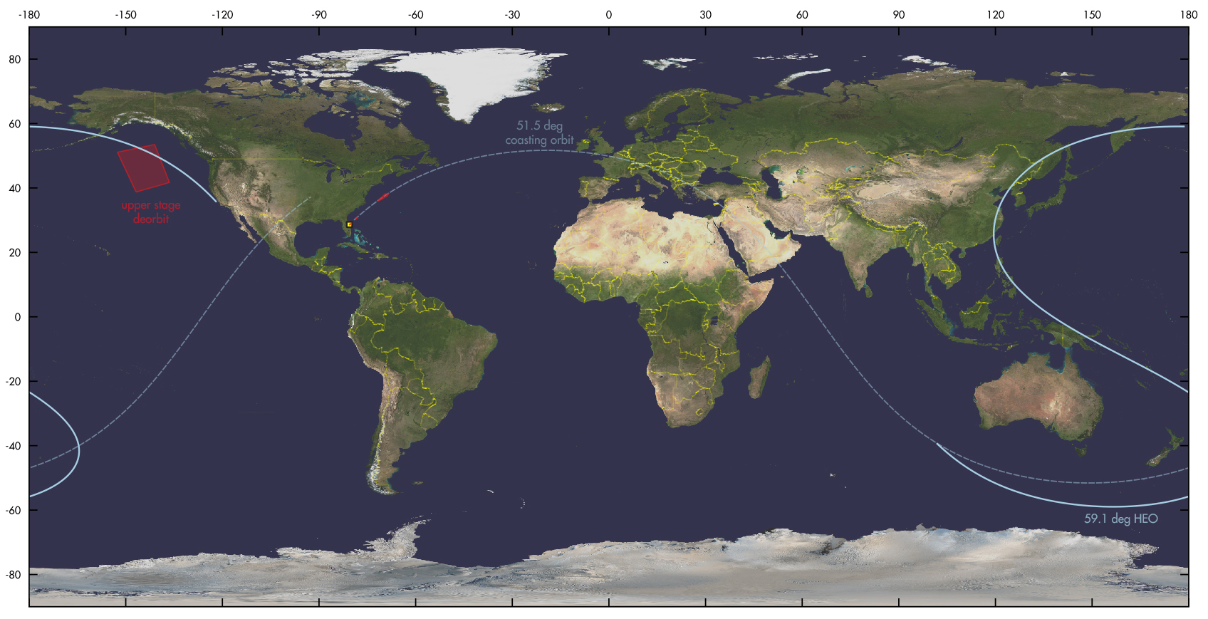
The upper stage probably did a second manoeuvre after payload separation, changing its inclination to 74 degrees as suggested by the shape, orientation and location of the deorbit area from the Navigational Warnings related to the launch.

click map to enlarge

The map above plots the current orbit of OTV 7 propagated back to the day of launch, as well as the estimated initial low coasting orbit.

As can be seen, the OTV 7 orbit after one revolution actually does cross over the deorbit area from the Navigational Warnings: but in an oblique way that does not seem to match the orientation of the area. This is why I believe that the upper stage after payload separation was boosted into a higher inclined orbit. Perhaps as a collision avoidance manoeuvre (but the implied magnitude of the inclination change, 15 degrees, is rather large), perhaps - but that is pure speculation - it might have delivered a second payload to a higher inclination.

Because their orbital inclinations are about half a degree apart, I did look into a possible relation with another odd object launched into an odd orbit recently: USA 310. Their orbits are quite dissimilar though: USA 310 is in a circular MEO orbit inclined by 58.5 degrees, not a HEO orbit. I do note that their orbital planes, even though quite dissimilar, are 90 degrees apart. But most likely, that is coincidence.


click to enlarge

It will be interesting to follow OTV 7, and see whether it changes orbital altitude as often as the missions to LEO did (see this post from a few years ago).

A re-usable space-plane in HEO: who had that in the cards for 2024....?!

Let's see if they can get it back at some point.

Wednesday, 6 December 2023

Navigational Warnings for USSF-52 (X-37B OTV 7) have appeared [UPDATED]


click map to enlarge
 

revised post, last updated 12 Dec 2023 18:30 UTC

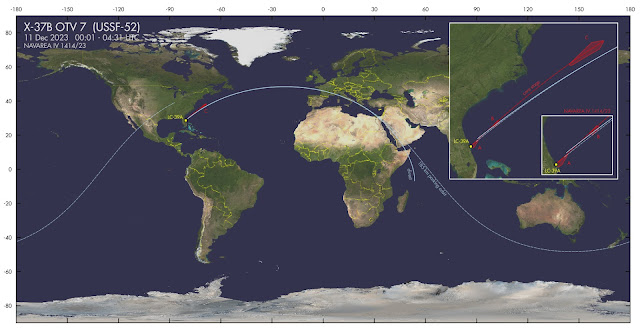
Navigational Warnings (NAVAREA IV 1414/23) have appeared which I believe are for USSF-52, the launch of X-37B mission OTV 7 (see also this earlier blogpost), on December 11.

This is the text of the Navigational Warning

061024Z DEC 23
NAVAREA IV 1414/23(GEN).
WESTERN NORTH ATLANTIC.
FLORIDA
1. HAZARDOUS OPERATIONS, ROCKET LAUNCHING
   110001Z TO 110431Z DEC, ALTERNATE
   0001Z TO 0431Z DAILY 12 THRU 17 DEC
   IN AREAS BOUND BY:
   A. 28-39.16N 080-37.80W, 29-12.00N 079-57.00W,
      29-10.00N 079-55.00W, 28-36.00N 080-15.00W,
      28-29.00N 080-24.00W, 28-27.60N 080-31.55W,
      28-27.94N 080-31.75W.
   B. 30-30.00N 078-35.00W, 30-58.00N 078-09.00W,
      30-52.00N 077-58.00W, 30-24.00N 078-23.00W.
   C. 36-07.00N 071-37.00W, 38-06.00N 069-34.00W,
      38-17.00N 068-32.00W, 38-13.00N 068-27.00W,
      37-32.00N 068-50.00W, 35-58.00N 071-28.00W.
2. CANCEL THIS MSG 170531Z DEC 23.//


It defines three areas: the immediate launch zone and side booster return corridor (A); the fairings splashdown zone (B); and the core stage return zone (C).

The initial launch azimuth results in an orbital inclination of about 48.25 degrees. I am however inclined to think that a dogleg might be involved at some point, and the real target inclination might be ~64 degrees.

From various leads it was speculated that USSF-52/OTV 7 might go into a high orbit, unlike previous OTV missions which al went to the lower reaches of Low Earth Orbit. Among the reasons for this speculation are the choice for a Falcon Heavy rather than Falcon 9, a mention of "new orbital regimes" in a recent US Space Force news bulletin on USSF-52, and a mention of a GTO orbit in a 2017 procurement document for the launch (see this earlier blogpost).

The core booster return zone is at some 1500 km from the launch site, which is a distance similar to what we have seen with launches into GTO, such as USSF-44. The launch azimuth however clearly does not match a GTO orbit.

But it all does point to a high apogee orbit. This indicates that perhaps a ~64 degree inclined HEO is targetted. No Navigational Warnings have yet appeared for the second stage (but they might appear later, closer to launch [edit 8 December: as they did! see update below]), which could indicate it will stay on orbit, which also points to a high apogee.

All kinds of speculations are possible, up to the possibility of a service/inspection mission to one of the NRO assets in HEO. Looking at the launch window and orbital plane positions, potential targets then could be USA 179 and USA 184. [update: as the apogee looks to be over the southern hemisphere, this does no longer look very likely though)

It will be interesting to see in what orbit it eventually goes, although with all, uncertainty it might be difficult to locate once on-orbit.

The map in top of this post depicts two scenarios: one for direct orbit insertion into ~48 degrees inclined HEO, and one for a ~185 km coasting orbit.  

EDIT: the map below provides a newly developed scenario aiming for HEO.


UPDATE 8 December 2023:

Indeed, a second Navigational Warning, NAVAREA XII 846/23, has now appeared, that seems to define the second stage deorbit zone. It confirms that after launch, at some point a dog-leg is done with the 2nd stage pushing the payload into a higher inclination orbit - the shape and direction of the area suggests a 74-degree inclined orbit.

071019Z DEC 23
NAVAREA XII 846/23(16,17,19).
EASTERN NORTH PACIFIC.
1. HAZARDOUS OPERATIONS, SPACE DEBRIS
   110001Z TO 111615Z DEC, ALTERNATE
   0001Z TO 1615Z DAILY 12 THRU 17 DEC
   IN AREA BOUND BY
   51-04N 152-41W, 53-27N 141-07W,
   41-40N 136-32W, 38-43N 146-53W  
2. CANCEL THIS MSG 171715Z DEC 23.//


I am not entirely certain about the scenario which follows next: but one scenario that fits is initial launch into a 48-degree inclined low orbit, a brief coast, and then 20-25 minutes after launch, over the NE Atlantic, a burn that doglegs the payload into a 74-degree inclined Highly Elliptical Orbit with apogee near 35188 km. This would have the second stage return to perigee (where it can be deorbitted) over the area defined by NAVAREA XII 846/23 at the end of the first revolution. See map below.

(the trajectory in the map below is so weirdly curved, rather than the usual sinusoid, because it is a ground-projection of the 2.3 rev/day HEO trajectory).

click map to enlarge

The resulting HEO is somewhat unusual: 74 degrees inclined (rather than the typical 64-degree Molniya orbit) and with apogee over the southern hemisphere. I am not sure my reconstruction is correct and am open to other suggestions.

USSF-52 OTV 7                for launch on 11 December 2023 01:18 UTC
1 70000U 23999A   23345.07222222  .00000000  00000-0  00000-0 0    08
2 70000 074.0000 314.2121 7272705 135.6501 359.9903 02.32559366    04

Launch time will reportedly be 01:18 UTC (December 11)


SECOND UPDATE, 11 Dec 19:00 UTC:

The launch has slipped one day, to 12 December 1:14 UTC. And I have revised my orbit estimates, based on new Navigational Warnings (specifically NAVAREA XII 854/23), that put new time constraints that might indicate that the apogee altitude that is higher than my initial estimate:

USSF-52 OTV 7                  for launch on 12 Dec 2023 01:14:00 UTC
1 70000U 23999A   23346.07013889  .00000000  00000-0  00000-0 0    06
2 70000 074.0000 325.5453 7407989 135.5462 360.0000 02.15472011    09

This orbit has the second stage arrive over what I interpret as the second stage deorbit area around the opening time of  Navigational Warning NAVAREA XII 854/23 (corrected for the shift in launch time between December 11 and 12):

081805Z DEC 23
NAVAREA XII 854/23(16,17,19).
EASTERN NORTH PACIFIC.
1. HAZARDOUS OPERATIONS, SPACE DEBRIS 
   111253Z TO 111354Z DEC, ALTERNATE 
   1252Z TO 1354Z DAILY 12 THRU 17 DEC 
   IN AREA BOUND BY
   51-34.00N 141-57.00W, 49-51.00N 150-42.00W,
   40-55.00N 146-02.00W, 42-38.00N 138-36.00W.
2. CANCEL NAVAREA XII 846/23.
3. CANCEL THIS MSG 171454Z DEC 23.

The resulting orbit with apogee near 37700 km has a daily precession of 4m 22s, matching the 4-minute shift in launch time between december 11 and 12.

This is the resulting trajectory (see also earlier discussion above):

click map to enlarge


Below is the approximate initial coasting orbit, before the dogleg to HEO: I slightly revised it to an orbital inclination of 51.5 degrees so that it lines up better with the core stage return area C (my initial estimate was based on Area A only):


USSF-52 initial parking orbit  for launch on 12 Dec 2023 01:14:00 UTC
1 70001U 23999A   23346.05138889  .00000000  00000-0  00000-0 0    03
2 70001 051.5000 354.4138 0011414 048.2332 322.9851 16.30015116    06

Note that this all strongly hinges on whether the area defined by NAVAREA XII 854/23, south of Alaska, is indeed related to USSF-52 and not something else...


THIRD UPDATE 12 Dec 18:30 UTC

The launch was again postponed and is now slated for no earlier than 14 December 1:13 UTC.

Here are revised elset estimates:

USSF-52 OTV 7                  for launch on 14 Dec 2023 01:13:00 UTC
1 70000U 23999A   23348.06875000  .00000000  00000-0  00000-0 0    08
2 70000 074.0000 315.9156 7272705 135.6501 359.9903 02.32559366    00

USSF-52 coasting orbit         for launch on 14 Dec 2023 01:13:00 UTC
1 70001U 23999A   23347.05069445  .00000000  00000-0  00000-0 0    05
2 70001 051.5000 355.1488 0011414 048.2332 322.9851 16.30015116    02


click to enlarge

Thursday, 9 November 2023

Boldly going where no spaceplane has gone before? New X-37B mission OTV 7 to launch in December

X-37B OTV 6 after landing in November 2022 (image: US Air Force)


The US Air Force Rapid Capabilities Office has announced that the 7th mission (OTV 7) of its robotic X-37B Spaceplane will launch, as USSF-52, on 7 December 2023.

The launch will be done from Kennedy Space Center in Florida by SpaceX, using a Falcon Heavy. That is interesting, as it is a surprisingly heavy rocket for this launch: SpaceX has launched an X-37B mission before (OTV 5 in 2017) but using a more modest 'normal' Falcon 9 at that time. So why a Falcon Heavy this time?


X-37B OTV 5 pass photographed by the author on 21 April 2018. Click image to enlarge

In the Air Force announcement, it is stated that the upcoming OTV 7 mission will be "operating the reusable spaceplane in new orbital regimes". That is an interesting phrase in combination with the unusually heavy launch vehicle chosen.

It might imply that this mission will go to a much higher orbit. Indeed, this article in Ars Technica mentions a 5-year-old procurement document which mentions a 27-degree inclined,  35188 x185 km  GTO reference orbit, perhaps implying a mission to GEO (!) or maybe into a Highly Elliptical Orbit (HEO). That would certainly be 'boldly going where no spaceplane has gone before'! If they would launch to GEO and then bring it back, that certainly would be no mean feat.

This will be an interesting mission to track. We will know more when, early December probably, the Navigational Warnings for the launch appear, as these might provide some clues as to the orbit launched into.

Note added 3 December 2023:

The Air Force announcement mentions that the OTV 7 mission includes "experimenting with space domain awareness technologies". I wonder whether, if it is going to geosynchronous orbit, it will test the Silent Barker satellites (launched last September) by functioning as a mock-target.

Saturday, 6 August 2022

Observing China's Re-usable Test Vehicle (or "space plane")


frame stack. Click to enlarge

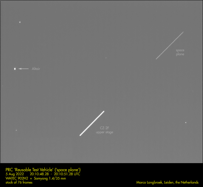
On August 4 2022 near 16:00 UTC, China launched a CZ-2F from Jiuquan carrying a "re-usable experimental spacecraft". It is the second orbital test flight of the Chinese 'space plane', China's answer to the X-37B, following an earlier orbital flight in September 2020 (see my 2020 blog post) . In 2020, the craft returned and landed on a landing strip near Lop Nur after two days on orbit.

Above is a frame stack of 76 frames showing the spacecraft and the CZ-2F upper stage from the launch in the evening of 5 August 2022 near 20:10 UTC. The frames are from the video below which I shot from Leiden, the Netherlands, with a WATEC 902H2 Supreme + Samyang 1.4/35 mm lens, in deep twilight (sun at only -6 degrees elevation):


The re-usable experimental spacecraft was launched into a 346 x 593 km, 50-degree inclined orbit. The orbital inclination is similar to the September 2020 test launch: the orbital altitude is however different this time. The 2020 test flight was in a 331 x 347 km orbit: the current flight is in a more eccentric orbit with higher apogee altitude (at almost 600 km, or 250 km higher than in 2020).


click image to enlarge


Eight objects (2022-093A to H) have been catalogued from this launch: the reusable test vehicle itself, the CZ-2F upper stage, four pieces of CZ-2F debris, and two additional objects of unknown character, objects G and H. The latter might be secondary payloads. They could perhaps be test targets to retrieve, or 'inspector' satellites to check the outside of the spacecraft. We'll see what happens. They are apparently small as my camera yesterday only registered the test vehicle and the CZ-2F upper stage.

On the previous flight, multiple objects were catalogued as well: apart from the test vehicle itself and the CZ-2F upper stage, there were - just like now- four pieces of CZ-2F debris catalogued. In addition an object was ejected from the test vehicle some 3.5 hours before the latter landed (speculation at the time was that it might have been an inspector satellite to inspect the outside condition of the spaceplane before the landing). That object reentered in December last year.

For the current test flight, the currently catalogued 8 objects, 2022-093A to 2022-093H, have varying apogee altitudes. The H-object has a notably more circular orbit than the other objects:

click diagram to enlarge

It will be interesting to see how long the orbiter will stay on orbit this time, and whether it will manoeuvre (it did not during the previous test flight). When it lands, we expect that to be at the same landing site as in 2020, a remote landing strip near Lop Nor (see the end of this 2020 post).


[added 7 Aug 2022]
 

Below is footage of another pass, taken in the evening of 6 August 2022. First object to come into view is the CZ-2F upper stage from the launch; then follows the 'space plane' (plus an airliner).


Saturday, 5 September 2020

China launches a 'Reusable Experimental Spacecraft' - a Space Plane? [UPDATED MULTIPLE TIMES]


Early September 2020, the space tracking community was in nervous anticipation of a rather mysterious Chinese launch. Amidst tight security measures, a Changzeng-2F (CZ-2F) rocket was readied at SLS-1 of Jiuquan's Launch Area 4. Chinese tracking ships were taking up positions near South America and in the Arabian Sea. Two NOTAM's appeared suggesting a launch between 5:20 and 6:00 UT on September 4. Something was afoot! Speculation was, that this was the long anticipated inaugural launch of a robottic Space Plane, a version of the Shenlong, China's answer to the American Air Force's X-37B robottic Space Plane.

Then, on September 4th, the Chinese news agency Xinhua published a very brief news item announcing that a CZ-2F from Jiuquan had launched a 'Reusable Experimental Spacecraft' earlier that day. 

The bulletin was scarce in information but stated that "after a period of in-orbit operation, the spacecraft will return to the scheduled landing site in China. It will test reusable technologies during its flight, providing technological support for the peaceful use of space".

No further details were given on launch time, orbit or character of the spacecraft. The description of the spacecraft is a bit ambiguous. Instead of a space plane, a 'reusable spacecraft' could in theory also be some sort of capsule (e.g. like the SpaceX Dragon): but most analysts think this indeed refers to the long rumoured space plane, China's answer to the US X-37B.

Pre-launch, and based on the positions of the hazard zones from the two NOTAM's, I calculated a launch into an orbital inclination of ~45 degrees, incidentally similar to the orbital inclination of the X-37B OTV 6 mission currently on-orbit. What's more, the launch window given (the NOTAM windows were from 5:23 to 6:05 UT) indicated the possibility of a launch into the orbital plane of OTV 6! The orbital plane of OTV 6 passed over Jiuquan at 6:00 UT - near the end of the launch window.

I published the following expected track for a launch into a 45 degree inclined orbit (which we now know is wrong):

Initial pre-launch trajectory guess. Click map to enlarge


When later that day the first orbital elements by the US military tracking network appeared on the CSpOC portal, it turned out that the orbital inclination was not ~45 degrees, but 50.2 degrees, 5 degrees higher than I anticipated. The reason for the mismatch, is that the rocket apparently did a dog-leg manoeuvre during ascend. This is very clear when we plot the orbital ground track in relation to the launch site and hazard zones from the two NOTAM's: it passes obliquely between them rather than lining up.

Actual orbital track. Click map to enlarge

 A 'dog-leg' manoeuvre is usually done for safety reasons, to avoid overflying a particular area downrange (e.g. a city or a foreign nation), but can also be done to insert the spacecraft into an orbital inclination that otherwise cannot be reached from the launch site. The latter is however not the case here - [editted] the orbital inclination is higher than the launch site latitude (you cannot reach an orbital inclination that is lower than your launch site latitude without a dog-leg, but higher you can.). So the reason must be range safety.

It is clear that the launch occurred well outside the NOTAM time window (why, is not clear). My analysis, based on a proximity analysis using the orbits of the spacecraft, the upper stage of the CZ-2F rocket, and that of four engine covers ejected upon spacecraft separation, indicate spacecraft separation and insertion into orbit around 7:41 UT on September 4th, over the Chinese coast with the orbital plane lining up with Jiuquan (see image below which depicts the orbital position at orbit insertion). The launch itself then should have occured some 8-10 minutes earlier i.e. around 7:30 UT, give or take a few minutes.

Moment of orbital insertion. click to enlarge
 

The spacecraft was inserted into a 50.2 degree inclined, initially 332 x 348 km orbit. During the hours after launch, the spacecraft made small orbital manoeuvres (see diagram below). At the time of writing (5 September 20:45 UT) it is in a 331 x 347 km orbit.

click diagram to enlarge

The later than initially expected launch time and, through a dog-leg manoeuvre, insertion into a 50.2 degree inclined orbit moved the orbital plane away from that of the X-37B OTV 6, although the two orbital planes are still near. Igor Lissov has pointed out some resemblance to the orbital plane of another US classified payload, USA 276, which has a similar orbital inclination to the Chinese spacecraft (but 50 km higher orbital altitude). The RAAN difference is 8 degrees:

click to enlarge

Based on the current orbits of all three spacecraft, there will be no close approaches of the Chinese spacecraft to either of these classified US payloads over the coming two weeks.

OTV 6 is currently in a 383 x 391, 45.0 degree inclined orbit. The difference in RAAN with respect to the Chinese spacecraft is 13.4 degrees, with a 5.2 degree difference in inclination and about 40-50 km difference in orbital altitude.

USA 276, the mysterious spacecraft that made a close approach to the ISS in May 2017 (see my July 2017 article in The Space Review), is currently in a 397 x 395, 50.0 degree inclined orbit. The difference in RAAN with respect to the Chinese spacecraft is 7.9 degrees, with a 0.2 degree difference in inclination and about 50-60 km difference in orbital altitude.

The Chinese 'reusable' spacecraft was launched from SLS-1, one of two launch platforms at Launch Area 4 of the Jiuquan Space Launch Center. Below is a Copernicus Sentinel 2B image of the launch complex, taken on September 2nd, two days before the launch. The two launch platforms are indicated: the southernmost one is the platform used for this launch.

click image to enlarge


It will be interesting to see where the 'reusable spacecraft' will eventually land. One likely candidate is a military airfield, the Dingxin Test and Training Base, that is located some 75 km southwest of the launch site. I have indicated both the launch site (A) and the potential landing site (B) in the Copernicus Sentinel 2B image below. The second image gives a more detailed look on the airbase.

Click image to enlarge

 
Click image to enlarge

We have no clue how long the spacecraft will stay in orbit. It will be interesting to see when and where it lands.

The 'reusable spacecraft' has the CSpOC catalogue entry #46389 (COSPAR ID 2020-063A). The CZ-2F upper stage is object #46390 (2020-063B). The four ejected engine covers (with apogees in the 458 to 566 km range), have numbers 46391-46394 (2020-063A to 202-063F).


UPDATE 6 Sept 2020 8:45 UT:

Xinhua reports on Sept 6 that the spacecraft has landed after 2 days on-orbit. Depending on the landing site, landing should have been (based on orbital overpass) either around 1:55 UT at Lop Nor (an alternative landing site suggested), or 6:45 UT at Dingxin Airbase.

UPDATE 2, 9:30 UT:
As the Chinese version of the Xinhua bulletin dates to an hour after the first option (1:55 UT), it seems that the landing was near 1:55 UT near Lop Nur in the Taklamakan desert (HT to Jonathan McDowell).

UPDATE 3, 10:30 UT:
This is the potential landing site, a triangular arrangement of 5 km long landing strips in the Taklamakan Desert. The orbital track of the spacecraft passed some 42.5 km northwest of it around 1:54 UT, more or less parallel to what appears to be the main landing strip:

Click image to enlarge

Click image to enlarge

UPDATE  4, 14:00 UT:
This is an updated diagram of the orbital evolution over the test flight. It seems no large manoeuvers were tried during this flight.


Click diagram to enlarge

UPDATE 5, 16:00 UT:

Jonathan McDowell noted that a new object related to the launch has been catalogued, object 2020-063G, #46395. My analysis suggests it was ejected from the experimental spacecraft near 22:25 UT on the 5th, two revolutions before landing. It likely is a cubesat of some sort. It is in a  332 x 348 km, 50.2 degree inclined orbit. (Update 8 Sept: on Twitter, Bob Christy has suggested that it might be a small inspector satellite, used to inspect the outside of the experimental spacecraft prior to deorbit)

Wednesday, 13 May 2020

[UPDATED] OTV 6 (USSF 7), the next X-37B launch, appears to go into a 44-degree inclined orbit

OTV 6.  Image: US Air Force. Click to enlarge

If weather cooperates, the next X-37B launch, mission OTV 6 ,also known as launch USSF 7, is slated for May 16, with backup dates on May 17 and 18 in case launch is postponed. The small uncrewed space plane will be launched for the US Air Force by the United Launch Alliance, with an Atlas 5 rocket, from Cape Canaveral SLC-41.

Navigational Warnings have now appeared for this launch, which shed light on the launch window and the orbit aimed for:

NAVAREA IV 388/20(GEN).
WESTERN NORTH ATLANTIC.
FLORIDA.
1. HAZARDOUS OPERATIONS, ROCKET LAUNCHING
   161224Z TO 161453Z MAY, ALTERNATE
   171314Z TO 171532Z AND 181354Z TO 181434Z MAY
   IN AREAS BOUND BY:
   A. 28-36-51N 080-35-57W, 28-41-00N 080-26-00W,
      28-36-00N 080-23-00W, 28-31-36N 080-33-34W.
   B. 32-28-00N 075-12-00W, 33-50-00N 072-51-00W,
      33-08-00N 072-17-00W, 31-45-00N 074-41-00W.
   C. 38-43-00N 062-38-00W, 40-23-00N 058-26-00W,
      39-18-00N 057-47-00W, 37-34-00N 061-56-00W.
2. CANCEL THIS MSG 181534Z MAY 20.//


HYDROPAC 1415/20(74,75).
SOUTHEASTERN INDIAN OCEAN.
DNC 03, DNC 04.
1. HAZARDOUS OPERATIONS, SPACE DEBRIS
   161319Z TO 161528Z MAY, ALTERNATE
   171409Z TO 171607Z AND 181449Z TO 181509Z MAY
   IN AREA BOUND BY
   36-03S 096-54E, 33-40S 098-30E,
   37-32S 108-22E, 40-03S 107-00E.
2. CANCEL THIS MSG 181609Z MAY 20.//


The launch azimuth defined by the three launch hazard areas A, B and C in the Atlantic Ocean and the location of the Centaur upper stage deorbit zone in the Indian Ocean, point to a launch into a ~44-degree inclined orbit, give or take half a degree. The Centaur upper stage will be deorbitted about half a revolution (55 minutes) after launch.

The following map depicts the hazard areas and the trajectory of the first orbit, for a 44-degree inclined orbit and an orbital altitude of ~350 km. The latter orbit fits the locations of the hazard zones well, and the ~55 minutes time difference between the start of the launch windows and the start of the Centaur upper stage deorbit windows in the Navigational Warnings combined with the position of the deorbit zone, fits a ~350 km altitude orbit:

Click map to enlarge

Launch into a 44-degree inclined orbit unfortunately means I do not get to track it from the Netherlands, as my observing location is too high north in latitude to see it in such an orbit. Following the previous OTV 5 launch, that went into a 54.5 degree inclined orbit and could be well observed from the Netherlands, I had some hopes for OTV 6, but alas no, it is not to be apparently...

A 44-degree orbital inclination would be similar to mission OTV 3 from 2012-2014. These are the orbital inclinations of all past OTV missions:

Mission     inclination    operational period        flight duration
OTV 1       40.0o          22/04/2010 - 30/11/2010   224 days
OTV 2       42.8o          05/03/2011 - 16/06/2012   468 days
OTV 3       43.5o          25/10/2012 - 17/10/2014   675 days
OTV 4       38.0o          20/05/2015 - 07/05/2017   718 days
OTV 5       54.5o          07/09/2017 - 27/10/2019   780 days
OTV 6       44.0o ?        16/05/2020 - ?

With regard to the upcoming launch, the given launch windows for May 16 and the two backup dates are curious. These launch windows are not the same duration (May 16 is 2h 29m in duration; May 17 is 2h 18m in duration; and May 18 only 40 minutes in duration).  They shift oddly from date to date too. The start of the given windows shifts 50 minutes between May 16 and 17; and shifts 40 minutes between May 17 and 18. It moreover shift to a later time between consecutive dates: while a given targetted orbital plane would make the launch shift to an earlier time, not a later time

Perhaps this is done to obfuscate the launch time and RAAN aimed for (or maybe it is just simply Range availability at play). If we look at the common ground: all three launch windows have a potential 10-degree wide RAAN window between 331o.14 and 341o.17 in common, so perhaps that is what is aimed for. If that interpretation is correct, this would lead to the following potential 40-minute launch windows, shifting back by 4 minutes each day:

16 May     13:58 - 14:38 UT
17 May     13:54 - 14:34 UT
18 May     13:50 - 14:30 UT

But of course, it is always possible that they launch straight away at the 12:24 UT opening of the May 16 window...we will see!

[Edit 15 May 2020 23:20 UT: but see note at end of post!]

A lot has been written about the X-37B and its purpose, and there are a lot of persistent misconceptions regarding the fact that it is a "space plane" (see my blogpost "X-37B fact and fiction" from July 2019).

Far from being a nefarious device, the X-37B appears to be a testbed for experimental space technology. According to the US Space Force, one of the things that will be tested during the next OTV 6 mission is an experiment to transmit solar power by microwave. It will also contain two NASA experiments that study the effects of radiation on materials and seeds, and it will deploy at least one military cubesat, FalconSat 8 (the previous OTV mission, OTV 5, released three cubesats).

The US Space Force Press Release also indicates that, as a first, OTV 6 will be fitted with a "service module" to the aft of the vehicle, that will house experiments (previous OTV missions housed experiments in the cargo bay). It will be interesting to see what happens to this service module at the end of the mission.

Addendum 13 May 22:05 UT:
More on the microwave experiment in this article (HT to Brian Weeden). It seems it is not so much transmission by microwave, but the generation of microwaves from solar power, which is then send through a cable, if I get it correctly. Anyway: something with microwaves...

Addendum 15 May 23:20 UT:

Bob Christy wrote a very interesting analysis on his Zarya blog, in which he links similar odd jumps in past OTV launch windows to times of close KH-11 passes, the idea being that these KH-11 satellites image the OTV after launch to see whether everything is allright. If that is correct, then this leads to four possible launch times on May 16: 12:24, 13:15, 14:06 and 14:53 UT.
My estimated elsets for these four launch times can be found here.

Addendum 18 May 13:55 UT:

OTV 6 launched on 17 May 2020 at 14:13 UT. A pre-launch estimated elset can be found here;  a preliminary radio-observation based orbit here.

Based on the preliminary radio elset, OTV 6 appears to have been inserted into a 45-degree inclined orbit at ~390 km altitude. The ground track repeats every 3 days:

click to enlarge

Here is how the launch track based on the radio orbit (red dashed line) compares to my pre-launch estimated launch track based on the locations of the hazard areas from the Navigational Warnings (blue dashed line):

click map to enlarge