Showing posts with label MRBM. Show all posts

Friday, 8 December 2023

A Missile Defense Test in the NE Pacific on December 11-16 (FTG-12?)

click map to enlarge
 

Two Navigational Warnings have appeared, NAVAREA XII 841 and NAVAREA XII 845, that together point to a Missile Defense test with a MRBM/IRBM target missile fired from NW of Hawaii towards California, and intercept by a GBI fired from Vandenberg, California. 

The window runs from December 11  to December 16 (2023). Here are the Navigational Warnings:

 061011Z DEC 23
NAVAREA XII 841/23(19).
EASTERN NORTH PACIFIC.
NORTH PACIFIC.
1. HAZARDOUS OPERATIONS 1430Z TO 1730Z DAILY
   11 THRU 16 DEC IN AREAS BOUND BY:
A. 24-40.00N 164-32.00W, 24-52.00N 164-43.00W,
   24-38.00N 165-07.00W, 24-26.00N 164-57.00W.
B. 27-13.00N 158-33.00W, 27-34.00N 158-49.00W,
   27-07.00N 159-45.00W, 26-44.00N 159-30.00W.
2. CANCEL THIS MSG 161830Z DEC 23.//


070807Z DEC 23
NAVAREA XII 845/23(18,19).
EASTERN NORTH PACIFIC.
CALIFORNIA.
1. HAZARDOUS OPERATIONS 11 THRU 16 DEC:
   A. 1400Z TO 1805Z DAILY IN AREA BOUND BY
      35-01.00N 121-13.00W, 35-01.00N 120-29.00W,
      34-45.00N 120-29W.00, 34-44.00N 121-13.00W.
   B. 1400Z TO 1805Z DAILY IN AREA BOUND BY
      34-35.00N 123-56.00W, 35-07.00N 123-56.00W,
      35-08.00N 121-13.00W, 34-36.00N 121-13.00W.
   C. 1400Z TO 1753Z DAILY IN AREA BOUND BY
      34-28.00N 126-07.00W, 35-11.00N 126-09.00W,
      35-12.00N 125-20.00W, 34-29.00N 125-18.00W.
   D. 1400Z TO 1846Z DAILY IN AREA BOUND BY
      35-08.00N 137-34.00W, 35-48.00N 128-26.00W,
      33-43.00N 128-13.00W, 32-52.00N 136-37.00W.
   E. 1400Z TO 1900Z DAILY IN AREA BOUND BY
      32-59.00N 138-18.00W, 34-45.00N 138-38.00W,
      35-06.00N 135-41.00W, 33-19.00N 135-25.00W.
2. CANCEL THIS MSG 162000Z DEC 23.//


As pointed out by Twitter user @M51_4ever, this could be test FTG-12, planned for the 4th quarter of 2023. It is a Ground Based Interceptor (GBI) test (part of the Ground Based Midcourse Defense (GBMD) system) where only two of the three stages burn, allowing an intercept at closer range (see also here).

The target missile appears to be a MRBM/IRBM fired from (probably) an aircraft in the vicinity of the fantastically named  French Frigate Shoals. The French Frigate Shoals is a reef/atoll in the Northwestern Hawaii islands, about halfway between Hawai'i and Midway, which got its name from the fact that two Frigates from the ill-fated late 18th century French LapĂ©rouse expedition (which is a name that should be familiar to any Jules Verne fans) nearly were lost there.

My interpretation is that the intercept will be about 1000 km out of the California coast, over area D from NAVAREA XII 845 (Area E probably is where stage 2/3 and any remains of the kill vehicle will come down). The target missile will fly some 3300 km before being intercepted (or not: previous tests had an about 1 in 2 miss chance).

In the map in top of this post, blue is the target missile, red the interceptor.

Wednesday, 12 October 2022

The North Korean Medium Range Missile test of October 3rd

click to enlarge

On October 3rd (October 4th local time in Korea) at 22:22 UTC, North Korea launched an MRBM from Mupyong-ri. They fired it over Japan on a normal ballistic trajector, instead of on a highly lofted trajectory, causing consternation and air raid alarms to go off in northern Japan. 

Firing a missile over Japan had not happened since the two Hwasong-12 launches in August and September 2017 (see earlier blog posts here and here). 

Western military sources indicate a range of approximately 4600 km and an apogee at approximately 1000 km. This is at the upper theoretical  limit of the Hwasong-12 MRBM.

Photographs of the launch were released (along with images of several other launches of SRBM and SLBM from the past weeks) by the North Korean State Press Agency KCNA on October 10. The surprise aspect of the images was that it seems to show a missile that is somewhat different in outlook than the Hwasong-12 we know, i.e. something new.

October 3 MRBM launch (image KCNA)

October 3 MRBM in flight (image KCNA)


In the image below, I have put an image from the Hwasong-12 launch from earlier this year, January 29, launched from the same location (Mupyong-ri), next to the October 3 launch. Below it are the outlines of the two missiles as traced from the photographs.


There are subtle differences, as several people (a.o. Nathan Hunt, Ankit Panda and me) have noticed. The missile overall seems similar in length and diameter, but the nosecone with RV  looks different in shape, and the first/second stage might actually be slightly taller than that of a Hwasong-12. And while the Hwasong-12 we know has a flared base of the first stage, the new missile seems to have a beveled base. In-flight images suggest it has one single engine only, whereas the Hwasong-12 we know has four Vernier engines in addition to the main engine, as does the Hwasong-14.

So this looks to be a new missile (or a new version of the Hwasong-12 or Hwasong-14).

The trajectory it has flown is longer than that of the previous two Hwasong-12 launches over Japan in August and September 2017, as can be seen in the image below. This might also point to a new missile, or a clearly improved single-engine version of the Hwasong-12 or Hwasong-14.


click to enlarge


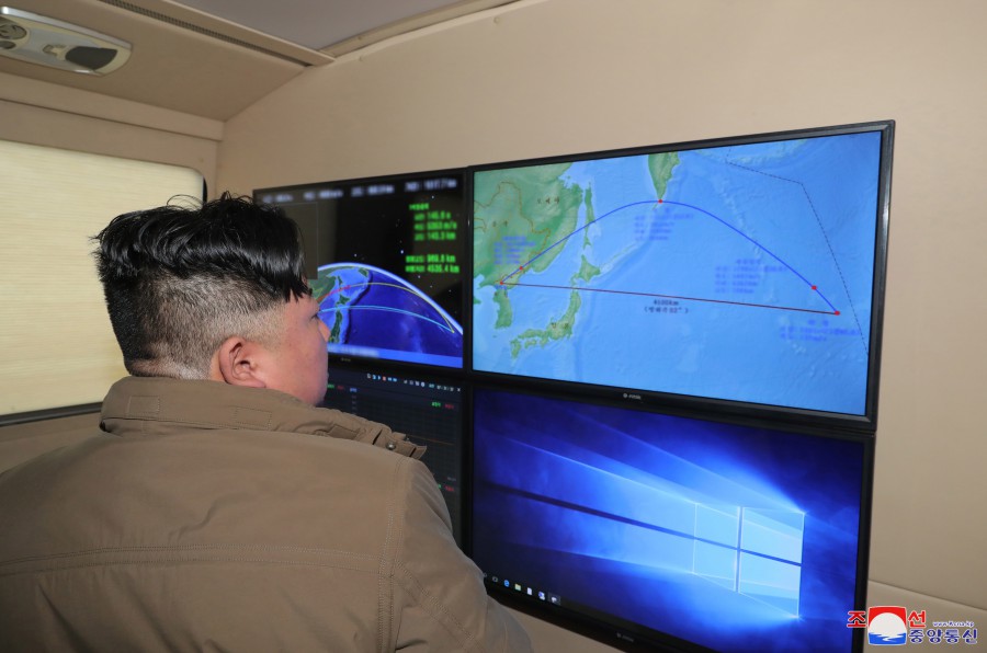
image KCNA


Among the images released by KCNA is one showing Kim Jung Un looking at a computer screen depicting a missile trajectory (see image above). I rectified the map shown on the screen and georeferenced it to an equal-area map (see below), yielding the trajectory below which matches well with a 4500 km trajectory (from the map I measure a range of ~4560 km, but given the error margins in processing this map, that basically is ~4600 km):

click to enlarge


The yellow dashed line (which was added by me as an overlay, as are the country outlines in black and yellow annotation) shows what a real ballistic trajectory would look like.

If the trajectory diagram is to scale hirozontally and vertically, then apogee should have been ~1300 km, slightly more than the ~1000 km quoted from western military sources.

The impact point of the missile is at 34.6 N, 178.3 E, close to the International Date Line. While passing over the Japanese islands, it was at an altitude of about 740-750 km, ascending towards its apogee.

From the launch images, the launch site is the same as that of the January 29 Hwasong-12 launch earlier this year: the Mupyong-ri facility (see earlier blog post here) at 40.6112 N, 126.4257 E. The treeline and pavement, and small side road, is very recognizable. The same location also saw the first successful Hwasong-14 launch on 28 July 2017 (the Hwasong-14 is a two-stage version of the Hwasong-12). If the October 3rd launch indeed is a new missile, as it looks to be, then this facility has now seen launches of three different MRBM's: Hwasong-12, Hwasong-14 and this new missile.