Thursday, 28 July 2022

CZ-5B rocket stage 2022-085B: reentry forecasts

 (this post is periodically updated when new tracking data become available and have been analyzed)

last updated 30 July 19:05 UT   

My latest forecast is: 30 July, 17:10 UTC +- 15m

The latest CSpOC forecast was:  30 July, 16:49 UTC +- 10m 

The FINAL CSpOC TIP is 16:51 UTC +- 1m, near 3.4 N, 113 E

A possible reentry observation has been made from Kuching (Sarawak, Borneo) near 16:50 UTC 

Click diagram to enlarge


On 24 July 2022, China launched a CZ-5B rocket carrying the Wentian module to the Chinese Space Station. The huge CZ-5B core stage, 2022-085B, with a dry mass of 18 tons and a length of 33 meter, is now set for an uncontrolled reentry on July 30.

The diagram above shows the evolution of apogee and perigee altitudes so far.

I am running reentry models in the General Mission Analysis Tool (GMAT) for the CZ-5B stage, that currently point to reentry in the second half of July 30 UTC. At this point in time it is still too early to pinpoint a more precise time or location - and for this reason I do not give geographic coordinates for the nominal reentry point yet.

The map below shows the current risk area, based on the latest forecast and its uncertainty window. Within the uncertainty window, the rocket stage can come down anywhere on the blue line in the map. The yellow circle is the nominal reentry position, i.e. the center of the uncertainty interval, but not necessarily the most likely location.


Current risk area. Click map to enlarge

Movement of the spacecraft is from west to east = left to right on the map. Cities between 41.5 N and 41.5 S with 1 million or more inhabitants are shown as yellow dots.

Below is a diagram of the evolution of the reentry forecast so far. Below the diagram is the same data in tabular form, with the most recent forecast at the bottom of the table.

- My latest GMAT based forecast (black dots) is: 30 July, 17:10 UTC +- 15 m

- The last pre-reentry CSpOC TIP forecast (red dots) is: 30 July, 16:49 UTC +- 10 m

- The FINAL CSpOC TIP is 16:51 UTC +- 1 m, near 3.4 N, 113 E

The latter time, with its 1 minute uncertainty, and position are likely based on an infra-red detection of the reentry fireball by a SBIRS Early warning satellite. So it seems my last forecast was about 20 minutes off. It reentered more or less at the start of my uncertainty window.

Below is a map with the final revolution and actual reentry location:


click map to enlarge


EXPLANATION OF THE DIAGRAM BELOW:
Each dot is a prediction based on a new orbit release. On the x-axis is the date/time (in decimal days) of the orbit on which the forecast is based. On the y-axis is the predicted reentry time/date resulting from a GMAT model run using  this orbit. These too are given in  decimal days (e.g., "30.5" = "30 July, 12:00 UTC". Note: for dates beyond July 31, "July 32.0" means "August 1, 00:00 UTC" etc.). 

Error bars show the uncertainty in the prediction. Note how the uncertainty window become smaller once we get closer to the reentry.

The black dots are the results of my GMAT model runs. The red dots are predictions by CSpOC, the US Military tracking organization (and "the" authoritive source of orbital tracking data), given for comparison.

click diagrams to enlarge

My reentry modelling in GMAT uses the MSISE90 model atmosphere, current, predicted and past spaceweather, a dry mass of 18000 kg and a drag surface of 62% of the maximum value, which is the best estimate for the average drag surface of a tumbling rocket stage of these dimensions. The depicted uncertainty window is a fixed 20% of the timespan between orbit epoch and the reentry time forecast resulting from the orbit.


GMAT model forecasts:

ORBIT DATE/TIME    REENTRY         UNCERTAINTY   REMARKS/Lat Lon
(UTC)              FORECAST (UTC)  INTERVAL

 25-07 11:52:33    31-07 08:28  +-  28.1 h
 25-07 13:01:55    31-07 02:51  +-  26.8 h
 25-07 14:30:57    31-07 02:42  +-  26.4 h
 25-07 17:29:00    31-07 02:45  +-  25.9 h
 25-07 19:29:01    31-07 02:08  +-  25.3 h
 26-07 03:04:47    31-07 02:39  +-  23.9 h
 26-07 11:16:28    31-07 03:40  +-  22.5 h
 26-07 13:11:03    31-07 02:22  +-  21.8 h
 26-07 15:43:05    31-07 02:34  +-  21.4 h
 26-07 18:40:46    31-07 02:44  +-  20.8 h
 26-07 19:12:28    31-07 01:04  +-  20.4 h
 27-07 14:41:30    30-07 21:29  +-  15.8 h
 27-07 15:55:00    30-07 20:57  +-  15.4 h
 27-07 17:18:31    30-07 21:01  +-  15.1 h 
 27-07 18:20:32    30-07 23:39  +-  15.5 h
 28-07 17:05:39    30-07 23:46  +-  10.9 h
 29-07 01:18:22    30-07 21:36  +-   8.9 h
 29-07 08:55:31    30-07 20:12  +-   7.1 h  
 29-07 13:03:52    30-07 19:20  +-   6.1 h   
 29-07 16:34:29    30-07 18:58  +-   5.3 h  
 29-07 18:00:07    30-07 19:00  +-   5.0 h  
 30-07 01:31:37    30-07 20:06  +-   3.7 h 
 30-07 08:22:22    30-07 17:50  +-   1.9 h  
 30-07 09:54:18    30-07 17:29  +-   1.5 h  
 30-07 12:28:44    30-07 17:28  +-   1.0 h 
 30-07 12:58:01    30-07 17:30  +-    54 m  
 30-07 14:17:27    30-07 17:20  +-    37 m   33 N 126 W  
 30-07 15:48:42    30-07 17:09  +-    16 m   40 N 178 E
 30-07 15:57:24    30-07 17:10  +-    15 m   41 N 173 W  latest


UPDATE 30 July 17:15 UT:

Footage purportedly shot today from Kuching (Sarawak, Borneo) appears to show the reentry of 2022-085B. It would place reentry near ~16:50 UTC. The footage is here, in a tweet by Nazri Suleiman.
I say 'purported' because for the moment the footage has not yet been verified. But it seems likely it is the reentry indeed.


UPDATE 30 July 19:05 UT:

CSpOC gives a final TIP of 16:51 +- 1m UTC near 3.4 N, 113 E, which matches the Kuching sightings well (multiple video's from the Kuching region have since turned up on social media, so it is now quite certain that this was the reentry).

The map below gives the final orbital revolution and location of reentry over Borneo.


click map to enlarge


Other forecast sources:

CSpOC  (https://www.space-track.org/)

Aerospace Corporation  (https://aerospace.org/reentries/cz-5b-rb-id-53240)

Josep Remis  (https://twitter.com/jremis)

ESA  (https://reentry.esoc.esa.int/reentry) 

EU-SST (https://twitter.com/EU_SST) 


Added note on 'Live' satellite tracking websites

BEWARE: contrary to what many people think, purported 'Live' satellite tracking websites such as n2yo.com are NOT showing you satellite locations based on 'live' tracking data!

In reality, they show predictions based on older orbital element sets, that can be hours old actually.

This can be deceptive. They sometimes happily show an object apparently still "on orbit" after it in reality already reentered!

Thursday, 7 July 2022

A failed US missile test on July 7


click to enlarge

In the first week of July, two Navigational Warnings appeared (NAVAREA XII 431/22 and HYDROPAC 1811/22) that indicated an ICBM-type missile test in the Pacific for a multiple day window starting July 7, with launch from Vandenberg AFB in California and target the Reagan Test Site at Kwajalein.

These are the Navigational Warnings in question:

030348Z JUL 22
NAVAREA XII 431/22(18,19).
EASTERN NORTH PACIFIC.
CALIFORNIA
1. HAZARDOUS OPERATIONS 0531Z TO 1234Z DAILY
   07 THRU 11 JUL IN AREAS BOUND BY:
   A. 34-47.00N 120-37.00W, 34-51.00N 120-36.00W,
      34-52.00N 121-25.00W, 34-39.00N 121-25.00W,
      34-40.00N 121-01.00W, 34-47.00N 120-37.00W.
   B. 34-56.00N 123-14.00W, 34-51.00N 123-57.00W,
      34-05.00N 123-49.00W, 34-10.00N 123-06.00W,
      34-56.00N 123-14.00W.
   C. 35-01.00N 124-11.00W, 34-48.00N 126-00.00W,
      33-40.00N 125-47.00W, 33-54.00N 123-59.00W,
      35-01.00N 124-11.00W.
   D. 34-34.00N 128-22.00W, 34-17.00N 130-07.00W,
      33-03.00N 129-49.00W, 33-20.00N 128-05.00W,
      34-34.00N 128-22.00W.
   E. 33-04.00N 136-33.00W, 32-51.00N 137-30.00W,
      31-54.00N 137-11.00W, 32-06.00N 136-15.00W,
      33-04.00N 136-33.00W.
2. CANCEL THIS MSG 111344Z JUL 22.


030450Z JUL 22
HYDROPAC 1811/22(81).
NORTH PACIFIC.
MARSHALL ISLANDS.
DNC 12.
1. HAZARDOUS OPERATIONS, 070600Z TO 071258Z JUL,
   ALTERNATE 080600Z TO 081258Z JUL
   IN AREAS BOUND BY:
   A. 09-16.00N 167-22.00E, 09-23.00N 167-33.00E,
      09-32.00N 167-26.00E, 09-37.00N 167-29.00E,
      09-37.00N 167-45.00E, 09-38.00N 168-00.00E,
      09-37.00N 168-03.00E, 09-07.00N 168-05.00E,
      09-05.00N 168-03.00E, 08-56.00N 167-34.00E.
   B. 08-56.00N 163-29.00E, 09-14.00N 165-41.00E,
      09-03.00N 166-19.00E, 08-18.00N 166-49.00E,
      07-25.00N 166-58.00E, 06-18.00N 166-54.00E,
      06-00.00N 165-11.00E, 06-15.00N 164-09.00E,
      07-30.00N 163-18.00E, 08-10.00N 163-12.00E.
2. CANCEL THIS MSG 081358Z JUL 22.


The number and geographic locations of the hazard areas indicated to me that this was not a standard Minuteman-III test. In the map below, blue are the hazard areas from the 7 July Area Warnings; red that for a typical Minuteman III test (shown example is the 29 Oct 2020 test). Near California, the number and positions of the hazard areas are clearly different.

click map to enlarge

As it turns out, this indeed was not a Minuteman-III launch, but a test launch of a Minotaur-II with a new experimental reentry vehicle, the Mk21A developed by Lockheed Martin. This warhead is a future  replacement for the W87 warhead on the future LGM-35 Sentinel missile being developed by Northop-Grumman.

The launch at 6:01 UT on July 7, was a failure: according to a press release from Vandenberg, the missile exploded about 11 seconds in flight, starting a fire in the area.

Rearrangements in the USA 328 - 331 'train'


click image to enlarge

In front of the 'train' USA 328 to USA 331 launched last month (see previous posts here and here), things are changing, and objects are being rearranged.  The train is streching out too. It now takes the train almost 6 minutes to pass, and the bright F object is no longer the last trailing object.

On the night of 5/6 July, USA 328 and USA 329 were very close to each other. The image above is a stack of 100 video frames (4 seconds)  showing both objects. The brightness difference of almost 2 magnitudes between (the objects we dubbed) USA 328 and USA 329 was remarkable.

Below is a video of this pass. The footage was made with a WATEC 902H2 Supreme + Samyang 1.4/85 mm lens.  The two objects were some 2 km apart in reality.


Wednesday, 22 June 2022

Observing newly launched USA 328, USA 329, USA 330, USA 331 and a Falcon 9 debris piece


The video footage above which I shot last night shows the classified objects covertly launched with the commercial Globalstar FM15 satellite on June 19 (see my previous post for backgrounds).

The objects are four payloads and a piece of Falcon 9 debris: USA 328 (2022-064B), USA 329 (2022-064C), USA 330 (2022-064D), and USA 331 (2022-064E), and they form a small 'train' with the piece of  Falcon 9 debris (2022-064F) trailing the four at a slightly larger distance. 


click image to enlarge (updated image)


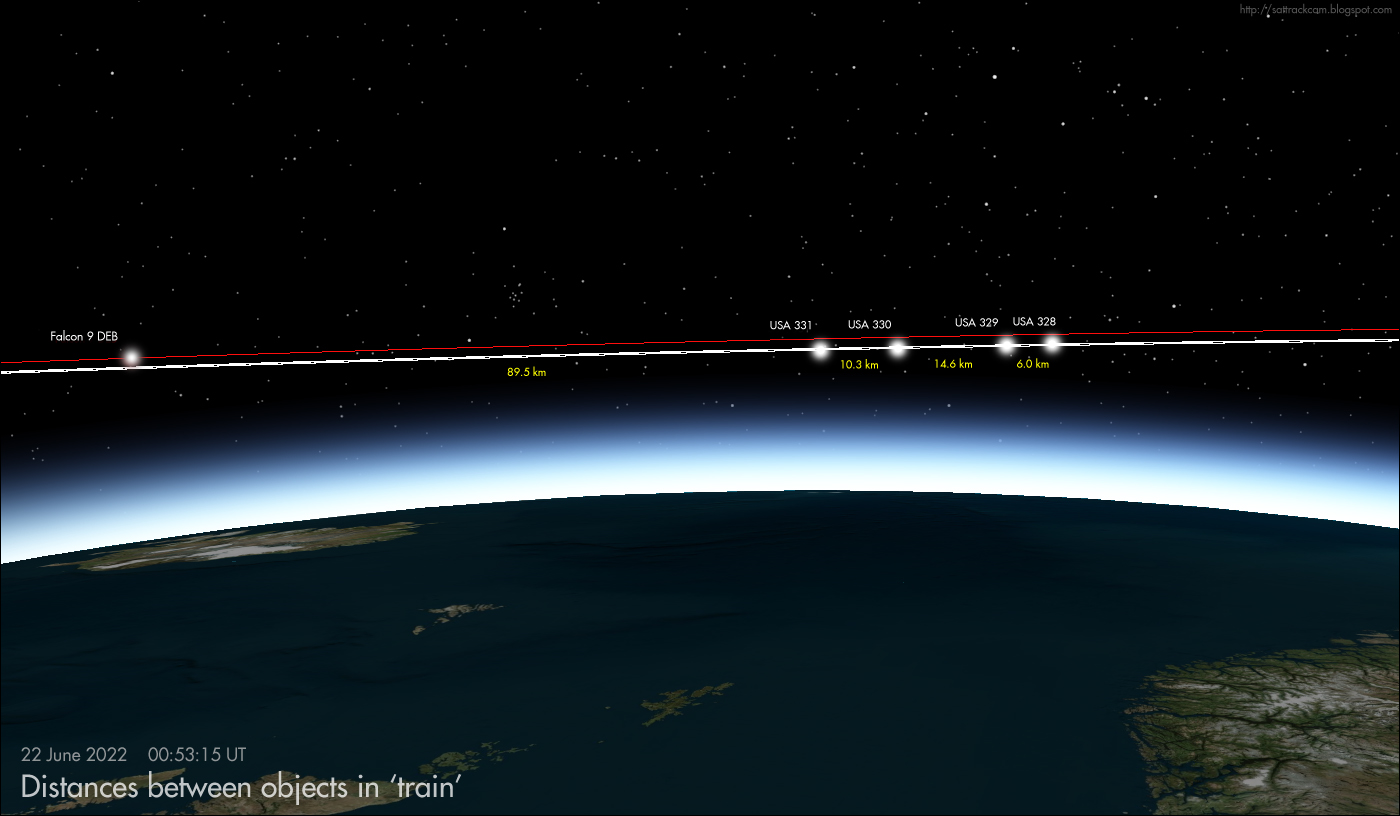
The image above [updated] shows the distances between the objects when they were over the Netherlands on June 22, 00:53 UT.

On June 20/21, 19 hours after launch, both Cees Bassa and me first picked them up, at more or less the same time, when we both did a planescan for the newly launched objects, using my estimated orbit here. They were a few minutes early on predictions, but pretty much on-track.

The payloads are faint, around magnitude +7 to +8: the Falcon 9 debris piece is much brighter, around magnitude +3.5 to +4.


Above is a frame-stack from video footage from that night. I used a Samyang 1.4/35 mm lens (I choose it because of its wide field of view), which with hindsight was not powerfull enough, so the four payloads were barely visible in the video: but the framestack nevertheless gives a good indication of the grouping of the objects (the Falcon 9 debris piece, F,  was still reasonably close that night - it is slowly getting away from the payload group).

The next night, June 21/22, I used a more powerful lens, a Samyang 1.4/85 mm. This time all objects registered well, as can be seen in the video in top of this post. 

Below are two frame-stacks from the second of  two passes imaged with video that night, showing the 'train' of four payloads:


The second payload in the train ("USA 329") shows a slow but notable brightness variation, which can be noted in the video in top of this post, and also in the framestacks: note how it is fainter than the other objects in the first stack, and brighter in the second stack. This could indicate that it is tumbling. The other objects appear steady so far.

As can be seen in the framestacks, the payload 'train' seems divided into two subgroups (or pairs).

The payloads are in 520 x 531 km, 53.0 degree inlined orbits. The piece of Falcon 9 debris is in a 513 x 538 km orbit (these values might still change somewhat when future observations are added: they are based on a one-day arc). 

The orbit is clearly lower than the ~1111 x 1125 km orbit of Globalstar FM15, and the orbital inclination differs by one degree from the latter orbit.

click image to enlarge


Provisional orbital elements for all five objects, based on observations by Cees Bassa and me from three imaged passes on two consecitive nights (June 20/21 and 21/22):


USA 328                                                  520 x 531 km
1 52889U 22064B   22173.02277179 0.00000885  00000-0  48598-4 0    08
2 52889  53.0076 219.0756 0008275 266.6022  93.4023 15.13589607    07

rms 0.013 deg      22 obs  Jun 20.98 - Jun 22.04 UT


USA 329                                                  519 x 531 km
1 52890U 22064C   22173.02278172 0.00000889  00000-0  48818-4 0    03
2 52890  53.0020 219.0447 0008904 282.2135  77.7858 15.13589477    09

rms 0.018 deg      18 obs  Jun 20.98 - Jun 22.04 UT


USA 330                                                  519 x 531 km
1 52891U 22064D   22173.02280361 0.00000956  00000-0  52537-4 0    05
2 52891  52.9994 219.0247 0008947 287.7569  72.2446 15.13572484    07

rms 0.012 deg      22 obs  Jun 20.98 - Jun 22.04 UT


USA 331                                                  520 x 531 km
1 52892U 22064E   22173.02281812 0.00000893  00000-0  49073-4 0    09
2 52892  53.0012 219.0348 0008303 279.7321  80.2731 15.13564015    03

rms 0.010 deg      22 obs  Jun 20.98 - Jun 22.04 UT


FALCON 9 DEB                                             513 x 538 km
1 52893U 22064F   22173.02296837 0.00000882  00000-0  48416-4 0    01
2 52893  52.9956 219.0143 0018707 315.9409  44.0091 15.13486695    05

rms 0.016 deg      27 obs  Jun 20.98 - Jun 22.04 UT

Monday, 20 June 2022

A covert launch on June 19? [UPDATED]


click map to enlarge


On 19 June 2022 at 4:27 UT, SpaceX launched a Falcon 9 from Cape Canaveral pad 40 ostensibly carrying a Globalstar block II communications satellite, Globalstar-2 FM15

However, something was odd about this launch, and rumour has it that it covertly launched a second unacknowledged payload for the US Government. [UPDATE: now confirmed. And it are actually 4 payloads!]

This payload, if it exists, was seemingly released into a lower orbit than the Globalstar payload eventually was, possibly (as suggested by Cosmic Penguin on Twitter) at ~535 km (the Globalstar satellite was subsequently released at a much higher  ~1125 km altitude). It likely is in the same 52-degree inclined orbital plane as the Globalstar satellite. 

At ~535 km and with ~52 degree orbital inclination, this means the covert payload is hiding near the forest of Starlink satellites, which orbit at around ~550 km in 53-degree inclined orbits, only slightly higher in orbital altitude and 1 degree higher in orbital inclination.

The oddities with the launch that gave rise to the rumour are listed in this Spaceflight.com article. Given the mass of a Globalstar satellite and capacity of a Falcon 9, there was no need to have the first stage land on a droneship downrange in the Atlantic Ocean, rather than have it return to land at Cape Canaveral. This suggests it might have carried a heavier payload (e.g., because a second covert payload was on board), which lead to the rumours.

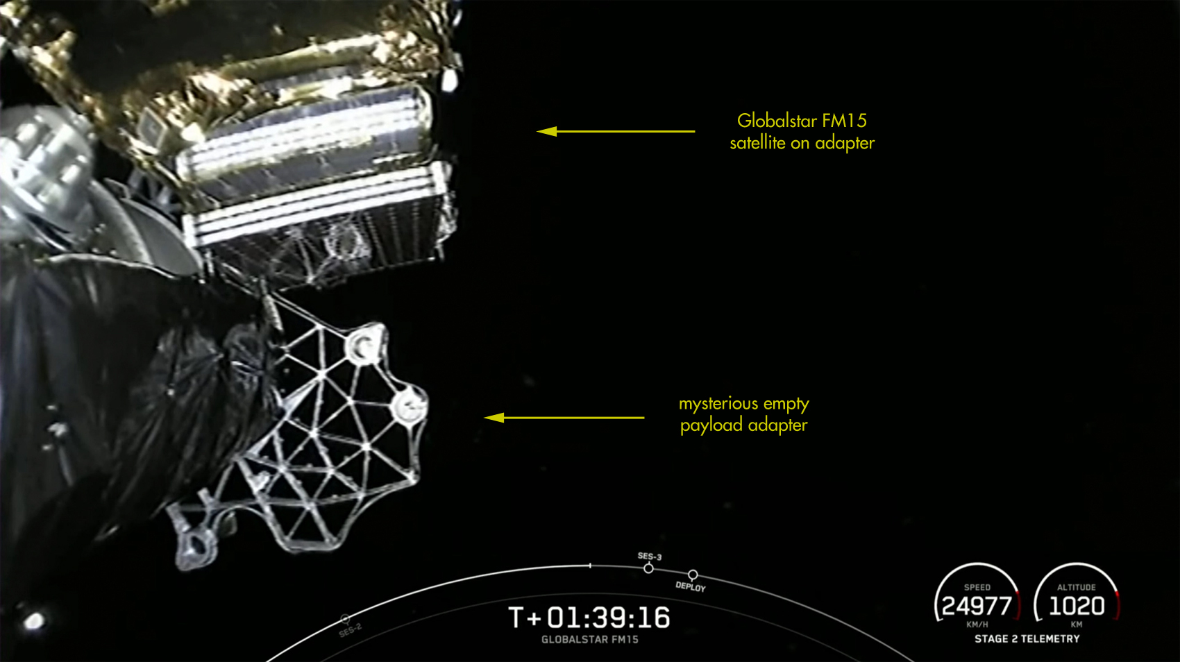
And then, just before the Globalstar deployment, live in-flight footage was shown (screenshot below) that showed something odd: the Globalstar satellite (still attached to the payload adapter on top of the rocket stage) and what looks like a second, empty payload adapter.


click image to enlarge

So this gives credence to the suspicion of a covert deployment of a second satellite in a lower orbit, before deployment of the Globalstar payload into a higher orbit.

The live webcast made no mention of such a second payload: after initial orbit insertion of the Falcon 9 some 10.5 minutes after launch, merely a long 'coasting phase' was suggested (with no live footage during this coasting period), before an orbit raising burn 1 hour 5 minutes after launch (~5:33 UT) , followed by a circulation burn 1 hour 47 minutes after launch (~6:14 UT) and deployment of the Globalstar satellite at 1h 53 minutes after launch (6:20 UT).

At the moment the live feed cut out after reaching orbit, the Falcon 9 seemed to be in a coasting orbit at ~535 km altitude. If there was a covert second payload, it was likely released at this altitude, either just after orbit insertion of the Falcon 9 upper stage slightly over 10 minutes after launch, or just before the orbit raising burn at about an hour after launch. The latter burn, at about ~5:33 UT, was to raise the Falcon 9 plus payload to the orbital altitude of the Globalstar satellite. It was followed some 40 minutes later by a brief orbit circularization burn, at ~6.14 UT.


click map to enlarge


The orbit circularization burn at ~6:14 UT and deorbit burn after 6:20 UT happened over the central and eastern United States and caused a spectacle in the sky, with a 'smoke ring' (probably from the circularization burn) followed by a bright fuzzy cloud (probably the start of the deorbit burn).

This footage of the sky events related to the circularization burn and deorbit burn was made by Dan Bush in Albany, Missouri:


More images can be seen on the Spaceweather.com site here. Some very nice images which can be seen here were taken by Lick Observatory telescope operator Keith Wandry.

Spectacular views were also seen an hour later over New Zealand, where the Falcon 9 upper stage tank depressurization (fuel vent) in anticipation of the deorbit over the Pacific Ocean near Hawaii caused the by now familiar, spectacular bright 'spiral' cloud in the sky typical for Falcon 9 upper stage fuel vents (e.g. see an earlier similar event here, connected to the ill-fated Zuma launch in 2018). Imagery of the spiral cloud can be seen here.

In terms of the potential orbit of the covert payload, if it exists: a lot is uncertain, but I offer this very rough search orbit: [EDIT: updated orbits based on observations here]

UNKNOWN    launched with Globalstar FM15
1 70001U 22999A   22170.18541667  .00000000  00000-0  00000-0 0    02
2 70001 052.0000 230.1696 0001447 047.8547 325.7015 15.10393460    00


UPDATE 1 (20 June 20:45 UT):


The CSpOC catalogue list 4 (four) additional objects for this launch (all with orbital elements witheld):
USA 328, USA 329, USA 330 and USA 331 (catalogue nrs 52889 to 52892).


UPDATE 2 (23 June 10:00 UT):

We are tracking the objects from the launch, see this follow up post. One of the four payloads seems to be tumbling.

Thursday, 16 June 2022

Some personal news: Lecturer in optical Space Situational Awareness

I have some personal news to report. 

As of June 1, I have been appointed as Lecturer in optical Space Situational Awareness at Delft Technical University (TU Delft), in the section Astrodynamics and Space Missions of their Faculty of Aerospace Engineering. It is, at my own request, a part-time appointment (0.5 fte).

This is what my new workplace looks like (my new office is in the towering building in the background):

click image to enlarge

Optical SSA will be a new addition to the MSc teaching curriculum at the Aerospace Engineering faculty. So we will have to start from the ground up. I will closely cooperate with a second newly hired person, who will start in August.

Apart from teaching, there is also room for research. Among the topics I personally want to pursue in my new position, are XGEO, and object characterization. I also plan to include some work on NEA's if possible, and it would be nice if I could bring some Space Archaeology into the teaching curriculum as well. We'll see.

I will leave my position as SSA consultant at Leiden Observatory (the astronomy dept. of Leiden University) on July 1, but will continue close cooperations with my Leiden colleagues.

Saturday, 21 May 2022

Observing the Boeing CST-100 Starliner OFT-2 and the ISS just hours before docking.


click image to enlarge

The image above shows the International Space Station ISS (the brightest trail) beying chased by the Boeing CST-100 Starliner OFT-2 (the fainter trail), in evening twilight of May 20, some 4 hours before docking of the two objects.

The image was taken with a Canon EOS 80D fitted with a Samyang 1.4/35 mm lens set at F2.0, and is a 1-second exposure at ISO 200, taken in deep evening twilight (sun at -8 degrees below the horizon). The Coma Berenices star cluster is visible at lower left. The very faint satellite just left of the image center is the European weather satellite METOP-C (2018-087A).

The Boeing CST-100 Starliner is the much plagued crew-rated vehicle that is the second US post-Shuttle spaceraft capable of transferring crew to and from the ISS.  

Orbital Flight Test 2 (OFT-2) was launched on 19 May 2022 from Cape Canaveral in Florida with an Atlas V rocket. It docked to the ISS on 21 May 2022 at 00:28 UT. It is the first successful flight test of the vehicle, following the drama of OFT-1 in December 2019 and several postponements of the OFT-2 flight following reviews into the cause of the failures in 2019. It was uncrewed during this test flight.

I observed two visible passes last night, one in deep evening twilight around 20:36 UT (22:36 CEST), some 4 hours before docking, and a second near 22:12 UT (00:12 CEST), some 2 hours before docking. The imagery with this blog post is from the first, twilight pass.

During the first pass the two objects were both visible with the naked eye (even in strong twilight): the ISS of course being very bright, and the Starliner as a fainter object of magnitude +2 to +1 just behind it. The two objects chasing each other made for a very fine sight!

Below is a video I shot with a Canon EOS 80D and Samyang 1.4/35 mm set at F2.0, during the 20:36 UT pass, showing the pair descending to the eastern horizon, with the Starliner just behind ISS (watch it full-screen, it is a HD video):


At about 00:12 in the video, another fast moving object, briefly flaring brightly, is visible in the lower right corner, above the chimney. This is a left-over piece of hardware (the "trunk", 2021-103B) from the Crew Dragon Endurance mission. It was making its last few revolutions around earth, reentering later that night at 3:48 UT over the NE Pacific.

Below is a 140-frame stack of the relevant part of the video. Note how the trail of the Crew Dragon debris (trunk) at right is clearly longer than that of ISS and Starliner, due to it being in a much lower orbit (~150 km, versus ~420 km for ISS and Starliner) and hence moving faster over the sky. It briefly flared brightly, as can be seen:

click image to enlarge

Below is another image of the Starliner - ISS duo, this time a 1/4th second exposure separating them a bit better:


click image to enlarge


During the second pass at 22:12 UT, the Starliner and ISS were even closer. They were no longer separable as distinct objects by the naked eye or in my camera imagery: but they were two distinct objects in 10 x 50 binoculars, very close together, the Starliner this time just in front of the ISS. Their real separation distance at that time was in the order of 100 meters. It was a spectacular view!

The Boeing CST-100 Starliner will undock from the ISS and return to earth for a parachute landing on May 25.

Wednesday, 18 May 2022

Kosmos 482: questions around a failed Venera lander from 1972 still orbiting Earth (but not for long)

I have just published a new article in The Space Review. It is freely accessible here.

It is titled "Kosmos 482: questions around a failed Venera lander from 1972 still orbiting Earth (but not for long)".

It is an in-depth look at the recent controversy surrounding 1972-023E, the Kosmos 482 Descent Craft, a piece of hardware from a 1972 Soviet era Venera mission to Venus that failed and got stuck in Earth Orbit.

In it, I think I can conclusively answer several questions around this object, including that it is the 'descent craft' in its protective spherical shell only, rather than a substantial larger piece of Venera hardware as thought by some.

The article includes evidence from my own observations (photometry); comparisons of actual orbital evolution with long-term orbital simulations with the General Mission Analysis Tool (GMAT) for various objects associated to this launch; as well as radar cross sections published by CSpOC and LeoLabs. I also provide a new reentry forecast for 1972-023E

Read the article here on the website of The Space Review

Wednesday, 20 April 2022

USA 327 / NROL-85


The video above which I shot yesterday evening (19 April 2022) shows USA 327, the NROL-85 payload, passing over my home in Leiden, slightly over two days after it was launched. The footage was shot with a WATEC 902H2 Supreme Low Light Level CCTV camera with a Canon FD 1.8/50 mm lens fitted.

NROL-85 (see two previous posts about this very recent classified launch here and here) has now been catalogued (with orbital elements witheld) by CSpOC as USA 327, catalogue nr 52259, COSPAR ID 2022-040A. Only one object was catalogued, there was no spoof second 'debris' object entered.

As already mentioned in a recent post, the fact that there is no second object is a big surprise. We expected NROL-85 to deliver two payloads, a pair of INTRUDER (also known as NOSS, which stands for Naval Ocean Surveillance System), SIGINT satellites used for geolocating shipping on the High Seas by means of time difference of arrival of their radar/radio emmisions.

Before 2001, NOSS systems existed of three co-orbiting satellites forming a thight triangular formation. From 2001 onwards (with the launch of NOSS 3-1, the first of the Block 3 NOSS-es) , this changed into two co-orbitting satellites.

(the video below, from 30 August 2018, shows a typical NOSS pair, in this case both briefly flaring due to a favourable sun-satellite-observer angle on some reflecting part of the satellites. While operational, NOSS pairs always move this close together. The NOSS pair in question is  NOSS 3-6, the same NOSS pair into which orbital plane the new USA 327 satellite was launched).


And now, we have only one, not two, satellite launched in a NOSS-like orbit. Analysts are scratching their heads over this.

Given the strong similarity in orbit, and the fact that it was launched into the orbital plane of an existing 10-year-old NOSS pair (see previous post), NOSS 3-6 (2012-048A & P), there is clearly some conceptual link of the new satellite to the NOSS program

But in what way exactly? There are a couple of options:

(1) This is a new generation of NOSS/INTRUDER, (i.e. NOSS block 4-1), that needs only one satellite;

(2) This is something else, something new, but related to NOSS/INTRUDER;

(3) This was meant to be NOSS 3-9, a regular NOSS pair, but something went wrong and the second satellite was not deployed;

(4) There is a second satellite but it is small (cubesat) and not yet detected;

(5) The second satellite still has to detach from the first


So let us briefly comment on these various options:

Option (1) apparently, is feasible, according to some. Apparently it is possible to do TDA using just one satellite

With regard to option (2), the most interesting one, one could think of for example an optical or radar counterpart to the existing NOSS 3-6 SIGINT pair: one that images the ships geolocated by NOSS 3-6. This makes sense (and it also makes sense that the new satellite orbits half an orbit apart from the NOSS pair).

While we cannot exclude option (3), I think it is not the most likely option. The same goes for option (5): with previous NOSS launches, two objects were detected right after launch. I have no opinion on option (4).

If we look at the current orbit of USA 327 and the orbit of the NOSS 3-6 pair, we note that: 

(a) they move in almost the same orbital plane; 

(b) they currently are almost exactly half an orbital revolution apart (see illustration below); 

(c) because of the latter difference in Mean Anomaly, their ground tracks are not the same but have some distance between them.


click map to enlarge

Observation (c) does not entirely make sense to me. Wouldn't you want your imaging satellite to follow the same ground track as the geolocating SIGINT satellites? On the other hand: true: the footprints are large enough to cover a large overlap in ocean space from both groundtracks. But still....

Another aspect of this that does not completely make sense to me is that, if USA 327 is a technology demonstrator for a new complementary IMINT mode to the NOSS SIGINT system, then why pick a 10-year-old, nearly retired pair of NOSS satellites to test it with? Why not pick a fresher pair, so you can happily experiment away for the time to come?

But maybe, those fresher pairs of NOSS satellites are deemed more suited for when, after this technology demonstration, the truely operational system is deployed. But then again, why bother with that, just replace the technology demonstrator with the operational version and deorbit the technology demonstrator.

Questions, so many questions, and my still post-COVID impaired brain cannot make much sense of it yet...

It will be interesting to see what USA 327 does (in terms of orbital manoeuvres etcetera) the coming months.

Meanwhile, Radio observer Scott Tilley in Canada has detected the first S-band radio signals from USA 327. He reports "huge fades in signal", which is odd. From Cees Bassa I understand that the frequency in question, 2277.5 MHz, is a know frequency used during the checkout-phase of NOSS 3-x pairs.

A surprisingly bright flare from a 6U Cubesat


​The 240 frames frame stack above, which is from the video below, shows the classified Japanese satellite IGS Optical 5 (2015-015A). But at 21:14:05.5 UT, somethings else moving nearly parallel to the satellite briefly flares up.

The flaring object in question, producing a flare of at least magnitude 0, is TYVAK 182A (also known as ELO Alpha), 2021-034D. This is a 6U cubesat. I am quite surprised to see such a bright flare from such a small object!

The video was taken from Leiden, the Netherlands, with a WATEC 902H2 Supreme fitted with a Samyang 1.4/35 mm lens.

Monday, 18 April 2022

NROL-85 observed, but is it an INTRUDER/NOSS or something else? [UPDATED]

click image to enlarge


Yesterday 17 April 2022 at 13:13 UT, SpaceX launched the classified NROL-85 mission for the NRO. Before the launch we widely expected this to be NOSS 3-9, a new pair of INTRUDER/NOSS satellites (see previous post), based on clues as to the orbit it was launched into. 

The orbital inclination and orbital altitude suggested by OSINT infornation on the mission were typical for NOSS/INTRUDER, and the time of launch indicated a launch into the orbital plane of the 10-year-old NOSS duo NOSS 3-6. That is a pattern we have seen before with NOSS missions: a replacement launched into the same orbital plane after 10 years of operational service.

So we expected to observe two objects after launch. 

But NROL-85 had a surprise in store: so far, we detected only one object, not the expected two!

This leads to the question: is NROL-85 a new INTRUDER/NOSS, or not?

NROL-85 was first picked up by me, from Leiden, the Netherlands, some 7 hours after launch, in late evening twilight of 17 April around 19:59 UT (21:59 CEST). It was some 2.5 minutes early on my pre-launch estimated search elset. I subsequently also observed it on a second pass two hours later.

On the first pass, I captured it photographically (see image in top of this post, showing it above the roof of my house along with two old unrelated rocket stages), using a Canon EOS 80D with a Samyang 1.4/35 mm wide angle lens (the exposure is a 2-second exposure at ISO 800). The video system I had set up captured it too, but only very briefly in a corner of the field of view. Only one object was seen, nothwithstanding that I did a photographic plane scan during quite some time.

The second pass was in the northern sky with a less favourable phase angle (so the object was much fainter than during the first pass). I captured it with the video system, and after following it for a minute or so, left the camera stationary to look for a possible second object. None was detected, either before or after the detected object.

Likewise, fellow observers from the Seesat-L list including David Brierley and Eelke Visser, detected only one object too. And Scott Tilley reports that he did not detect radio signals at the frequencies usually used by NOSS.

The absence of a second object could mean that NROL-85 is not a new INTRUDER/NOSS mission after all, but something else, although the orbit is very NOSS-like.

Alternatively, perhaps it is an improved version of INTRUDER that now needs only one satellite, rather than two.

NOSS missions once consisted of three satellites orbiting close together in a triangular formation. In 2001 this changed to two satellites. Maybe now they found a way to do it with one satellite?

The object we detected is in a 1021 x 1191 km, 63.5 degree inclined orbit (update: with a longer observational arc constraining the eccentricity of the orbit better, the new value is ~ 1008  x 1207 km). This orbit is close to the specifications given in a launch contract tender for NROL-85. Below is a preliminary initial elset based on a 5.5 hour observational arc:

NROL-85 (USA 327)
1 70002U 22999A   22108.04497945 0.00000000  00000-0  00000+0 0    07
2 70002  63.5043 123.5866 0114230 185.9890 173.9785 13.40421486    07

rms 0.024 deg

Elset update (20 April 2022): Below is the latest elset based on 114 observations by Cees Bassa, Eelke Visser, David Brearley, Andriy Makeyev and me over a two-day observational arc:

USA 327 (NROL-85)                                      1008 x 1207 km
1 52259U 22040A   22109.98456423 0.00000000  00000-0  00000+0 0    08
2 52259  63.4462 118.5572 0132890 178.9713 181.1610 13.40467640    01

rms 0.011 deg    arc Apr 17.83 UT - Apr 20.01 UT


click to enlarge


As a final note: the post-deorbit-burn fuel vent by the Falcon 9 upper stage used for the launch of NROL-85, which was deorbitted over the Pacific Ocean at the end of the first revolution (see map in previous post), was seen and filmed from Hawaii, showing the characteristic spiral shape:


(a follow-up post is here)

Tuesday, 12 April 2022

NROL-85: probably NOSS 3-9, a new pair of INTRUDER Naval SIGINT satellites


image: Wikipedia

 EDIT (15 & 16 Apr):  the launch of NROL-85 has been postponed by at least two days, 'due to technical difficulties'

EDIT (17 Apr): new launch date is 17 April 2022 13:13 UT

On 15 April 2022, at 13:41 UT (or later) according to a tweet by the NRO, SpaceX will launch NROL-85 for the National Reconnaissance Office (NRO). The launch will be from SLC-4E at Vandenberg SFB. [edit 16 Apr: launch was postponed to 17 April 13:13 UT]

NROL-85 is almost certainly a pair of NOSS satellites. NOSS stands for Naval Ocean Surveillance System; they are also known under the code name INTRUDER. If correct, the duo would become NOSS 3-9 (the 9th mission of block III). It will probably enter with the designation USA 327 in the CSpOC catalogue (with orbital elements witheld).

NOSS satellites are SIGINT satellites operated by the US Navy. They geolocate shipping on the high seas, by detecting their radio/radar emissions. They always operate in close pairs. The secondary object is usually listed (with orbital elements witheld) as "debris" in the CSpOC catalogue, but this is a ruse that fools nobody: it is a payload too that manoeuvres and keeps a careful constant close distance to the primary satellite.

Information from the launch contract tender for this launch reveals that the mission aims for a semi-major axis of  7500.5 km, an orbital eccentricity of 0.0131, an orbital inclination of 63.535 degrees and an argument of perigee of 190 degrees (i.e. perigee almost on the equator). The listed semi-major axis and eccentricity translate to a 1024 x 1221 km orbit

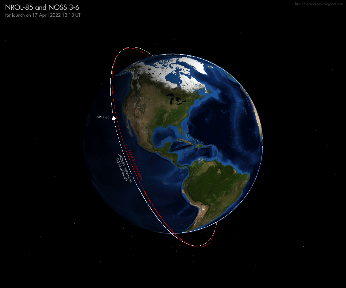
The combination of the 63.5 degree orbital inclination and 1024 x 1221 km orbit strongly points to a NOSS/INTRUDER mission. These typically have an orbital inclination of 63.4 degrees and a semi-major axis of 7485 km, values close to those quoted for NROL-85. If launch is indeed at 13:13 UT on April 17, the resulting orbital plane will be very similar to that of the existing NOSS 3-6 duo (2012-048A and 2012-048P) which was launched in 2012, as can be seen in the figure below. That also lines up with a new NOSS-launch: NOSS-pairs are typically replaced after 10 years on-orbit.

The shift in launch time with date due to the two launch postponements agree with the estimated orbital altitude and orbital plane and matches the nodal precession of a typical NOSS orbital plane.


click image to enlarge


The Navigational Warnings for this launch (NAVAREA IV 336/22 NAVAREA XII 228/22 and HYDROPAC 987/22) define a launch direction towards the south-southeast, and agree with the 63.5 degree orbital inclination of the launch contract tender. 


[EDIT: The first NavWarning has been corrected: I initially copied the wrong NavWarning for this post.....]

100706Z APR 22
NAVAREA XII 228/22(18,21).
EASTERN NORTH PACIFIC.
CALIFORNIA.
1. HAZARDOUS OPERATIONS 1150Z TO 1514Z DAILY
   15 AND 16 APR IN AREAS BOUND BY:
   A. 34-41N 120-38W, 34-39N 120-40W,
      34-28N 120-38W, 34-04N 120-17W,
      34-04N 120-05W, 34-19N 120-14W,
      34-39N 120-19W.
   B. 32-03N 118-53W, 32-01N 118-49W,
      30-51N 117-56W, 30-21N 117-39W,
      30-08N 117-47W, 30-11N 118-01W,
      30-32N 118-18W, 31-54N 118-53W.
2. CANCEL THIS MSG 161614Z APR 22.


100644Z APR 22
HYDROPAC 987/22(22,83).
EASTERN SOUTH PACIFIC.
DNC 06.
1. HAZARDOUS OPERATIONS, SPACE DEBRIS
   1425Z TO 1649Z DAILY 15 AND 16 APR
   IN AREA BOUND BY
   20-12S 123-30W, 19-00S 119-00W,
   33-48S 109-30W, 36-00S 114-12W.
2. CANCEL THIS MSG 161749Z APR 22.


I have mapped the hazard areas from the Navigational Warnings and the resulting launch trajectory in the map below (the times listed along the trajectory are in UT and for the updated launch date with launch at 13:13 UT (17 April):
 

click map to enlarge


Based on the parameters from the launch contract tender, this is my orbital estimate, valid for launch at 13:41 UT on April 15 updated for launch at 17 April 13:13 UT:


NROL-85                         for launch on 17 Apr 2022 13:13:00 UT
1 70002U 22999A   22107.55069445 0.00000000  00000-0  00000+0 0    02
2 70002  63.5350 124.8521 0131000 190.0000 291.3542 13.36458926    04


There is an uncertainty of several minutes in pass time in this elset, progressively so after more than one revolution, and some cross-track error is possible. But the elset should be good enough for a plane scan, taking a wide time window around a predicted pass. Be carefull not to misidentify the NOSS 3-6 duo as NROL-85. An elset for NOSS 3-6 can be found here.

If the eventual launch time turns out to be later than 13:13 UT, the elset above can easily be adjusted to match the new launch time using my "TLE from Proxy" software downloadable here.

The Northern hemisphere will see good, fully illuminated evening passes on the day of launch and the days after it, so prospects are good for a quick on-orbit detection after launch.

The Falcon 9 upper stage deorbit is over the southern Pacific, just after the end of the first revolution. The deorbit-burn might be visible from south and/or central Asia.

The launch patch (see top of this post) features a cat, with a tiger as its reflection. The NRO itself explains some of the symbolism in the patch in this way:

"In the NROL-85 patch, the 3 stars represent guidance, protection, and allegiance. The cat represents loyalty and devotion shared among our nation and partners. The tiger in the cat’s reflection demonstrates that while space can be challenging, a determined attitude helps NRO succeed in going"


Given that this is going to be NOSS 3-9, the 9th instance of the Block III NOSS generation, I wonder if the cat was inspired by the proverbial 'nine lives' of cats.

It is possible that a number of other small satellites will be included in this launch as a rideshare.

The NRO press kit for NROL-85 is downloadable here.

FOLLOW-UP POST HERE reporting the first observations of NROL-85 from the evening of April 17. NROL-85 might not be an INTRUDER/NOSS after all!

A SECOND FOLLOW-UP POST HERE, going a bit deeper into various speculations about what the NROL-85 payload might be.


[a small update to this post was made 13 April 2022 09:00 UT, adding a bit more background information]

[an error where I had initially copied the wrong text of a NavWarning into this post was corrected at 13 Apr 20:30 UT - many thanks to the anonymous sharp-eyed reader who noted it!] 

[updated April 15 & 16 to reflect launch postponements] 

[updated 17 Apr 8:45 UT with updated launch trajectory map and orbital plane diagram]

Friday, 25 March 2022

North Korea's Hwasong-17 ICBM: capable of (briefly) bringing warheads into orbit?

image: KCNA/RodongSinmun

According to multiple western sources and North Korea, North Korea conducted a first full-power test-flight of its new Hwasong-17 ICBM on March 24, 2022, at 5:34 UT, from Sunan close to Pyongyang.

The Hwasong-17 is the Behemoth missile that was first revealed to the outside world one-and-a-half-years-ago during the 2020 October 10 parade in Pyongyang and surprised everyone by its massive size at the time. It is North-Korea's largest, heaviest missile so far and visually looks like a Hwasong-15 on steroids.

[NOTE: some sources are now casting some doubt on the missile identity, suggesting that footage from the failed March 16 launch (see below) was used. See comment at end of post]

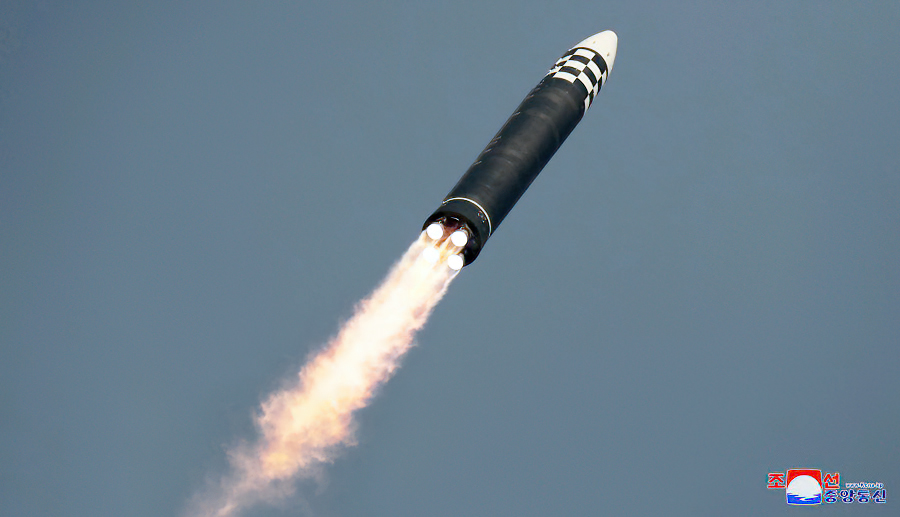
The test launch was confirmed by North Korean State sources which produced a written account on their KCNA and Rodong Sinmun websites, accompanied by photographs, while KCNA also broadcast a video of the test. The imagery underlines how impressive the size of the Hwasong-17 is: it is a Monster of a missile!


image KCNA/Rodong Sinmun

 
image KCNA/Rodong Sinmun


image KCNA/Rodong Sinmun

The video report on the test as broadcast by the North Korean State Agency KCNA is spectacular, with a glamour role for the sunglasses-clad North Korean leader Kim Jung Un (look at 3:55 to 4:05 in the video below!). It evokes shades of a Hollywood action movie trailer. 

(the actual footage of the test and test preparations starts at 3:25 in the video, after the usual bombastic introductions by news anchor Ri Chun-hee)


Earlier test flights of components of the same missile might have taken place in Februari and early March (but not on full power), according to western sources. North Korea claimed at the time that it was testing components for a reconnaisance satellite program. 

We also know that on March 16, another test flight from the same launch-site (near Sunan Airport), possibly also a Hwasong-17, failed shortly after launch at an altitude of less than 20 km.

But the March 24 test flight appears to have been successfull, as claimed by both North Korea and western sources. According to North Korean official State sources it reached an apogee at a whopping 6248.5 km altitude, with a ground range of 1090 km and a flight time of long duration (1h 7m 30s).

Western sources that independently tracked the launch mention similar ballpark values for this test: apogee "6200 km" and range "1080 km" according to the S-Korea Joint Chiefs of Staff; apogee "6000 km" and range "1100 km" according to the Japanese Government. The missile came down in front of the Japanese coast inside Japan's EEZ, at some 180 km from Cape Tappi. 

The apogee is at an extreme altitude, and this test was hence extremely lofted, as can be seen in this trajectory reconstruction I made:


click to enlarge

Looking into the necessary impulse in order to assess maximum range of the missile, I realized that the resulting nominal impulse of 7.85 km/s I reconstruct, actually means that the Hwasong-17 can achieve orbital speed. In other words: this means it is powerfull enough to, in principle, loft a payload to (low) earth orbit and get it (briefly) orbital!

Objects can complete at least one revolution around the earth if they have enough orbital velocity such that they can orbit at at least 100 km altitude (the exact value of the lower limit of orbital flight is debated: for circular orbits it might be possible at altitudes as low as 80-90 km, but it anyway strongly hinges on the drag characteristics of the object in question). The corresponding orbital speed at 100 km altitude is 7.84 km/s (for a circular orbit). The nominal impulse I get for the March 24 launch, at 7.85 km/s, matches that (in reality, it is more complex, as the missile will experience atmospheric drag during the initial phase of launch, which was not part of my reconstruction. And part of the initial impulse will be lost due to gravity pull before reaching 100 km altitude).

So in theory, this missile could briefly get an object (e.g. a warhead) in orbit around the earth, rather than on a suborbital ballistic trajectory. In case you wonder: it didn't on March 24, because it was not launched on an orbit insertion trajectory, but rather straight up.


image: KCNA/RodongSinmun

image: KCNA/Rodong Sinmun

image: KCNA/Rodong Sinmun


This was not something I had expected. But it gives a new meaning to North Korean claims from earlier this year that tests conducted then, possibly with Hwasong-17 components, where in connection to a space launch program.

They did fairly and squarely present the latest March 24 test as an ICBM  test flight though.

The launch location at 39.188 N, 125.667 E (as geolocated from the imagery by Joseph Dempsey) was on a concrete strip about 1.75 km from the main buildings of Pyongyang Sunan airport. That concrete strip is part of the Si-Li Ballistic Missile Support Facility which itself is some 2.5 km southwest of the airport:

click map to enlarge

click map to enlarge

But let's get back to the realization that this missile can apparently reach orbital speeds. This means that it - or components of it - in theory can be used for road mobile satellite launches. But it can also mean that you can briefly bring a warhead in orbit, either for a full revolution or more, or - cough - for a "fractional" orbit....

Remember the discussion of the Chinese test of a FOBS ('Fractional Orbital Bombardment System') in July last year?! See this earlier post.

I have been doing some modelling. Based on specs of an early '60-era US warhead, the W56, I modelled whether a launch of a similar warhead into a very low 100 x 105 km, 98.0 degree inclined polar orbit from Sunan, could reach the USA. 

I used the General Mission Analysis Tool for this, with the MISE90 model atmosphere and F10.7 solar flux set at 100. I modelled for a 275 kg warhead with assumed Cd 1.0 and a drag surface of ~0.15 m2 (comments on how realistic those values are, are welcome) and under the assumption that the launch vehicle does achive sufficient orbital speed to insert it in such a 100 x 105 km orbit. The modelled launch was in southern direction, taking the long but undefended southern Polar route over Antarctica, approaching the USA from the south after finishing just over half an orbital revolution. [info added later: The model is strictly for the warhead assuming release from the missile upon orbit insertion: I did not model prolonged coasting as part of a post-boost vehicle of any kind].

With the mentioned specifications, I model it to nominally come down fairly and squarely in Ohio (or any other place within the continental USA if you adjust the orbital plane launched into somewhat), as the map below in which I have plotted the modelled trajectory for the warhead shows....

click map to enlarge
 

So: is the development of this missile perhaps a prelude to the development of a North Korean FOBS? With a suitable warhead, it appears they could do it with this missile.

Incidentally: the flight-time of the March 24 test was similar to the on-orbit flight time needed to get from Sunan to the United States via the southern polar route. But that is likely coincidence.

Leaving FOBS aside for the moment: at any rate a missile with this power launched on a more conventional ballistic trajectory can easily reach any location within the continental United States, as well as Europe and the Pacific (but would need a working reentry vehicle of course, which is another matter). In addition to that, it means that North Korea now in theory also has a potential road-mobile reconnaisance satellite launcher in their arsenal.


image: KCNA/Rodong Sinmun

image: KCNA/Rodong Sinmun

image: KCNA/Rodong Sinmun


image: KCNA/Rodong Sinmun


Added note: some sources are now casting some doubt on the missile identity, suggesting (with arguments from image analysis) that footage from the failed March 16 launch was perhaps presented by North Korea as being from the March 24 launch. The added suggestion is that the March 24 test missile might have been a Hwasong-15, not a Hwasong-17 as North Korea is claiming.

These objections are interesting, but multiple scenario's are possible. For example, they might have used footage from both test launches, certainly if iconic scripted propaganda scenes (e.g. KJU marching in front of the TEL leading his Rocket men) were shot during the preparations for the failed March 16 test. North Korea has been known to have doctored launch imagery for aesthetic/propaganda purposes before in the past, as I have shown for the historic first Hwasong-15 launch of 28 November 2017.

Whatever missile it really was: the missile performance shown by this test is remarkable and well beyond that of earlier North Korean ICBM launches. Western tracking of the missile test confirms the performance, so it is not just North Korean propaganda that can easily be waved away. This is a significant development, no matter how you look at it.