Wednesday 27 March 2024

NROL-70, likely an ADVANCED ORION satellite

NROL-70 launch trajectory. Click map to enlarge


On 28 March 2024, if weather cooperates (see update at bottom of post), ULA will launch NROL-70 from SLC-37 at Cape Canaveral, carrying a classified payload for the National Reconnaissance Office (NRO). 

NROL-70 will be the last launch of ULA's iconic Delta IV Heavy rocket. Navigational Warnings for the launch (plotted on the map above) indicate a launch to Geosynchronous orbit. The launch window opens at 17:40 UTC and runs to 22:51 UTC. Back-up dates are March 29 to April 1. 

The classified payload is likely Mentor 10 (Orion 12), a Signals Intelligence (SIGINT) satellite in the ADVANCED ORION class.

The NRO launch patch for NROL-70 features a Snow Leopard:


NRO launch patch for NROL-70


ADVANCED ORION/MENTOR satellites are very large. At magnitude +8, they are the brightest geosynchronous satellites in the sky. In a 2010 speech a former Director of the NRO, Bruce Carlson, called one of these, the NROL-32 payload (Mentor 5), "the largest satellite in the world". 

The satellites feature a very large parabolic unfoldable mesh antenna, with estimates of the size of this antenna ranging from 20 to 100 (!) meter. An NSA internal newsletter from 2009 that was leaked as part of the Snowden files, contains an artist impression of the satellite which indeed features a large mesh dish antenna:


ADVANCED ORION artist impression from a 2009 leaked NSA newsletter


These ADVANCED ORION satellites (also known as 'Mission 7600') are huge listening 'ears' in the sky, monitoring large areas for radio emmissions, notably military COMINT (communications) and FISINT, as outlined in this leaked NSA document.

Here is an image of one of these ADVANCED ORION satellites, Mentor 4, imaged by me in January 2020. Note how much brighter it is, due to its size, than the nearby commercial geosynchronous satellite Thuraya 2 (that it is close to this commercial telecom satellite is no coincidence, see my 2016 article in The Space Review linked below):


click image to enlarge


From the Navigational Warnings for the launch and what we know of earlier ADVANCED ORION launches (see my 2016 Space Review paper), NROL-70 will first follow a low altitude (~200 km) coasting orbit. Near the descending node, some 25 minutes after launch, it will then boost into a Geosynchronous Transfer Orbit, which some 6 hours after launch will deliver the payload to a Geosynchronous orbit.


NROL-70 launch trajectory. Click map to enlarge


It initially will likely be placed near longitude 100 E, over Indonesia and within range of the Pine Gap facility in Australia, where it will undergo checkout. It will then be moved to its operational slot, which is unknown.

Initial control will be from the joint US/Australian Pine Gap facility in Australia. Depending on where its operational position will be, control at some point might be handed over to RAF Menwith Hill in the UK.

More backgrounds on the role of these kind of SIGINT satellites can be found in this 2016 article in The Intercept and in my 2016 article in The Space Review.

Here is the text of the relevant Navigational Warning (the three hazard areas A, B and C have been plotted by me as red boxes in the map above):


191855Z MAR 24
NAVAREA IV 333/24(GEN).
NORTH ATLANTIC.
FLORIDA.
1. HAZARDOUS OPERATIONS, ROCKET LAUNCHING
   281740Z TO 282251Z MAR, ALTERNATE
   291737Z TO 292251Z MAR AND 011725Z TO 012251Z
   APR IN AREAS BOUND BY:
   A. 28-34.73N 080-34.39W, 28-37.00N 080-20.00W,
      28-34.00N 079-44.00W, 28-30.00N 079-45.00W,
      28-28.00N 080-20.00W, 28-28.88N 080-32.26W,
      28-30.00N 080-32.80W, 28-33.65N 080-34.05W.
   B. 28-31.00N 073-23.00W, 28-22.00N 070-35.00W,
      27-51.00N 070-38.00W, 27-58.00N 073-22.00W.
   C. 22-05.00N 042-25.00W, 22-29.00N 042-17.00W,
      20-36.00N 036-57.00W, 20-22.00N 037-03.00W.
2. CANCEL THIS MSG 012351Z APR 24. 


Below are very approximate orbit estimates for the various phases of the launch. They are valid for launch on 28 March 2024, 17:40 UTC:


NROL-70 COASTING PHASE                        (valid 17:45-18:05 UTC)
1 70000U 24999A   24088.73611111  .00000000  00000-0  00000-0 0    06
2 70000 028.4000 281.1702 0007584 097.3393 339.7290 16.21678257    00

NROL-70 GTO PHASE                             (valid 18:05-23:30 UTC)
1 70001U 24999A   24088.75364583  .00000000  00000-0  00000-0 0    07
2 70001 028.4000 281.0464 7360043 179.7976 360.0000 02.21326367    09

MENTOR 10 initial placement guess              (valid from 23:30 UTC)
1 70002U 24999A   24088.98149645 0.00000000  00000-0  00000+0 0    02
2 70002   5.0000 278.2000 0001186 360.0000   2.0110  1.00277482    05

The last, Geosynchronous orbit assumes initial orbit placement at longitude 100 E at an initial orbital inclination of 5 degrees.

NRO Press kit for NROL-70
ULA Press kit for NROL-70


UPDATE 27 March 17:35 UTC:

Currently the weather forecast for 28 March does not look very positive, so launch might be postponed.

Wednesday 20 March 2024

NROL-123

click map to enlarge

In the early hours of March 21, at 6:40 UTC, Rocketlab will launch an Electron rocket from Launch Complex 2 on Wallops, Virginia. The launch, designated NROL-123 and nicknamed "Live and Let Fly", will carry three small classified experimental payloads into Low Earth Orbit for the National Reconnaissance Office (NRO) . 

Navigational Warnings suggest (initial) launch into a ~47.5 degree inclined orbit. The launch trajectory will pass very close to Bermuda (see map above). According to the Rocketlab Press kit, payload release is 54 minutes after launch, after approximately half an orbital revolution. As release is near the ascending node, it is possible that the kick stage will insert the payloads into somewhat different orbital inclination(s). Orbital altitude will likely be in the order of 600-700 km.

Little is known about the character of the payloads and the type of orbit does not give a clue either.  The NRO Press kit mentions that "NROL-123 will carry three collaborative research missions". The NRO Mission patch for NROL-123 features three hexagons with respectively a dragonfly, a sunfish (Mola), and wasps. The Rocketlab launch patch also similarly features a stylized dragonfly, a fish, and a wasp.


NROL-123 Mission patch (image: NRO)


The NRO Press kit says about these symbols that: 

"The dragonfly symbolizes energy, youthful exuberance, and accomplishment - representing the use of new technology. The position of it flying through the hexagon symbolizes a new frontier, new opportunity, and new perspective. The forward movement represents the critical path of the mission. The bees are based on the idea of “small but impactful” and represent the tremendous impact the program experiments will have on the NRO mission. The sunfish, or mola, nods toward the program". 

Which is all not very enlightening, especially where the meaning of the sunfish is concerned (and they should make up their mind if it are bees or wasps - they look like the latter to me).

Here is my very cautious estimate of the launch orbit. Orbital altitude is a bit of a guess, and there is some leeway in the orbital inclination possible too:

NROL-123                     for launch on 21 March 2024 06:40:00 UTC
1 70000U 24999A   24112.27777778  .00000000  00000-0  00000-0 0    05
2 70000 047.5000 101.3672 0002846 134.5077 326.5399 14.73474122    04

Below is the relevant Navigational Warning for this launch (see the map in top of the post for a plot of the indicated areas):

150916Z MAR 24
NAVAREA IV 296/24(GEN).
WESTERN NORTH ATLANTIC.
VIRGINIA.
1. HAZARDOUS OPERATIONS, ROCKET LAUNCHING 
   210615Z TO 211030Z MAR, ALTERNATE 
   0615Z TO 1030Z DAILY 22 THRU 25 MAR
   IN AREAS BOUND BY:
   A. 37-51.00N 075-30.00W, 37-52.00N 075-29.00W,
      37-56.00N 075-17.00W, 38-19.00N 074-35.00W,
      37-35.00N 074-11.00W, 37-15.00N 074-20.00W,
      37-23.00N 075-18.00W, 37-30.00N 075-29.00W,
      37-44.00N 075-30.00W, 37-48.00N 075-31.00W,
      37-49.00N 075-31.00W, 37-50.00N 075-31.00W,
      37-50.00N 075-31.00W.
   B. 35-02.00N 070-55.00W, 35-56.00N 069-54.00W,
      33-15.00N 065-46.00W, 32-19.00N 066-46.00W.
   C. 27-19.00N 061-16.00W, 27-54.00N 060-27.00W,
      24-27.00N 056-36.00W, 23-50.00N 057-26.00W.
2. CANCEL THIS MSG 251130Z MAR 24.

Thursday 14 March 2024

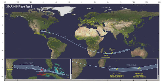
Reconstructing the approximate reentry and disintegration position of Starship FT3 [UPDATED]

click map to enlarge

Starship Flight Test 3 (see this earlier pre-launch post) was largely a success. Starship FT 3 launched from Boca Chica at 13:25 UTC (March 14, 2024) and was successfully inserted on a sub-orbital trajectory. The stage separations went well, coasting went well, and so did various other attempted milestones (such as briefly opening the cargo bay doors in space). 

There were a few small mishaps: an attempt to make a controlled water-landing of the first stage went awry, and so did the final controlled reentry attempt of Starship itself over the Indian Ocean. But in all, this was a successful test flight, providing exciting imagery during the launch and flight to boot (see end of this post).

In this post, I will try to reconstruct the approximate points of reentry: the point (at 100 km altitude) where the reentry plasma formation started, and the point were telemetry was lost (and Starship presumably disintegrated, at 65 km altitude).

The base of my reconstruction is this pre-launch TLE that I constructed for launch at 13:25:00 UTC:

STARSHIP FT3                 for launch on 14 March 2024 13:25:00 UTC
1 70000U 24999A   24074.55902778  .00000000  00000-0  00000-0 0    03
2 70000 026.3000 177.8817 0153183 289.7760 142.6230 16.45958778    07

I was able to check and calibrate this elset, making use of a prominent landmark on earth visible in the webcast just before reentry started. 

At Mission Elapsed Time (MET) 00:44:09, corresponding to 14:09:09 UTC, Lake Anony on Madagascar can be briefly seen:
 

screenshot from the SpaceX webcast at MET 00:44:09 showing Lake Anony 

The geographical area in question in a Google Earth image


This allowed to check with the trajectory based on my pre-launch estimated TLE. It shows that my TLE estimate basically puts the trajectory in the correct position, but that it is 27 seconds "late" on the real flight path, and a bit too low in altitude.

Two minutes later, at MET 00:46:17 (corresponding to 14:11:17 UTC), at 100 km altitude, the first clear reentry plasma can be seen forming as a red glow around the fins of Starship. This is reference point one:


Screenshot from SpaceX webcast. Click image to enlarge

Slightly over 3.5 minutes later, at 65 km altitude at MET 00:49:40  (corresponding to 14:14:40 UTC), telemetry is lost, and this presumably is where Starship disintegrated. This is reference point number two.

Knowing that my pre-launch TLE is 27 seconds "late", we can deduce approximate positions for reference point one (start of plasma formation) and reference point two (loss of telemetry and presumed disintegration) using the TLE.

They are at respectively 26.30 S, 55.68 E for the start of the Plasma formation, and 26.10 S, 70.87 E for telemetry loss and presumed disintegration, as indicated by the two yellow circles in the map below:


click map to enlarge


This also confirms that the controlled reentry aimed for the western part of the HYDROPAC 833/24 hazard zone (see discussion in my earlier pre-launch post here), as suggested by Jonathan McDowell, and that the eastern part of that zone was safety overshoot in case the controlled deorbit burn failed and Starship would continue on a ballistic trajectory.


UPDATE  15 March 2024 18:30 UTC:

I reanalysed the trajectory, using altitude data from the SpaceX webcast to create a TLE that matches the altitude against Mission Elapsed Time (MET), fits the hazard areas from the Navigational Warnings, and results in a pass south of Lake Anony in Madagascar at the correct MET:


STARSHIP FT revised elset                                -50 x 235 km
1 70012U 24999A   24074.55902778  .00000000  00000-0  00000-0 0    06
2 70012 026.3000 177.8795 0220000 355.7000 077.5000 16.67947166    01


As can be seen in the diagram below, this elset has a close fit to the altitudes from the SpaceX webcast (the blue dotted line is a polynomial through the altitudes from the webcast; the red crosses are the altitudes given by the TLE):

click diagram to enlarge


The resulting position for reference point one (start of plasma formation) is 26.28 S,  55.57 E. The resulting position for reference point two (loss of telemetry and presumed disintegration) is 26.13 S,  70.51 E.

click map to enlarge

The point where, 00:08:35 after launch, Starship started its coasting phase after engine cut-off is 24.491 N, 84.633 W (150 km altitude).

[end of update]

A few more images of the launch (screenshots from the SpaceX webcast):


screenshots from SpaceX webcast

Wednesday 13 March 2024

Starship Flight Test 3 upcoming

click map to enlarge

Pending FAA approval (i.e., the launch date might well be postponed), SpaceX aims to launch Starship Flight Test 3 this week. Navigational Warnings issued indicate a window opening at 12:00 UTC on March 14, 2024.

The flight trajectory differs from the previous two ill-fated test flights (which both disintegrated early in flight, see an earlier post here concerning FT 2). 

FT 1 and FT 2 targetted a splashdown near Hawaii after slightly less than one full orbital revolution. FT 3 however has a much shorter flight path, aiming to splash down in the Indian Ocean west of Australia after half a (sub-) orbital revolution.

The map above shows the hazard zones for the launch, from Navigational Warnings NAVAREA IV 278/24 and HYDROPAC 833/24, and the flight trajectory these indicate. Numbers next to the trajectory represent the approximate flight time in minutes after launch.

The hazard zone in the Gulf of Mexico differs from that of FT 1 and FT2  by being much more extended (perhaps a lesson from the last in-flight disintegration with fragments splashing down far downrange, near the Bahamas and the Dominican Republic: see an earlier blogpost here). It also has a remarkable shape - my tendency for pareidolia kicks in and sees a Plesiosaur in it. I wonder what the protrusions mean, especially the one near Florida and Cuba that appears to suggest a backwards motion. 

The reentry and splash-down hazard zone at the end of the flight path spans almost the full width of the Indian Ocean, starting near Madagascar and ending near Australia.

I estimate the following (sub-) orbit for the flight test:


STARSHIP FT3                 for launch on 14 March 2024 13:25:00 UTC
1 70000U 24999A   24074.55902778  .00000000  00000-0  00000-0 0    03
2 70000 026.3000 177.8817 0153183 289.7760 142.6230 16.45958778    07


 SpaceX has some ambitious aims for this flight test, which according to their website (as retrieved 13-03-2024) include:


"the successful ascent burn of both stages, opening and closing Starship’s payload door, a propellant transfer demonstration during the upper stage’s coast phase, the first ever re-light of a Raptor engine while in space, and a controlled reentry of Starship"


Let's however await first whether it actually does not have a RUD ('Rapid Unscheduled Disintegration') again early in flight, as FT 2 did... 

Note added 14 March 2024 9:50 UTC:

Jonathan McDowell has suggested to me that the controlled reentry likely aims for the western part of the Indian Ocean hazard zone from HYDROPAC 833/24, with the eastern part being a safety overshoot in case the deorbit fails. That makes sense to me.


Sunday 10 March 2024

A so far unidentified object in GEO near PAN and Eutelsat Hot Bird 13B [UPDATED]

PAN on March 4, 2024 (click image to enlarge)
UNID near PAN on March 8, 2024 (click image to enlarge)

In the evening of March 8 I did some observations to check upon the drifting PAN/NEMESIS-1 satellite. To my surprise, there was another object there that is not in the current catalogue (as of 10 March 2024). It wasn't there yet when I imaged the area 4 days earlier, in the evening of March 4, as can be seen by comparing the two images above.

Most likely this UNID is some commercial geosynchronous satellite that has been relocated without the 18th STS having caught that move yet. But it could also be something new. For now, it remains unidentified.

The UNID is located at about 33.8 E longitude. A very provisional elset:


UNID ML080324
1 99999U 24000X   24068.68698391 0.00000000  00000-0  00000-0 0    03
2 99999   0.0001  87.9800 0002372 229.7255 130.2564  1.00270000    07


The object could perhaps be the newly launched Chinese satellite WHG-01 (2024-040A). It was launched from Xichang a week ago, on 29 February 2024. Currently (March 11, 2024), only an 8-day old GTO elset is available for the object. That elset combined with the elset for the UNID above suggests that the satellite could have been inserted into GEO at 33.8 E on March 6 near 11 UTC.

Over the half hour arc that I imaged it on March 8, the UNID remained stationary. 

PAN/NEMESIS-1 is meanwhile slowly drifting west (the drift can be seen in the images above too, by comparing the distance of PAN/NEMESIS-1 to EUTELSAT HOT BIRD B13), as it has been doing for quite a while now. On 2024 March 8 it was near longitude 33.45 E. It is currently drifting at a rate of approximately -0.03 degrees per day.


PAN longitude of subsatellite point over time (click diagram to enlarge)

NOTE: an initial mix-up of the names of two recently launched Chinese GEO sats was corrected.


UPDATE 14 March 2024:

Space-Track, since yesterday (first non-GTO TLE has epoch 24073.71736125 = 13 March 2024 17:13 UTC), finally also places an object  in this position, catalogue nr 59069, COSPAR 2024-040A. Provisionally named "Object A", but the Cospar code indicates this would indeed be the Chinese satellite WHG-01.

The ISS EP9 battery pack observed on its last revolution before reentry

ISS EP9 battery imaged on 8 March 2024 18:17 UTC (click image to enlarge)

On 11 January 2021, a 2.6-tons car-sized container with old NiH batteries was detached from the International Space Station using the Canadarm2 robotic arm, and released into space. The object, called "ISS DEB (EP BATERRY)" by CSpOC, catalogue number47853, COSPAR 1998-067RZ, had since been slowly coming down for an uncontrolled reentry.

This reentry happened on 8 March 2024, at 19:29 +- 1 m UTC according to CSpOC, near 22 N, 85.5 W, over Yucatan and the western Caribean (the +-1 minute time uncertainty indicates that this is likely based on a SBIRS satellite detection of the reentry fireball).

Earlier similar packs of discarded NiH batteries were taken onboard visiting HTV supply spacecraft, to return and burn up in a controlled reentry with the HTV. For this last pallet, no HTV was available anymore, hence why it was unceremoniously tossed into space for a natural, uncontrolled reentry.


Canadarm2 releasing the container with NiH batteries into space (image: NASA)

In Germany, for some odd reason the news of the imminent reentry lead to a minor scare, with the German government issuing an alert through their cellphone civilian alert system, as the object would briefly pass over Germany within the (at that time almost a day wide!) reentry uncertainty window.

This alert was unnecessary in my opinion: yes, this was not a small object, and more solid than a rocket stage, but still, objects this size and mass and even bigger reenter several times a month - this was not an unusually large piece of space debris reentering. The very weekend following on this reentry for example, a 5-tons Chinese rocket stage, i.e. twice as heavy, would have an uncontrolled reentry as well. 

Chances of the pallet with discarded batteries coming down over Germany were less than 1%, and even if it would have done so, it would break up into much smaller pieces during reentry, and most of these would burn up in the atmosphere. Some pieces might survive and reach Earth surface, as with any reentry of a somewhat larger object, but the hazard is relatively small and is not of catastrophic proportions. Using the civilian alert system for catastrophies to issue alerts was panic-football, in my opinion, and it unnecessarily spread fear

Maybe it was meant to avoid panic in case of a reentry - with a spectacular light show in the sky and possible sonic booms - over Germany: but this alert reached the opposite I feel, creating unrest rather than avoiding it.

On its last orbit, slightly over an hour before reentry, I imaged the object passing over Leiden, the Netherlands around 18:17 UTC (March 8: 19:17 local time), as can be seen in the image above. This was in early twilight.

The object was moving very fast, zipping across the blue twilight sky, and bright: at magntiude -1 to -2 brighter than the brightest stars in the sky. I had no trouble seeing it naked eye. The image in top of this post is a 1/25th second exposure showing it passing through the constellation Auriga, almost right overhead (the bright twilight sky combined with a fast wide angle lensnecessitated a short exposure time).

A day earlier, on March 7th when all the anxiety in Germany erupted, I filmed it under terrible observing conditions (clouds came in just as the object was about to pass), where it was bright enough to shine through the clouds: