Friday, 8 December 2023

A Missile Defense Test in the NE Pacific on December 11-16 (FTG-12?)

click map to enlarge
 

Two Navigational Warnings have appeared, NAVAREA XII 841 and NAVAREA XII 845, that together point to a Missile Defense test with a MRBM/IRBM target missile fired from NW of Hawaii towards California, and intercept by a GBI fired from Vandenberg, California. 

The window runs from December 11  to December 16 (2023). Here are the Navigational Warnings:

 061011Z DEC 23
NAVAREA XII 841/23(19).
EASTERN NORTH PACIFIC.
NORTH PACIFIC.
1. HAZARDOUS OPERATIONS 1430Z TO 1730Z DAILY
   11 THRU 16 DEC IN AREAS BOUND BY:
A. 24-40.00N 164-32.00W, 24-52.00N 164-43.00W,
   24-38.00N 165-07.00W, 24-26.00N 164-57.00W.
B. 27-13.00N 158-33.00W, 27-34.00N 158-49.00W,
   27-07.00N 159-45.00W, 26-44.00N 159-30.00W.
2. CANCEL THIS MSG 161830Z DEC 23.//


070807Z DEC 23
NAVAREA XII 845/23(18,19).
EASTERN NORTH PACIFIC.
CALIFORNIA.
1. HAZARDOUS OPERATIONS 11 THRU 16 DEC:
   A. 1400Z TO 1805Z DAILY IN AREA BOUND BY
      35-01.00N 121-13.00W, 35-01.00N 120-29.00W,
      34-45.00N 120-29W.00, 34-44.00N 121-13.00W.
   B. 1400Z TO 1805Z DAILY IN AREA BOUND BY
      34-35.00N 123-56.00W, 35-07.00N 123-56.00W,
      35-08.00N 121-13.00W, 34-36.00N 121-13.00W.
   C. 1400Z TO 1753Z DAILY IN AREA BOUND BY
      34-28.00N 126-07.00W, 35-11.00N 126-09.00W,
      35-12.00N 125-20.00W, 34-29.00N 125-18.00W.
   D. 1400Z TO 1846Z DAILY IN AREA BOUND BY
      35-08.00N 137-34.00W, 35-48.00N 128-26.00W,
      33-43.00N 128-13.00W, 32-52.00N 136-37.00W.
   E. 1400Z TO 1900Z DAILY IN AREA BOUND BY
      32-59.00N 138-18.00W, 34-45.00N 138-38.00W,
      35-06.00N 135-41.00W, 33-19.00N 135-25.00W.
2. CANCEL THIS MSG 162000Z DEC 23.//


As pointed out by Twitter user @M51_4ever, this could be test FTG-12, planned for the 4th quarter of 2023. It is a Ground Based Interceptor (GBI) test (part of the Ground Based Midcourse Defense (GBMD) system) where only two of the three stages burn, allowing an intercept at closer range (see also here).

The target missile appears to be a MRBM/IRBM fired from (probably) an aircraft in the vicinity of the fantastically named  French Frigate Shoals. The French Frigate Shoals is a reef/atoll in the Northwestern Hawaii islands, about halfway between Hawai'i and Midway, which got its name from the fact that two Frigates from the ill-fated late 18th century French LapĂ©rouse expedition (which is a name that should be familiar to any Jules Verne fans) nearly were lost there.

My interpretation is that the intercept will be about 1000 km out of the California coast, over area D from NAVAREA XII 845 (Area E probably is where stage 2/3 and any remains of the kill vehicle will come down). The target missile will fly some 3300 km before being intercepted (or not: previous tests had an about 1 in 2 miss chance).

In the map in top of this post, blue is the target missile, red the interceptor.

Wednesday, 6 December 2023

Navigational Warnings for USSF-52 (X-37B OTV 7) have appeared [UPDATED]


click map to enlarge
 

revised post, last updated 12 Dec 2023 18:30 UTC

Navigational Warnings (NAVAREA IV 1414/23) have appeared which I believe are for USSF-52, the launch of X-37B mission OTV 7 (see also this earlier blogpost), on December 11.

This is the text of the Navigational Warning

061024Z DEC 23
NAVAREA IV 1414/23(GEN).
WESTERN NORTH ATLANTIC.
FLORIDA
1. HAZARDOUS OPERATIONS, ROCKET LAUNCHING
   110001Z TO 110431Z DEC, ALTERNATE
   0001Z TO 0431Z DAILY 12 THRU 17 DEC
   IN AREAS BOUND BY:
   A. 28-39.16N 080-37.80W, 29-12.00N 079-57.00W,
      29-10.00N 079-55.00W, 28-36.00N 080-15.00W,
      28-29.00N 080-24.00W, 28-27.60N 080-31.55W,
      28-27.94N 080-31.75W.
   B. 30-30.00N 078-35.00W, 30-58.00N 078-09.00W,
      30-52.00N 077-58.00W, 30-24.00N 078-23.00W.
   C. 36-07.00N 071-37.00W, 38-06.00N 069-34.00W,
      38-17.00N 068-32.00W, 38-13.00N 068-27.00W,
      37-32.00N 068-50.00W, 35-58.00N 071-28.00W.
2. CANCEL THIS MSG 170531Z DEC 23.//


It defines three areas: the immediate launch zone and side booster return corridor (A); the fairings splashdown zone (B); and the core stage return zone (C).

The initial launch azimuth results in an orbital inclination of about 48.25 degrees. I am however inclined to think that a dogleg might be involved at some point, and the real target inclination might be ~64 degrees.

From various leads it was speculated that USSF-52/OTV 7 might go into a high orbit, unlike previous OTV missions which al went to the lower reaches of Low Earth Orbit. Among the reasons for this speculation are the choice for a Falcon Heavy rather than Falcon 9, a mention of "new orbital regimes" in a recent US Space Force news bulletin on USSF-52, and a mention of a GTO orbit in a 2017 procurement document for the launch (see this earlier blogpost).

The core booster return zone is at some 1500 km from the launch site, which is a distance similar to what we have seen with launches into GTO, such as USSF-44. The launch azimuth however clearly does not match a GTO orbit.

But it all does point to a high apogee orbit. This indicates that perhaps a ~64 degree inclined HEO is targetted. No Navigational Warnings have yet appeared for the second stage (but they might appear later, closer to launch [edit 8 December: as they did! see update below]), which could indicate it will stay on orbit, which also points to a high apogee.

All kinds of speculations are possible, up to the possibility of a service/inspection mission to one of the NRO assets in HEO. Looking at the launch window and orbital plane positions, potential targets then could be USA 179 and USA 184. [update: as the apogee looks to be over the southern hemisphere, this does no longer look very likely though)

It will be interesting to see in what orbit it eventually goes, although with all, uncertainty it might be difficult to locate once on-orbit.

The map in top of this post depicts two scenarios: one for direct orbit insertion into ~48 degrees inclined HEO, and one for a ~185 km coasting orbit.  

EDIT: the map below provides a newly developed scenario aiming for HEO.


UPDATE 8 December 2023:

Indeed, a second Navigational Warning, NAVAREA XII 846/23, has now appeared, that seems to define the second stage deorbit zone. It confirms that after launch, at some point a dog-leg is done with the 2nd stage pushing the payload into a higher inclination orbit - the shape and direction of the area suggests a 74-degree inclined orbit.

071019Z DEC 23
NAVAREA XII 846/23(16,17,19).
EASTERN NORTH PACIFIC.
1. HAZARDOUS OPERATIONS, SPACE DEBRIS
   110001Z TO 111615Z DEC, ALTERNATE
   0001Z TO 1615Z DAILY 12 THRU 17 DEC
   IN AREA BOUND BY
   51-04N 152-41W, 53-27N 141-07W,
   41-40N 136-32W, 38-43N 146-53W  
2. CANCEL THIS MSG 171715Z DEC 23.//


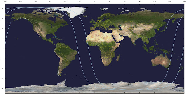
I am not entirely certain about the scenario which follows next: but one scenario that fits is initial launch into a 48-degree inclined low orbit, a brief coast, and then 20-25 minutes after launch, over the NE Atlantic, a burn that doglegs the payload into a 74-degree inclined Highly Elliptical Orbit with apogee near 35188 km. This would have the second stage return to perigee (where it can be deorbitted) over the area defined by NAVAREA XII 846/23 at the end of the first revolution. See map below.

(the trajectory in the map below is so weirdly curved, rather than the usual sinusoid, because it is a ground-projection of the 2.3 rev/day HEO trajectory).

click map to enlarge

The resulting HEO is somewhat unusual: 74 degrees inclined (rather than the typical 64-degree Molniya orbit) and with apogee over the southern hemisphere. I am not sure my reconstruction is correct and am open to other suggestions.

USSF-52 OTV 7                for launch on 11 December 2023 01:18 UTC
1 70000U 23999A   23345.07222222  .00000000  00000-0  00000-0 0    08
2 70000 074.0000 314.2121 7272705 135.6501 359.9903 02.32559366    04

Launch time will reportedly be 01:18 UTC (December 11)


SECOND UPDATE, 11 Dec 19:00 UTC:

The launch has slipped one day, to 12 December 1:14 UTC. And I have revised my orbit estimates, based on new Navigational Warnings (specifically NAVAREA XII 854/23), that put new time constraints that might indicate that the apogee altitude that is higher than my initial estimate:

USSF-52 OTV 7                  for launch on 12 Dec 2023 01:14:00 UTC
1 70000U 23999A   23346.07013889  .00000000  00000-0  00000-0 0    06
2 70000 074.0000 325.5453 7407989 135.5462 360.0000 02.15472011    09

This orbit has the second stage arrive over what I interpret as the second stage deorbit area around the opening time of  Navigational Warning NAVAREA XII 854/23 (corrected for the shift in launch time between December 11 and 12):

081805Z DEC 23
NAVAREA XII 854/23(16,17,19).
EASTERN NORTH PACIFIC.
1. HAZARDOUS OPERATIONS, SPACE DEBRIS 
   111253Z TO 111354Z DEC, ALTERNATE 
   1252Z TO 1354Z DAILY 12 THRU 17 DEC 
   IN AREA BOUND BY
   51-34.00N 141-57.00W, 49-51.00N 150-42.00W,
   40-55.00N 146-02.00W, 42-38.00N 138-36.00W.
2. CANCEL NAVAREA XII 846/23.
3. CANCEL THIS MSG 171454Z DEC 23.

The resulting orbit with apogee near 37700 km has a daily precession of 4m 22s, matching the 4-minute shift in launch time between december 11 and 12.

This is the resulting trajectory (see also earlier discussion above):

click map to enlarge


Below is the approximate initial coasting orbit, before the dogleg to HEO: I slightly revised it to an orbital inclination of 51.5 degrees so that it lines up better with the core stage return area C (my initial estimate was based on Area A only):


USSF-52 initial parking orbit  for launch on 12 Dec 2023 01:14:00 UTC
1 70001U 23999A   23346.05138889  .00000000  00000-0  00000-0 0    03
2 70001 051.5000 354.4138 0011414 048.2332 322.9851 16.30015116    06

Note that this all strongly hinges on whether the area defined by NAVAREA XII 854/23, south of Alaska, is indeed related to USSF-52 and not something else...


THIRD UPDATE 12 Dec 18:30 UTC

The launch was again postponed and is now slated for no earlier than 14 December 1:13 UTC.

Here are revised elset estimates:

USSF-52 OTV 7                  for launch on 14 Dec 2023 01:13:00 UTC
1 70000U 23999A   23348.06875000  .00000000  00000-0  00000-0 0    08
2 70000 074.0000 315.9156 7272705 135.6501 359.9903 02.32559366    00

USSF-52 coasting orbit         for launch on 14 Dec 2023 01:13:00 UTC
1 70001U 23999A   23347.05069445  .00000000  00000-0  00000-0 0    05
2 70001 051.5000 355.1488 0011414 048.2332 322.9851 16.30015116    02


click to enlarge

Saturday, 25 November 2023

North Korea's Malligyong-1 satellite and imaging Guam [UPDATED]

image: KCNA


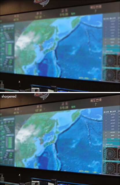
Colin Zwirko of North Korea News brought the image above to my attention. It accompanies a KCNA news bulletin about a visit of Kim Jong Un to the NADA Control Center in Pyongyang, on November 22, about half a day after launch of the Malligyong-1 satellite.

Colin pointed out that you can just make out what appears to be a satellite ground-track on the blurred map on display in the control center.

In the KCNA bulletin, it is claimed that KJU, during his visit to the center:

"watched the aerospace photos of Anderson Air Force Base, Apra Harbor and other major military bases of the U.S. forces taken in the sky above Guam in the Pacific, which were received at 9:21 a.m. on Nov. 22."

At 9:21 am local time in Pyongyang (00:21 UTC) on November 22, Malligyong-1 was indeed just appearing over the horizon at, and coming in radio reach of, NADA Control Center, having passed over Guam seven minutes earlier, near 9:18 local time in Pyongyang (00:18 UTC). At 9:25:27 local time (00:25:27 UTC), the satellite was closest in range to the NADA Control Center (I mention this as it becomes relevant later).

These three images below show the ground-track and position of Malligyong-1 and its footprint (the area that has the satellite above the local horizon) for the moment it passed over Guam (00:18 UTC); for the claimed moment North Korea received images (00:21 UTC); and for the moment of closest range to the NADA Control Center (00:25:27 UTC):


So theoretically, it is indeed possible that Malligyong-1 made images of Guam near 00:18 UTC, and relayed these to the NADA Control Center a few minutes later, starting around 00:21 UTC when it came into radio reach of the latter.

(note added 3-12-2023: this could perhaps indicate it only broadcasts a signal when in range of Pyongyang. This would explain why people like Scott Tilley and me have not been able to find it active in radio frequencies: it is imperative that radio operators in Japan and South Korea try if they can find it active. First try the lower reaches of UHF, i.e. 400-500 MHz, as that is where for example the Iranian Nour satellites broadcast and we know there are connections between the N-Korean and Iranian rocketry programs).

The line on the map on display in the NADA Control Center in the KCNA image conforms to the Malligyong-1 pass in question. A bright dot on the track over the Sea of Japan seems to closely conform to the point of closest range to NADA CC, around 00:25:27 UTC (see also the animated GIF further down in this blogpost):

click to enlarge

Compare to this map I made of the Malligyong-1 ground-track around that time:

click map to enlarge

In this animated GIF, I have superposed both maps, showing the match:


This however does not necessarily mean that North Korea indeed obtained imagery of Guam on this pass, as is claimed in the KCNA bulletin.

Usually, a satellite goes through a checkout-phase first before becoming fully operational. Solar panels and antenna's have to be unfurled, systems started up and checked, attitude and pointing brought under control, camera's calibrated. This check-out phase usually takes days to weeks. Having imagery within hours, would be quite fast.

So unless North Korea publishes the imagery, it remains conjecture whether the claim is true or just propaganda.

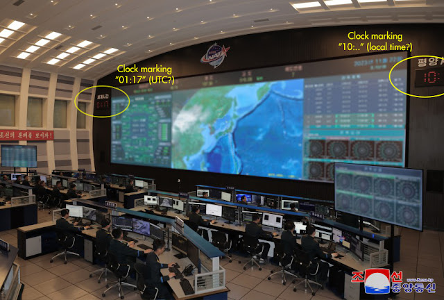
One final thing to remark: if the image in the NADA Control Center was indeed taken during KJU's visit around 10 am local Pyongyang time (according to KCNA) on November 22, this means it was taken before orbits of Malligyong-1 became publicly available. The first public available, US released orbit is of epoch 00:14 UTC on the 22nd, but was not released untill 3:26 UTC, some 2.5 hours after KJU's visit and, it appears, some two hours after the image in the NADA Control Center was taken.. 

click to enlarge

Two clocks are visible in the photograph that would indicate it was indeed taken during KJU's visit, around 1:17 UTC, and therefore before public release of orbital elements: one partial clock can be seen on the right, marking "10:.." in likely local time, the other on the left can be seen in full and is marking "01:17" in what is likely UTC (maybe someone fluent in Korean could confirm what the Korean text above the clock says?).

The image would then date to about 1 hour after any imagery of Guam was obtained.

The orbit on the map in the NADA Control Center conforms to the real orbit in detail, suggesting (if we take face value that the photograph was taken at 01:17 UTC) that North Korea did have either their own tracking data or a telemetry-derived orbit already before the US tracking network published the first public orbits. (while some might say this is perhaps not surprising, and I agree, I mention it because there are still those who question any indigenous capacity North Korea might have when it comes to their missile and space program)

It is of course possible that the image in reality was shot at a later moment, after the orbital elements were publicly released, and the clocks doctored (I mention this as North Korea has a history of doing this kind of stuff).

UPDATE 27 Nov 2023:

On November 25, a new KCNA bulletin mentions a second visit of Kim Jong Un to the NADA Control Center that day where he "watched the photos of major target areas in the enemy region, including Jinhae, Pusan, Ulsan, Phohang, Taegu and Kangrung, taken by the reconnaissance satellite from 09:59:40 to 10:02:10 a.m.".

Specifically are mentioned, photographs: 


"taken by the reconnaissance satellite at 10:01:10 shows the U.S. Navy nuclear carrier Carl Vinson, which is anchored at the military port in Ryongho-dong, Nam-gu of Pusan City"

...and photographs of the: 

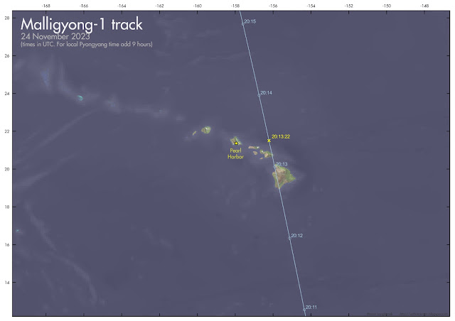
"naval base in the Pearl Harbor, the Hickam air-force base in Honolulu and other objects, taken by the reconnaissance satellite while passing over Hawaii of the U.S. at 05:13:22 a.m. on Nov. 25 in Pyongyang time"

Again, the quoted times match the closest approach points on actual passes over/near these targets, as can be seen in the maps below. And the USSN Carl Vinson is in Busan (Pusan) harbor, as Jeffrey Lewis pointed out on Twitter (this does not necessarily mean they have this info of satellite imagery of course).

(in the maps below, quoted times and dates are in UTC. To get Pyongyang local time, add 9 hours).

click map to enlarge

click map to enlarge

Wednesday, 22 November 2023

North Korea successfully launches the Malligyong-1 reconnaissance satellite

image: KCNA


On 21 November 2023 at 13:42:28 UTC, according to the State News Agency KCNA, North Korea succesfully launched its new Malligyong-1 military reconnaissance satellite to orbit. The launch was from Sohae platform 2 using a (also new) Chollima-1 rocket. 

This was the third launch attempt. Two earlier attempts, on May 31 (see this blogpost) and August 23 (see this blogpost) failed to reach orbit due to malfunctions of respectively the second and third Chollima stages.

Yesterday's sucessful launch happened 1h 18m before the window from the published Navigational Warning HYDROPAC 3667/23 (see earlier blogpost here) opened, hence taking everybody by surprise.

KCNA reports that orbit insertion was at 13:54:13 UTC.

The US Military Space Tracking network CSpOC has published orbits for two objects resulting from this launch, confirming the North Korean claim of a successful orbit insertion

Object A (nr 58400, 2023-179A) is likely the payload, Malligyong-1, and is in a 97.43 degree inclined, 512 x 493 km sun-synchronous orbit

Object B (nr 58401, 2023-179B) is likely the Chollima-1 upper stage and is in a 97.41 degree inclined, 512 x 467 km orbit.

The orbit of the payload is a Sun-synchronous orbit with a repeating ground track. It results in daily transits over Pyongyang around 10:00 and 22:00 local time, with a ground track that repeats itself each five days. This is consistent with a function as an optical reconnaissance satellite.


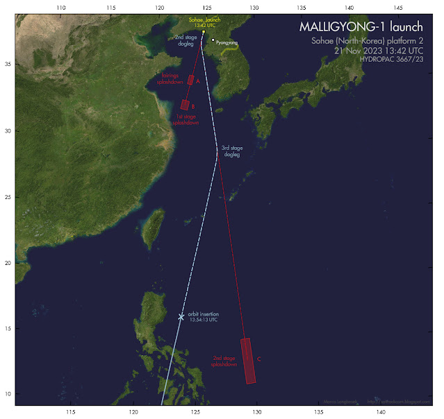
I analysed the orbital trajectory in relation to the positions of the hazard zones from Navigational Warning HYDROPAC 3667/23. 

Earlier this year, in connection to the first launch attempt, there was a discussion whether: 

(1) a multiple dogleg was involved, or;

(2) a direct orbit insertion with post-separation restart and dogleg manoeuvering of the second stage, or;

(3) a dogleg manoeuvre of the second stage pre-separation with insertion into a 78-degree inclined non-SSO orbit. 

The reason for the discussion, was that the splashdown area for stage 2 east of the Philippines, was out of line with the splashdown areas for stage one and the fairings. The direction marked by the splashdown areas for the first stage and fairings would actually match a direct SSO insertion. A detailed discussion of the issue is in this previous blogpost on the May launch attempt.

We now have an answer, based on the position of the orbit at orbit insertion: a double dogleg by both the second and third stages was involved, as illustrated below:

click map to enlarge

After separation from the first stage, stage two made a dogleg eastward. After separation from the second stage, stage three then made another dogleg westward, and next brought the payload to the orbit insertion point, the stage itself also attaining orbit in that process (where it is now space debris).

(note: the manoeuvers were likely a bit less 'sharp' than in the illustration above)

The resulting orbit is basically what would have been achieved with a direct insertion along the original launch azimuth, but with the RAAN shifted by 4.2 degrees. The double dog-leg was probably chosen to avoid the second stage falling too close to the Philippines or (in case it underperformed) on China or Taiwan.

[update] Some interesting footage has appeared on the internet from a South Korean all-sky meteor camera operated by Yonsei University. It shows the first and second stage, with the first stage blowing up after separation of the second stage. This could well have been deliberate (to avoid intact hardware recovery by South Korea: or because of range safety), but can also have been accidental (see for example how the Starship stage 1 accidentally blew up just a few days earlier). [end]

Here are a few photo's of the launch, from the North Korean State News Agency KCNA:


"Thar She Goes! No Kablooih this time!"

Tuesday, 21 November 2023

North Korea to try a third time to launch its Chollima-1 rocket and Malligyong-1 satellite coming days [UPDATED]

click map to enlarge

UPDATE 21 Nov 2023:  

North Korea launched the satellite on 21 Nov 13:42 GMT (1h 18m before opening of the window from the Navigational Warnings!) and claims the launch was successful.


A Navigational Warning, HYDROPAC 3667/23, has appeared today that suggests that North Korea will do a third attempt to launch their new military reconnaisance satellite Malligyong-1 on their new Chollima-1 space launch vehicle the coming days, perhaps as early as to morrow 21 November.

They tried twice before: on May 31 (see this blogpost) and on August 23 (see this blogpost). During the first attempt on May 31 the second stage failed; during the second attempt on August 23, the third stage self-destructed. Maybe they will get it right this time.

The launch window runs from November 21 15:00 UTC to November 30 15:00 UTC, based on the Navigational Warning.

The locations of the three hazard areas from the Navigational Warning are similar to those for the May and August launch attempts: Areas A and B (fairings and first stage splashdown) are southwest of Sohae in the direction towards China and Taiwan, and Area C, the second stage splash-down area, is east of the Philippines. See the map above. 

As discussed before in the context of the May launch, the location of Area C suggests that a dog-leg by the second stage is involved: either before third stage release, or after.

This is the text of the Navigational Warning:

201932Z NOV 23
HYDROPAC 3667/23(91,92,94).
EAST CHINA SEA.
PHILIPPINE SEA.
YELLOW SEA.
CHINA.
DNC 11, DNC 23.
1. HAZARDOUS OPERATIONS, ROCKET LAUNCHING 
   211500Z TO 301500Z NOV IN AREAS BOUND BY:
   A. 36-02.44N 123-59.18E, 36-06.94N 123-33.11E,
      35-24.52N 123-22.78E, 35-20.02N 123-48.62E.
   B. 33-58.97N 123-40.07E, 34-05.90N 123-01.99E,
      33-23.47N 122-51.88E, 33-16.54N 123-29.66E.
   C. 15-01.70N 129-24.05E, 14-54.17N 128-40.10E,
      11-19.30N 129-10.84E, 11-26.81N 129-54.13E.
2. CANCEL THIS MSG 301600Z NOV 23.

During the previous two launches, Japan and South Korea acted ridiculously panicky, sounding sirens and telling civilians to take shelter. This is however a pre-announced space launch, not an unannounced ballistic missile launch, on a trajectory that avoids flying over significant pieces of land surface. Sounding sirens and telling people  to take shelter, is an over-reaction. Hopefully they will act less panicky this time, as this kind of panic serves no purpose.

Saturday, 18 November 2023

Where did Starship fragments end up after its in-flight destruction? [UPDATED]

click map to enlarge

 
click map to enlarge


The second SpaceX Starship Integrated Test Flight initially launched successfully on November 18. The spacecraft separated succesfully from the first stage (which however violently disintegrated almost immediately after this). However, at 148 km altitude just before engine shutdown and coasting phase commencement, something went wrong and the spacecraft's auto-destruction mechanism destroyed the spacecraft.

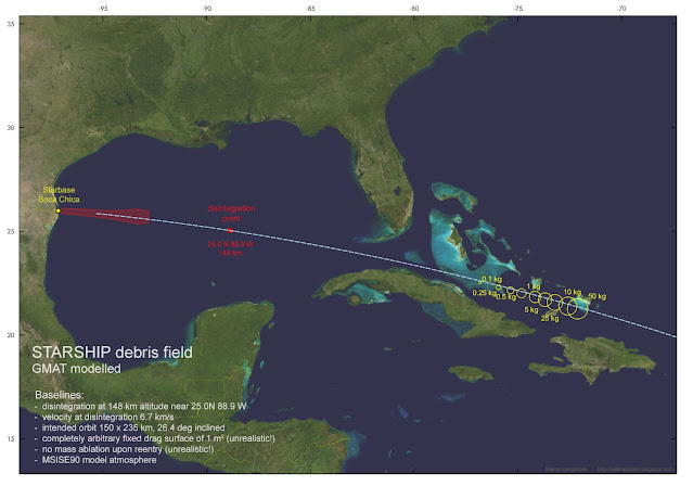
I estimate the point of destruction to be in the middle of the Gulf or Mexico, near 25.0 N 88.9 W, although it could perhaps be slightly more downrange than that, closer to Cuba and Florida.

The question then popped up: how far downrange from the destruction point would any remaining debris end up? The answer to that question strongly depends on amongst others the speed upon destruction, and the sizes and masses of any debris. 

The map in top of this post gives an indication based on a somewhat simplistic modelling attempt, further discussed below.

After some initial educated guesses, I decided to investigate the issue further using a simple model in GMAT (the General Mission Analysis Tool). Live-feed data shown in the webcast from just before telemetry contact was lost indicated a speed of about 6.7 km/s, at 148 km altitude.

Using these base values and my estimated location for the point of destruction, I modelled the resulting vector in GMAT, using the MSISE90 model atmosphere that is part of GMAT. I modelled results for a number of masses, ranging from 0.1 kg to 50 kg, and with a fixed drag surface of 1 m2 for each fragment irrespective of mass. This is not very realistic by the way, but sufficient for a general idea nevertheless.

Another deviation from reality is that there was no further mass loss (e.g. because of ablation upon reentry) of the debris pieces in the model. So, this is a bit a case of a proverbial "spherical cow reentering" (but not in a vacuum: the MSISE90 model atmosphere was used to model atmospheric drag).

Nevertheless, this academic exercise does give a rough idea of where surviving debris might have ended up: likely some 1500 km downrange from the point of destruction, near the southeastern Bahamas, and north of Cuba and the Dominican Republic. see the map in top of this post, depicting the model results.

(I thank Ian Benecken, Scott Manley and Jonathan McDowell for initial discussions and suggestions on twitter. Any mistakes are solely mine)

UPDATES:

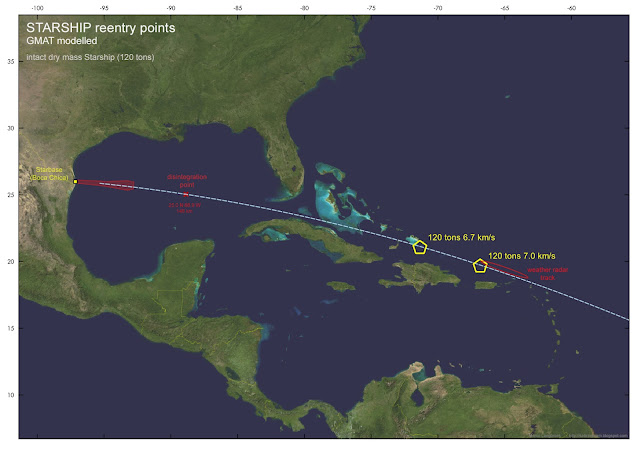
This NOAA weather radar image below by Kenneth Howard (source this tweet by Jonathan McDowell) shows a radar debris trail near Puerto Rico. There is also video footage from Puerto Rico of what looks to be a large Starship remnant reentering and breaking up, see this tweet. This is some 800 km further downrange than the model results, and probably caused by a sizable part of Starship (i.e. considerably larger and heavier than the debris pieces I modelled) disintegrating upon atmospheric reentry.


I modelled an intact Starship upper stage (120 tons dry mass, 63.6 m2drag surface) for two initial speeds at the "disintegration" point: 6.7 km./s and 7.0 km/s. 

The latter value brings it close to where the weather radar depicts the debris trail. This could implicate it was largely intact untill it broke up in the upper atmosphere north of Puerto Rico:

click map to enlarge

Thursday, 16 November 2023

New Starship launch attempt on November 17 approved by FAA [updated]

click map to enlarge

The FAA has issued SpaceX with a licence this week to try a new Starship launch attempt

That attempt is now scheduled for 17 November was initially scheduled for 17 November, but postponed, due to necessary repairs on a grid fin attenuator, to 18 November, with the window opening at 13:00 UTC and running to 15:39 UTC. Back-up dates are Nov 18 to 20.

The test flight is similar to the previous failed one from April 20: launch is from Starbase (Boca Chica) in Texas into a 26.4 degrees inclined orbit with apogee at 235 km, splashdown is just short of one revolution to the NE of Kauai, Hawaii, 1.5 hours after launch. One can debate the semantics on whether the launch is orbital or suborbital.

The map above shows the flight path and the hazard zones from Navigational Warnings NAVAREA IV 1322/23 and HYDROPAC 3578/23 (the text of these warnings is given below)

Most of the flight is over Ocean and chances of sighting the spacecraft while on orbit are slim: passes over land are either in daylight, or with the Starship spacecraft in earth shadow (the latter is the case for e.g. Australia and Indonesia). 

On Kauai and Oahu in the Hawaii islands, the reentry fireball might be seen in the northern sky, if  Starship gets that far.

This is my estimate for the approximate orbit:

STARSHIP                       for launch on 18 Nov 2023 13:00:00 UTC
1 70000U 23999A   23322.54166667  .00000000  00000-0  00000-0 0    05
2 70000 026.3975 054.9842 0064682 110.9574 322.9851 16.30015116    00

These are the relevant Navigational Warnings issued:

132050Z NOV 23
NAVAREA IV 1322/23(11,28).
GULF OF MEXICO.
TEXAS.
1. HAZARDOUS OPERATIONS, ROCKET LAUNCHING
   AND SPACE DEBRIS 1300Z TO 1539Z DAILY 17, 19
   AND 20 NOV AND 181300Z TO 181359Z NOV
   IN AREA BOUND BY
   25-51.00N 096-46.00W, 25-48.00N 096-14.00W,
   25-40.00N 095-03.00W, 25-21.00N 093-15.00W,
   25-26.00N 092-48.00W, 25-58.00N 092-47.00W,
   26-04.00N 093-18.00W, 26-01.00N 094-13.00W,
   26-00.00N 094-48.00W, 26-03.00N 095-43.00W,
   26-06.00N 096-45.00W, 26-07.00N 096-57.00W,
   26-03.00N 097-07.00W, 26-02.00N 097-12.00W,
   25-57.00N 097-12.00W, 25-52.00N 097-01.00W.
2. CANCEL NAVAREA IV 1309/23.
3. CANCEL THIS MSG 201639Z NOV 23

132000Z NOV 23
HYDROPAC 3578/23(19,81,83).
NORTH PACIFIC.
HAWAII TO MARSHALL ISLANDS.
DNC 12, DNC 13.
1. HAZARDOUS OPERATIONS 1410Z TO 1720Z DAILY
   17, 19 AND 20 NOV AND 181410Z TO 181540Z NOV:
   A. ROCKET LAUNCHING IN AREA BOUND BY
      14-26.00N 172-39.00E, 12-55.00N 169-45.00E,
      11-44.00N 167-39.00E, 11-27.00N 167-49.00E,
      11-52.00N 168-58.00E, 12-48.00N 171-10.00E,
      14-29.00N 175-20.00E, 15-24.00N 177-41.00E,
      16-20.00N 179-40.00W, 17-42.00N 175-13.00W,
      19-35.00N 168-59.00W, 21-01.00N 164-29.00W,
      22-32.00N 160-00.00W, 23-35.00N 156-29.00W,
      24-00.00N 155-28.00W, 24-31.00N 155-39.00W,
      24-14.00N 157-43.00W, 23-26.00N 161-55.00W,
      22-44.00N 165-15.00W, 21-54.00N 167-59.00W,
      20-57.00N 170-54.00W, 19-55.00N 173-55.00W,
      19-03.00N 176-19.00W, 17-39.00N 179-59.00E,
      16-13.00N 176-31.00E, 15-36.00N 175-03.00E.
   B. SPACE DEBRIS IN AREA BOUND BY
      24-02.64N 157-33.72W, 24-08.82N 157-02.82W,
      23-32.16N 156-53.28W, 23-25.80N 157-25.56W.
2. CANCEL HYDROPAC 3550/23.
3. CANCEL THIS MSG 201820Z NOV 23.


Let's see whether Starship will reach orbit this time.


UPDATE:

 
Starhip separated succesfully from the first stage this time (which violently disintegrated directly after separation), but Starship's auto-destruction mechanism destroyed the spacecraft just before engine shutdown and orbit insertion, at an altitude of about 148 km.

Thursday, 9 November 2023

Boldly going where no spaceplane has gone before? New X-37B mission OTV 7 to launch in December

X-37B OTV 6 after landing in November 2022 (image: US Air Force)


The US Air Force Rapid Capabilities Office has announced that the 7th mission (OTV 7) of its robotic X-37B Spaceplane will launch, as USSF-52, on 7 December 2023.

The launch will be done from Kennedy Space Center in Florida by SpaceX, using a Falcon Heavy. That is interesting, as it is a surprisingly heavy rocket for this launch: SpaceX has launched an X-37B mission before (OTV 5 in 2017) but using a more modest 'normal' Falcon 9 at that time. So why a Falcon Heavy this time?


X-37B OTV 5 pass photographed by the author on 21 April 2018. Click image to enlarge

In the Air Force announcement, it is stated that the upcoming OTV 7 mission will be "operating the reusable spaceplane in new orbital regimes". That is an interesting phrase in combination with the unusually heavy launch vehicle chosen.

It might imply that this mission will go to a much higher orbit. Indeed, this article in Ars Technica mentions a 5-year-old procurement document which mentions a 27-degree inclined,  35188 x185 km  GTO reference orbit, perhaps implying a mission to GEO (!) or maybe into a Highly Elliptical Orbit (HEO). That would certainly be 'boldly going where no spaceplane has gone before'! If they would launch to GEO and then bring it back, that certainly would be no mean feat.

This will be an interesting mission to track. We will know more when, early December probably, the Navigational Warnings for the launch appear, as these might provide some clues as to the orbit launched into.

Note added 3 December 2023:

The Air Force announcement mentions that the OTV 7 mission includes "experimenting with space domain awareness technologies". I wonder whether, if it is going to geosynchronous orbit, it will test the Silent Barker satellites (launched last September) by functioning as a mock-target.

Imaging Navigation Satellites

All of us have used Navigation Satellites, whether you realise it or not. Our modern western world can no longer function well without them. But it is a challenge to actually see them in the sky. In Medium Earth Orbit (MEO) at altitudes of ~20 000 km, they stay faint.

Four large constellations of Navigation satellites currently exist. The best known is the US GPS system (aka NAVSTAR). But there is also the European GALILEO system; the Chinese BEIDOU system; and the Russian GLONASS system. Together, they are often referred to as the Global Navigation Satellite System (GNSS).

In the evening of 6 November 2023, when the sky over Leiden was very clear, I by chance imaged examples of all four systems, largely within the same small part of the sky, while surveying for HEO objects. Here are some images, one each for each GNSS system (the images were made with a ZWO ASI 6200MM PRO camera and 1.2/85 mm lens, 10-second exposures):


NAVSTAR 73 (GPS)

 
GALILEO 21


BEIDOU 3M7


KOSMOS 2501 (GLONASS)

Sunday, 5 November 2023

Delfi-C3 reentry forecast updates (periodically updated post)


[ Post last updated:  14 Nov 2023  12:45 UTC ]

In my October 25 blogpost I presented imagery of the iconic 3U cubesat Delfi-C3 (2008-021G) taken by my tracking camera. I also provided a reentry forecast in that post, that I updated several times.That reentry is currently (mid November 2023) very near.

I am now consolidating the reentry forecasts in this current, periodically updated blogpost.

While late October the reentry forecast was still shifting to a later date with each orbit update, that shift is now flattening out, but the forecast is still fluctuating. 

A geomagnetic storm that caused aurora at middle latitudes on Nov 5/6 has had a clear effect in speeding up orbital decay (the 'dip' can be seen in the digrams below). Over the weekend 11-12 November, solar activity was more mild than forecast, making the reentry forecast slowly shift to a later time with each orbital update.

My current "aftercast", based on a mid-November 13 orbit modelled in GMAT, is reentry on 13 November 2023, nominally near 20:39h UTC +- 1.5 hours (please note the uncertainty interval!), i.e. between 19 - 22 UTC (and likely  between 20 - 21 UTC)

A SatEvo/SatAna analysis results in a very similar, if slightly earlier, time (nominally 19:34 +- 1.5h UTC). I do not expect it survived to November 14.

The orbit determination on which these 'aftercasts' are based, is from about 3 orbital revolutions before the forecasted reentry moment. This orbit can be of bad quality, as in these final stages, orbit determination is tricky.

Here is how the reentry forecast has been developing so far (note the sudden downward developing trend due to the Nov 5/6 geomagnetic storm):

click diagrams to enlarge


This is probably the last reentry forecast update (or rather "aftercast" by now), as I do not expect new orbital elements to be released between this update and the reentry

(Note: forecast data in tabular form are at the bottom of this post)

This is the Delfi-C3 ground-track over the current uncertainty interval (spanning two orbital revolutions) in the forecast:


click map to enlarge

These reentry predictions are based on a tumbling satellite with, due to the tumbling, an average drag surface of about 60% of the maximum drag surface. Previous experience with modelling reentries in GMAT has shown this to be a reasonable value for a tumbling object. 

What makes these reentry forecasts challenging, and creates the large uncertainties in the reentry position is a combination of things. One is the, even at short timescales, varying solar activity and it's influence on the upper atmosphere, which cannot be well predicted or captured by the model. Second, during the last orbits just before reentry, all kind of gas flow mechanisms around the spacecraft are taking place, which alter tyhe cdrag it expriences. Moreover, in this final stage where the spacecraft meets a more thicker resistance of the upper atmosphere, it sometimes auto-stabilises itself in a least-drag orientation, prolonging survival slightly. Last but not least: in the last moments of the spacecraft's life, when it is in a very low, fast changing orbit, orbit determination becomes difficult, affecting tehe quality of the last orbital elements available for the forecast.

I do not expect a TIP to be issued for this object. TLE updates might end a few hours before the actual reentry, after which CSpOC issues an 'administrative decay'.

Delfi-C3 's orbit had decayed to below 187 x 177 km by mid 13 Nov 2023, and the cubesat was coming down increasingly fast, as can be seen in the diagrams below (the orbit was dropping by almost 100 km/day mid 13 Nov 2023):


click diagrams to enlarge

click diagram to enlarge


Note that Delfi-C3 is very small and lightweight (2.2 kg and 30 x 10 x 10 cm) and the reentry will have been completely harmless. The friction with the molecules in the atmosphere will heat up the spacecraft during its final moments, untill it burns up completely, at altitudes above 50 km. The current ground-track where it can come down, is almost completely over Ocean.

The operators of Delfi-C3 have put out a call to radio amateurs to try to receive and decode telemetry from the cubesat. Software to decode is provided here. The goal is to try to follow Delfi-C3 and get telemetry as close to reentry as possible.

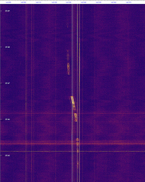
Note that Delfi-C3 only sends telemetry when it is in sunlight, and not continuously as after 15 years the system is showing issues. The frequency is 145.870 MHz, it is sending 1200 Bd BPSK packages. See also here

[EDIT:  as off 11 november, the cubesat seems to have shifted to a backup frequency near 145.934 MHz, as can be seen in this spectogram from my detection in the morning of November 11. The 145.870 MHz frequency is also still intermittently active. So pay attention to both frequencies]


click spectrogram to enlarge

[end of edit]

On the morning  of  Nov 8, during the 7:43 UTC pass, I received thise radio signal of Delfi-C3 from Leiden, the Netherlands (but could not decode the signal), clearly a bit early on the then available TLE:

click image to enlarge


The "stepped" effect is due to attempts to correct the Doppler shift. That Doppler shift (the "s"-shape in frequency due to the Doppler effect in the signal) can be very nicely seen in this spectogram from the same pass as received by my colleagues at Delft University of Technology (image courtesy Bart Root, TU Delft):

click image to enlarge. Image courtesy Bart Root, TU Delft


Radio signals from the cubesat were also received by me and the TU Delft station on later dates, most recently in the morning of November 13th during the 7:24 UTC pass:

Nov 13 ~7:24 UTC radio spectrogram from Leiden. Click image to enlarge

Delfi-C3 is a 3U cubesat developed and built at Delft Technical University in the Netherlands, and launched 15 years ago, in 2008.

More on Delfi-C3 on the website of Delft Technical University. There is also a nice background article on it's 15-year anniversary here.

The last (and only!) visual image of Delfi-C3 on-orbit, taken by me on 24 October 2023 from Leiden, the Netherlands, using a WATEC 902H2 Supreme and Samyang 2.0/135 mm lens at 25 fps (image is a frame-stack of 16 frames: the faint trail lower right is Delfi-C3 moving through the field of view. See also blogpost here which also features some video footage):


TABLE:  Forecast development in tabular form (most recent one at bottom).
All dates and times are in UTC. Quoted times are nominal times, please take into account the uncertainty intervals that go with them!

orbit date         orbit epoch     reentry forecast + uncertainty      
08 okt 2023 13:52  23281.57810544  05 nov 2023 02:23  ±  8.3  day
09 okt 2023 14:28  23282.60344413  05 nov 2023 08:17  ±  8.0  day
10 okt 2023 19:41  23283.82047902  05 nov 2023 11:00  ±  7.7  day
12 okt 2023 00:53  23285.03692402  05 nov 2023 20:20  ±  7.4  day
13 okt 2023 01:27  23286.06083878  06 nov 2023 18:43  ±  7.4  day
14 okt 2023 00:29  23287.02034889  06 nov 2023 18:53  ±  7.1  day
15 okt 2023 08:42  23288.36296159  07 nov 2023 00:59  ±  6.8  day
16 okt 2023 00:02  23289.00204702  07 nov 2023 04:44  ±  6.7  day
16 okt 2023 15:23  23289.64097529  08 nov 2023 02:01  ±  6.7  day
17 okt 2023 18:58  23290.79063916  08 nov 2023 12:14  ±  6.5  day
18 okt 2023 19:29  23291.81212343  08 nov 2023 21:43  ±  6.3  day
20 okt 2023 00:35  23293.02450124  09 nov 2023 16:03  ±  6.2  day
21 okt 2023 01:04  23294.04489630  09 nov 2023 19:49  ±  5.9  day
21 okt 2023 19:26  23294.80984121  09 nov 2023 22:19  ±  5.7  day
22 okt 2023 19:54  23295.82928392  09 nov 2023 23:43  ±  5.4  day
24 okt 2023 07:03  23297.29389307  10 nov 2023 23:54  ±  5.3  day
26 okt 2023 00:17  23299.01200402  11 nov 2023 11:29  ±  4.9  day
27 okt 2023 00:42  23300.02946319  11 nov 2023 12:23  ±  4.6  day
28 okt 2023 01:06  23301.04628230  11 nov 2023 16:02  ±  4.4  day
28 okt 2023 19:24  23301.80847586  11 nov 2023 18:46  ±  4.2  day
30 okt 2023 00:20  23303.01441157  12 nov 2023 09:54  ±  4.0  day
31 okt 2023 00:41  23304.02910990  12 nov 2023 13:04  ±  3.8  day
01 nov 2023 01:02  23305.04306068  12 nov 2023 17:28  ±  3.5  day
02 nov 2023 11:58  23306.49918974  12 nov 2023 17:44  ±  3.1  day
03 nov 2023 07:42  23307.32139835  12 nov 2023 23:36  ±  2.9  day
04 nov 2023 07:58  23308.33247480  12 nov 2023 19:20  ±  2.5  day
05 nov 2023 00:38  23309.02698061  12 nov 2023 21:03  ±  2.4  day
06 nov 2023 00:51  23310.03600547  12 nov 2023 05:15  ±  1.9  day
07 nov 2023 01:02  23311.04321962  12 nov 2023 09:23  ±  1.6  day
07 nov 2023 13:06  23311.54617034  12 nov 2023 14:38  ±  1.5  day
07 nov 2023 14:36  23311.60900895  12 nov 2023 14:25  ±  1.5  day
08 nov 2023 01:10  23312.04868443  12 nov 2023 15:48  ±  1.4  day
08 nov 2023 13:13  23312.55073768  12 nov 2023 19:28  ±  1.3  day
08 nov 2023 19:14  23312.80157938  12 nov 2023 20:14  ±  1.2  day
08 nov 2023 20:44  23312.86427030  12 nov 2023 20:32  ±  1.2  day
09 nov 2023 01:15  23313.05229412  12 nov 2023 21:16  ±  1.2  day
09 nov 2023 13:16  23313.55332040  12 nov 2023 20:49  ±  1.0  day
09 nov 2023 14:46  23313.61590941  12 nov 2023 20:54  ±  1.0  day
09 nov 2023 19:17  23313.80362555  12 nov 2023 21:54  ±  22.4  hr
10 nov 2023 01:17  23314.05377944  12 nov 2023 23:07  ±  20.9  hr
10 nov 2023 14:47  23314.61604116  13 nov 2023 01:14  ±  17.5  hr
10 nov 2023 20:46  23314.86565574  13 nov 2023 01:32  ±  15.8  hr
11 nov 2023 01:15  23315.05274319  13 nov 2023 02:37  ±  14.8  hr
11 nov 2023 13:13  23315.55109903  13 nov 2023 06:40  ±  12.4  hr
11 nov 2023 19:11  23315.79995400  13 nov 2023 08:42  ±  11.3  hr
12 nov 2023 01:09  23316.04856854  13 nov 2023 10:21  ±  10.0  hr
12 nov 2023 14:34  23316.60695182  13 nov 2023 14:53  ±   7.3  hr
13 nov 2023 00:57  23317.03998349  13 nov 2023 17:11  ±   4.9  hr
13 nov 2023 11:18  23317.47133062  13 nov 2023 19:55  ±   2.6  hr
13 nov 2023 12:47  23317.53274184  13 nov 2023 20:06  ±   2.2  hr

FINAL 'aftercast':
13 nov 2023 15:53  23317.65534723  13 nov 2023 20:39  ±   1.5  hr