Sunday 26 March 2023

Missile Spring [updated multiple times]

click map to enlarge

Spring of 2023 seems to be the spring of missile tests. North Korea launched a whole bunch of them, including a Hwasong-17 on March 15. And the USA is testing a number of them: a Hypersonic LHRW test from Cape Canaveral on March 5 that was scrubbed for technical reasons (see my earlier post here): and a now confirmed test of the Hypersonic AGM-183A ARRW on March 13 in the Pacific that does not seem to have gone entirely well either (see earlier post here).

Meanwhile defenses against missiles are being tested too. At least two such Missile Defense tests appear to have been planned for March 2023, judging from Navigational Warnings that have been issued the past weeks.

Mid-March, a Navigational Warning, HYDROPAC 948/23, was issued delineating two hazard zones near Wake island and Kwajalein, in the Pacific, for March 22 (with alternative dates from March 23 to 28) .

They indicate a possible Missile Defense test, likely with a missile fired from Wake island to be intercepted from Kwajalein by a THAAD battery, or vice-versa.

UPDATE 29 March 2023: a press release by Lockheed Martin reveals that this indeed was a Missile Defense test (but not THAAD): an MRBM launched from Wake was intercepted by a PAC-3 (Patriot) missile from Kwajalein.

The two areas from the Navigational Warning are plotted in the map above. The text of the Navigational Warning is below:


131228Z MAR 23
HYDROPAC 948/23(81).
NORTH PACIFIC.
MARSHALL ISLANDS.
WAKE ISLAND.
DNC 12.
1. HAZARDOUS OPERATIONS 222200Z TO 230400Z MAR,
   ALTERNATES 2200Z TO 0400Z DAILY
   23 THRU 28 MAR IN AREAS BOUND BY:
   A. 19-17.00N 166-38.00E, 19-13.00N 166-36.00E,
      18-57.00N 166-36.00E, 18-34.00N 166-41.00E,
      18-35.00N 166-47.00E, 18-58.00N 166-45.00E,
      19-15.00N 166-42.00E, 19-17.00N 166-40.00E.
   B. 10-03.00N 167-38.00E, 10-04.00N 167-47.00E,
      09-27.00N 167-58.00E, 08-44.00N 167-58.00E,
      08-43.00N 167-48.00E, 09-06.00N 167-40.00E.
2. CANCEL THIS MSG 290500Z MAR 23.//


Another Navigational Warning, NAVAREA XII 145/23, has appeared  for an area near Hawaii, that indicates a possible Missile Defense test from the Pacific Missile Range Facility at Barking Sands, Kauai, on March 31 (with backup dates on April 1 and 2).  Below is the hazard area plotted on a map, and the text of the Navigational Warning:


101835Z MAR 23
NAVAREA XII 145/23(19).
NORTH PACIFIC.
HAWAII.
1. HAZARDOUS OPERATIONS 310530Z TO 311100Z MAR,
   ALTERNATE 0530Z TO 1100Z DAILY 01 AND 02 APR
   IN AREA BOUND BY
   24-00.00N 167-37.00W, 26-22.00N 173-34.00W,
   28-08.00N 174-20.00W, 30-40.00N 174-00.00W,
   33-04.00N 168-15.00W, 32-24.00N 162-12.00W,
   30-01.00N 160-25.00W, 26-00.00N 161-20.00W,
   25-56.00N 162-50.00W, 24-26.00N 161-22.00W,
   23-26.00N 160-30.00W, 22-29.00N 159-55.00W,
   22-03.00N 159-45.00W, 22-02.00N 159-46.00W,
   22-11.00N 160-15.00W, 22-45.00N 161-12.00W,
   23-35.00N 162-23.00W, 24-50.00N 164-02.00W.
2. CANCEL THIS MSG 021200Z APR 23.//


[see update below this paragraph] I did not find any Navigational Warnings (yet) for the launch of the target, but it is possible that the target is launched from Kauai and intercepted by an SM-3 or SM-6 fired could from a US Navy ship situated in the hazard area northwest of Kauai. Alternatively, a US Navy ship or aircraft could launch the target in or near the area, with the interceptor being launched from Kauai (which has an AEGIS Ashore test facility). Both scenario's have been used in past tests (e.g. here and here).

[UPDATE 29 Mar 2023: The hazard area from NAVAREA XII 145/23 is identical to that for FTM-31 on 29 May 2021 (Navigational Warning NAVAREA XII 241/21), which was a MRBM target launched from Sandia's facility at Barking Sands Kauai, to be intercepted by two SM-6 missiles fired from a US Navy ship north of Kauai. That test failed)

[UPDATE 1 April 2023: now confirmed to be a Missile Defense test and itapperars to have been a re-run of FTM-31. A MRBM target launched from Kauai was intercepted by two SM-6 missiles fired from the US Navy ship USS Daniel Inouye]

Possibly in connection to this test, a number of tracking ships have been sailing out of Pearl Harbor last week, including the MDA's Sea-Based X-Band Radar:


Wednesday 8 March 2023

Another Hypersonic glider test (likely AGM-183A ARRW) upcoming, in the Pacific [updated]

click map to enlarge

Last weekend saw a scrubbed Hypersonic Missile test from Cape Canaveral, Florida (see a previous post). It looks that another Hypersonic Missile test is upcoming next week, this time in the Pacific in front of California. Lines of evidence point to this Pacific test being another test of the hypersonic AGM-183 ARRW.

This set of three Navigational Warnings (plotted in the map above) have appeared for March 13, 14:00 to 21:00 UTC (with alternative dates from March 15 to 22):

080916Z MAR 23
NAVAREA XII 108/23(18).
EASTERN NORTH PACIFIC.
CALIFORNIA.
1. HAZARDOUS OPERATIONS 131400Z TO 132100Z MAR,
   ALTERNATE 1400Z TO 2100Z DAILY 15 AND 22 MAR
   IN AREA BOUND BY
   33-17.29N 120-27.17W, 33-39.52N 120-59.00W,
   33-50.62N 121-43.39W, 33-59.90N 123-10.45W,
   34-00.35N 124-00.97W, 32-33.23N 129-06.23W,
   31-49.78N 128-56.57W, 32-20.90N 123-43.58W,
   32-49.13N 122-03.11W, 33-03.88N 120-31.73W,
   33-17.29N 120-27.17W.
2. CANCEL THIS MSG 222200Z MAR 23.//


080933Z MAR 23
NAVAREA XII 109/23(18,19).
EASTERN NORTH PACIFIC.
1. HAZARDOUS OPERATIONS 131400Z TO 132100Z MAR,
   ALTERNATE 1400Z TO 2100Z DAILY 15 AND 22 MAR
   IN AREA BOUND BY
   31-26.77N 133-15.50W, 30-43.27N 135-59.02W,
   29-07.80N 135-24.00W, 29-50.62N 132-42.88W.
2. CANCEL THIS MSG 222200Z MAR 23.//


080940Z MAR 23
NAVAREA XII 110/23(19).
EASTERN NORTH PACIFIC.
1. HAZARDOUS OPERATIONS 131400Z TO 132100Z MAR,
   ALTERNATE 1400Z TO 2100Z DAILY 15 AND 22 MAR
   IN AREA BOUND BY
   28-26.27N 139-49.91W, 27-26.70N 142-21.68W,
   26-19.10N 141-47.66W, 27-18.04N 139-17.14W.
2. CANCEL THIS MSG 222200Z MAR 23.//


The locations are very similar to those for the first succesful ARRW test of 9 December 2022, indicating that this could be another AGM-183 ARRW test. [update: now confirmed]

See the map below, where I have plotted Navigational Warnings for the 9 December 2022 ARRW test (red: NAVAREA XII 935, 936 and 937, 2022) and the upcoming test (blue: NAVAREA XII 108, 109 and 110, 2023):

click map to enlarge

The two western-most areas are 100% similar. The launch area in the Point Mugu range in front of the California coast is very similar as well.

The AGM-183 Air-launched Rapid Response Weapon (ARRW) is a missile that is airlaunched from a B52 Stratofortress. A booster missile accellerates a Hypersonic glider to hypersonic speeds of over Mach 5: the Hypersonic glider then is detached from the missile and glides to the target area.

ARRW Test flights in April and July 2021 failed. Two successful booster test flights were conducted in 2022. A first test flight of te full operational prototype on 9 December 2022 was successful.

AGM-183 ARRW under the wing of a B52 during a captive carry test in June 2019
(photo Wikimedia/U.S. Air Force photo by Christopher Okula)

UPDATE 26 March 2023:

It is now confirmed that this concerned an AGM-183A ARRW test. The test happened on March 13.

"The test met several of the objectives" according to the US Air Force (the several perhaps meaning that not everything went well... [update 28 March 2023: indeed, the Air Force Secretary now said as much, and it looks like ARRW program might be in trouble]). 

On March 13, several MDA aircraft were in the air over the eastern Pacific, including HALO2 and HALO51. A Boeing 747-E4B briefly visited the area as well.

Monday 6 March 2023

Checking up on high-altitude objects

USA 200 (2008-010A) in HEO on 28 Feb 2023. Click image to enlarge
 

Only a few observers in our network are observing high altitude objects - objects in MEO, HEO and GEO. This is especially the case for HEO objects.

Due to various reasons, my own tracking of these objects over the past year had lapsed as well. But a series of bright clear nights late February, allowed me to pick up on them again. I recovered a number of objects that had not been observed by our network for over a year. USA 200 (2008-010A), in the image above from Feb 28, is one of them. I recovered it on Feb 28 after it had not been observed for almost exactly one year.

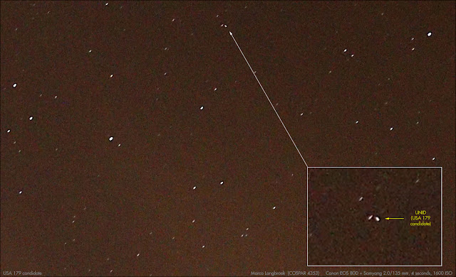
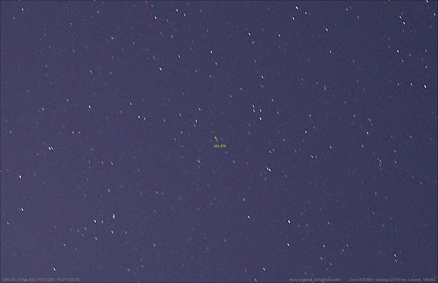
Below are a few more (but not all) objects that I observed late February that hadn't been tracked for a long time. All objects were imaged with a Canon EOS 80D + Samyang 2.0/135 mm lens.

USA 179 (2004-034A) in HEO on 26 Feb 2023. Click image to enlarge

USA 269 (2016-047A) in GEO (click image to enlarge)

USA 278 (2017-056A) in HEO. Click image to enlarge

A possible (hypersonic?) missile test from Cape Canaveral [UPDATED]


click map to enlarge

An odd Navigational Warning, NAVAREA IV 221/23 (text of warning below, areas mapped above), was published on March 1, suggesting a launch from Cape Canaveral with a time window from March 2 tot March 6. The jury is still out on what it is, although opinions are converging on a missile test, possibly a test of the hypersonic LHRW.

010205Z MAR 23
NAVAREA IV 221/23(11,24,25 26,51).
WESTERN NORTH ATLANTIC.
FLORIDA.
1. HAZARDOUS OPERATIONS, ROCKET LAUNCHING
   021700Z TO 062138Z MAR IN AREAS BOUND BY:
   A. 28-32.88N 080-33.89W, 28-28.00N 080-02.00W,
      28-20.00N 080-02.00W, 28-25.62N 080-34.48W.
   B. 28-04.00N 078-49.00W, 28-11.00N 078-47.00W,
      27-53.00N 077-23.00W, 27-44.00N 077-26.00W.
   C. 28-27.00N 080-02.00W, 28-22.00N 079-09.00W,
      28-11.00N 078-47.00W, 28-04.00N 078-49.00W,
      28-03.00N 079-12.00W, 28-20.00N 080-02.00W.
   D. 27-00.00N 063-00.00W, 28-00.00N 059-00.00W,
      27-00.00N 059-00.00W, 26-00.00N 063-00.00W.
   E. 23-30.00N 063-00.00W, 21-30.00N 058-30.00W,
      20-30.00N 058-30.00W, 22-30.00N 063-00.00W.
   F. 28-45.00N 049-00.00W, 30-45.00N 049-00.00W,
      32-00.00N 044-00.00W, 30-00.00N 044-00.00W.
   G. 17-00.00N 048-45.00W, 13-30.00N 041-30.00W,
      11-30.00N 041-30.00W, 15-00.00N 048-45.00W.
2. CANCEL THIS MSG 062238Z MAR 23.


It does not match a scheduled space launch (I initially considered the Terran 1 inaugural launch but noted that the dates do not match) and the seven hazard areas A to G create a pattern with a weird "forked" character, with one leg (A-C-B-E-G) being more or less a straight ballistic trajectory, the other (A-C-B-F-H) suggesting a dog-leg variant.

Twitter user Aerospace001 provided a photograph showing something TEL-like erected at SLC-46:


..and the suggestion that this is a test of LRHW, the Long-Range Hypersonic Weapon under development by the US Army.

Below is a highly simplified reconstruction of what the test might entail, going from the notion that it is a missile test. If it is in fact a hypersonic glider test, the yellow parts of the two trajectory variants might actually look quite different in reality, as such a glider does not follow a ballistic trajectory as depicted, but might manoeuver both in altitude and laterally to the trajectory. 

Both trajectory legs depicted might indicate two variants for the test, possibly at least two test shots.


click map to enlarge


It will be interestingly to see whether or not news on this will follow from the US DoD in the coming days.

More backgrounds on LRHW and this possible test in this article by Tyler Rogoway in the Drive.


UPDATE [6 March 2023 17:05 UTC]:

USA Today reporter Emre Kelly reports on Twitter that DoD sources confirmed a hypersonic test was planned, but that it has been scrubbed.

More also here. Seems a battery issue caused the scrub.

Wednesday 1 March 2023

Tracking the Dark Side on a shoestring budget

From January 23 to 26, 2023, I attended the 2nd NEO and Debris Detection Conference at ESOC in Darmstadt, Germany. I had a poster-presentation on  the work we Independent Space Observers (ISO's) from the SeeSat-L mailinglist do on tracking classified objects.

The resulting 6-page Conference Paper, co-authored by Cees Bassa and Ted Molczan and titled "Tracking the dark Side on a shoestring budget", has now appeared in the on-line conference proceedings. The PDF can be downloaded here.


Abstract: 

A lot of SSA work on earth-orbiting satellites can be done with modest, off the shelf equipment. This has been shown by an informal group of Independent Space Observers (“ISO’s”) organized around the Seesat-L mailing list. They optically track some 200 “classified” objects – objects for which orbital elements are not provided in the public orbital catalogues – using very simple equipment: from binoculars and stopwatch on the ‘old skool’ end to DSLR’s or sensitive CCTV or CMOS/CCD cameras with fast photographic lenses and GPS time management on the sophisticated end. In this paper, a brief outline is provided on the techniques and equipment used by Seesat-L members and an example is given of how a new launch is located and tracked. It is discussed why the whole concept of keeping the orbits of certain space assets “classified” is problematic: not only is it unrealistic, but it also goes against core notions of transparency and accountability regarding activities in space.

Conclusions: 

A group of Independent Space Observers (ISO’s) has demonstrated that tracking large and medium sized artificial objects in earth orbit, and occasionally even smaller ones such as cubesats, using relatively inexpensive equipment made of commercial-off-the- shelf components is feasible. Such relatively low cost equipment could be a way forward to quickly add optical tracking capacity to increasingly strained tracking networks, especially with the rise of mega-constellations. ISO’s have also demonstrated that certain objects whose orbits are kept “classified” by the responsible Nations, can often easily be observed using such equipment. This underlines how highly unrealistic it is to expect that the orbits of certain (military) space assets can be kept ‘secret’. From the viewpoint of Space traffic management, it is actually undesirable to have a situation where the presence of certain classes of tracked objects are kept undisclosed. The practise moreover goes against core notions of transparency and accountability regarding activities in space, such as laid out in Resolution 222 (XXI) of the United Nations (the ‘Outer Space Treaty’