Wednesday 25 October 2023

A Goodbye to Delfi-C3

Delfi-C3 tracklet on a stack of 16 video frames, 24 Oct 2023

 (note: new reentry forecasts are now published in a separate dedicated blogpost)

Earlier this year, my TU Delft colleague Stefano Speretta asked me if I could try to I imaged a pass of the TU Delft-built 3U cubesat Delfi-C3 (2008-021G). 

It next took a long time due to initially unfavourable observing geometries and - when the observing geometries got better - the Dutch weather, but I finally managed to successfuly image it in late evening twilight of 24 October 2023. 

Above is a stack of 16 video frames showing the tracklet created by the cubesat; below is the actual video footage, shot with a WATEC 902H2 Supreme camera and Samyang 2.0/135 mm lens at 25 fps (the object is very faint in the footage, due to it being very small in size):


Delfi-C3 (2008-021G) is a 3U cubesat and was the first cubesat built in the Netherlands. It was launched on 28 April 2008 from Satish Dawan in India on a PSLV rocket, as part of a rideshare mission.

It was built by students of Delft Technical University (my current employer) as the first in what was to become a line of Dutch-designed-and-built cube- and pocketsats. It carried at that time experimental technology (autonomous star sensors and thin-film solar panels) and an amateur radio responder. More information on the cubesat, its mission and the technology onboard can be found at the TU Delft website.

Although no longer operational, there is occasionally still radio telemetry received from the cubesat by our TU Delft Rooftab Radio lab.


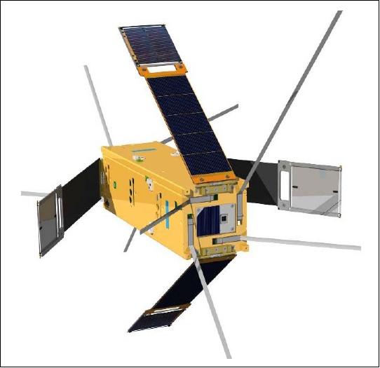
Delfi-C3 in stowed condition (image: TU Delft)


Delfi-C3in deployed condition (image: TU Delft)

Fifteen years after launch, it is time to say Goodbye this very successful cubesat. It has less than half a month to live.


[post NO LONGER UPDATED below. Instead refer to this new dedicated post here for new reentry forecast updates]


Initially launched into a 615 x 635 km, 98.0 inclined orbit, the orbit has now decayed to 321 x 324 km (status as of 3 Nov 2023), and the cubesat is coming down increasingly fast, as can be seen in the diagrams below (currently, the orbit is dropping by 4 km/day (status 3 Nov 2023)):


click diagrams to enlarge

click diagram to enlarge


Delfi-C3 will probably reenter into the atmosphere and burn up somewhere mid-November 2023 (depending on how solar activity develops over November).

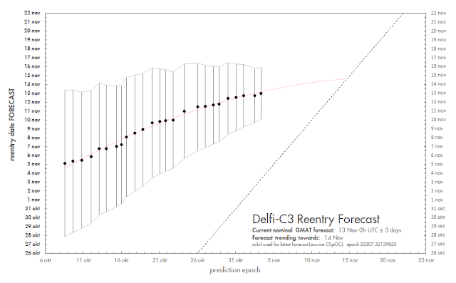
Here is the evolution of my GMAT reentry forecast so far (ignore the error bars and quoted  reentry date uncertainty for now, as this far before reentry they still have little meaning, due to the uncertainty in future solar activity):
click diagram to enlarge

The initial shift of the forecast over time towards a progressively later date is slowing down. My best guess at this moment (3 Nov2023) is reentry mid-November, around 12-14 November 2023, plus-minus a few days.

I will update this figure over the coming days and weeks, as the reentry forecast develops

New reentry forecasts are now published in a separate dedicated blogpost.

I do not expect a TIP to be issued for this object. Recent experience shows that TLE updates will probably cease some 2-3 days before the actual reentry, after which CSpOC issues an 'administrative decay'.

Delfi-C3 is very small and the reentry will be completely harmless, with the cubesat burning up completely.


Sunday 22 October 2023

[UPDATED] A possible Missile Defense Test from Hawaii on October 25-29 (FTM-32?) and another LRHW test from Cape Canaveral


click map to enlarge

 [this post was updated 25 Oct 2023 to include an upcoming LRHW test from Cape Canaveral]


A Navigational Warning (NAVAREA XII 735/23) has appeared  that suggests a Missile Defense test will take place north of Hawaii with a target launched from the Pacific Missile Range Facility at Kauai, Hawaii, in the last week of October. The window runs from October 25 to 29.

200855Z OCT 23
NAVAREA XII 735/23(19).
NORTH PACIFIC.
HAWAII.
1. HAZARDOUS OPERATIONS 251930Z TO 260100Z OCT,
   ALTERNATE 261930Z TO 270100Z,
   271930Z TO 280100Z, 281930Z TO 290100Z OCT
   IN AREA BOUND BY
   22-02.00N 159-47.00W, 22-04.00N 159-52.00W,
   23-52.00N 161-49.00W, 22-37.00N 163-18.00W,
   23-00.00N 164-29.00W, 24-54.00N 164-53.00W,
   27-30.00N 167-44.00W, 29-23.00N 167-44.00W,
   35-17.00N 161-05.00W, 35-46.00N 156-36.00W,
   30-43.00N 152-22.00W, 28-18.00N 152-15.00W,
   27-35.00N 152-48.00W, 26-04.00N 155-40.00W,
   24-19.00N 160-57.00W, 22-09.00N 159-45.00W,
   22-03.00N 159-46.00W.
2. CANCEL THIS MSG 290200Z OCT 23.//

In the map above I have plotted the hazard area from the Navigational Warning. The target launch track from PMRF on Kauai can be seen, as well as a large intercept area.

Although not the same, it is riminiscent for that of test FTM-31 E1a of 30 March this year (see a March blogpost) which was a salvo firing of two SM-6 missiles from the US Navy ship USS Daniel Inouyeto that intercepted a MRBM target fired from PMRF Kauai.

The upcoming test might be FTM-32  (see page 5 of this Congressional document) which reportedly also will be a salvo firing of two SM-6 missiles against an MRBM target [edit: it was actually FTM-48]. The missiles will be fired from a US Navy Guided Missile Cruiser positioned north of Kauai, perhaps USS Carl M. Levin or USS Kidd, who both were seen sailing out of Pearl Harbor recently.

UPDATE 26 Oct 2023:

The test happened on 25 October and involved the interception of multiple targets. The interception was done by the USS Carl M. Levine (DDG120). Two HALO observing aircraft (HALO2 and HALO51) where in the air during the test, along with a US Navy P3, a USAF aircraft and fifth small aircraft. MDA news item on it here and a Naval News story here. It was test FTM-48 codenamed Vigilant Wyvern. The targets consisted of two SRBM's and two cruise missiles, the first intercepted with two SM-3 missiles, the second with two SM-2 missiles.

The MDA released this image of the test, showing one of two SRBM targets being fired from the PMRF Kauai (and the smoke trail of another one):


image: Missile Defence Agency

 They also published this video:

 [end of update]


LRHW Test from Cape Canaveral

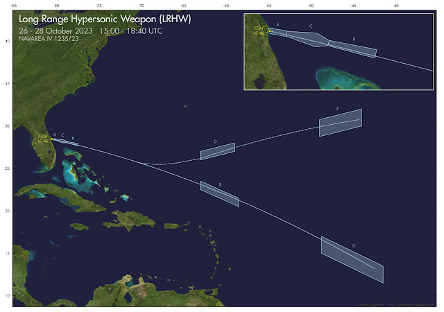
Meanwhile, another Navigational Warning, NAVAREA IV 1235/23, is pointing to yet another test of the Long Range Hypersonic Weapon (LRHW) from Cape Canaveral on October 26-28:


241619Z OCT 23
NAVAREA IV 1235/23(GEN).
NORTH ATLANTIC.
FLORIDA.
1. HAZARDOUS OPERATIONS 261500Z TO
   281840Z OCT.
   IN AREAS BOUND BY:
A. 28-32.93N 080-33.90W, 28-28.00N 080-02.00W,
   28-18.00N 080-02.00W, 28-23.00N 080-31.00W,
   28-25.64N 080-34.47W.
B. 28-02.00N 078-50.00W, 28-11.00N 078-47.00W,
   27-55.00N 077-24.00W, 27-40.00N 077-27.00W.
C. 28-27.00N 080-02.00W, 28-24.00N 079-09.00W,
   28-11.00N 078-47.00W, 28-02.00N 078-50.00W,
   28-00.00N 079-12.00W, 28-18.00N 080-02.00W.
D. 27-00.00N 063-00.00W, 28-00.00N 059-00.00W,
   27-00.00N 059-00.00W, 26-00.00N 063-00.00W.
E. 23-30.00N 063-00.00W, 21-30.00N 058-30.00W,
   20-30.00N 058-30.00W, 22-30.00N 063-00.00W.
F. 28-45.00N 049-00.00W, 30-45.00N 049-00.00W,
   32-00.00N 044-00.00W, 30-00.00N 044-00.00W.
G. 17-00.00N 048-45.00W, 13-30.00N 041-30.00W,
   11-30.00N 041-30.00W, 15-00.00N 048-45.00W.
2. CANCEL THIS MSG 281940Z OCT 23.

click map to enlarge

Two earlier LRHW test attempts, in March (see this blogpost) and in September (see this blogpost) were aborted. Maybe third time is a charm.

UPDATE: this LHRW test was scrubbed as well.

Friday 13 October 2023

Did Russia position a geostationary satellite over Israel last month? No.

screenshot quote Budanov in interview with Ukranian Pravda
 

Based on this interview with Kyrylo Budanov, the Chief of the Intelligence Directorate of the Ukranian military, in the Ukranian Pravda newspaper, a story is going around claiming that Russia relocated a geostationary satellite over Israel in the last week of September, with the suggestion that this was part of an operation to help Iran and the terror organisation Hamas to commit the latter's atrocious assault on Israel.

I was asked by a journalist and a number of people on social media whether I had any evidence that could confirm Budanov's claim. 

In short: this claim cannot be substantiated and makes little sense.

The date mentioned (24 September) for the purported relocation implies that the satellite in question should be LUCH (OLYMP) 2 (2023-031A).  This is the second in the OLYMP-K series of SIGINT satellites operated by the Russian military, and was launched in March of this year.

Below is a plot of the longitudes of all operational Russian geostationary assets (civilian and military) in a wide swat of longitude spanning Africa to west Asia. Only LUCH (OLYMP) 2, indicated by the larger red dots, changes position starting near the mentioned date of September 25/26 (the relocation was completed by October 4), moving from 9.0 E to 3.2 E.

(the other satellite slowly drifting from 7 E to 15E, is the commercial satellite EXPRESS AM-33 which has been drifting for over a year, since august 2022).


click diagram to enlarge


Given the date quoted, Budanov's remarks clearly seem to indicate LUCH (OLYMP) 2 as the satellite in question. But it makes no sense, because:

(1) moving from longitude 9 E to 3.2 E, it is not located near Israel, the difference in longitude being almost 30 degrees;

(2) it is moving westwards, away rather than towards the longitude of Israel.

So Budanov's claim is quite a stretch (and I wonder if someone in his staff perhaps simply misinterpreted "3.2 E" as "32 E" and jumped the gun).

Moreover, the repositioning of the satellite has to be seen in the light that this is an OLYMP-K class satellite

These SIGINT satellites serve a similar role as the US satellite PAN (see my 2016 article in The Space Review for more on PAN): they rove from commercial telecom satellite to commercial telecom satellite, to eavesdrop on communications and map which sources are utilizing the satellite. Hence, their targets of interest are other satellites.

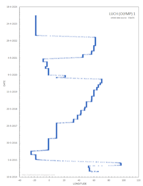
This behaviour can be well seen in this plot of longitude over time for LUCH (OLYMP) 2's predecessor, LUCH (OLYMP) 1  (2014-058A, aka 'OLYMP-K'). At least 24 relocations over the past 9 years can be seen (and each time, it was put next to another commercial telecom satellite:

LUCH (OLYMP) 1 behaviour. Click to enlarge


The newer sistership,  LUCH (OLYMP) 2 has only recently been launched, on 12 March 2023. In the 8 months since, it has been relocated 3 times (including the relocation now under discussion):

LUCH (OLYMP) 2 behaviour. Click image to enlarge


It is clearly following in the footsteps of its predecessor LUCH (OLYMP) 1, as it too is put close to commercial telecom satellites during these relocations

For example, here it is on September 20 (a few days before its last relocation) imaged by me from Leiden in the Netherlands. At that time the satellite was positioned very close to Eutelsat (KA Sat) 9A - the true distance between the two satellites was about 22 km at the moment of imaging:


click to enlarge


 And here it is on October 14, after relocation to 3.2 E, close to Eutelsat 3B:


click to enlarge

The targets of  LUCH/OLYMP satellites are other geostationary satellites, on which they eavesdrop. That they frequently relocate, is a normal, well-established pattern.

Combined with the fact that LUCH (OLYMP) 2 is actually not located over Israel at all but almost 30 degrees more West in longitude, there is no credible evidence that the late September relocation had anything to do with the events in Israel on October 7.

Thursday 5 October 2023

Paper in Nature on the high optical Brightness of the BlueWalker 3 satellite


Last Monday 2 October 2023,  a consortium paper initiated by the IAU-CPS was published in the high-impact Journal Nature. It is titled "The high optical brightness of the BlueWalker 3 satellite", and I am one of the co-authors of this paper. An Open Acces version of the paper is here.

The BlueWalker 3 satellite (2022-111AL), launched in September 2022 into a 500 km altitude Low Earth Orbit, is a prototype satellite from AST Space Mobile. It is meant to demonstrate the feasibility of making direct contact with normal cell phones through a satellite

Eventually, AST Space Mobile wants to create a constellation with large numbers of these satellites (it filed with the FCC for 243 of such satellites, although lower operational numbers are also floating about on the internet. AST Space Mobile has said that they need at least 110 operational satellites to provide world coverage). Launch of operational versions might start in 2024.


 BlueWalker 3 filmed on 3 April 2023

The paper provides the results of our monitoring of the brightness of the satellite, before and after deployment of its large 64 m2 Phased Array antenna. We show that the satellite is very bright, brighter than satellites generally are, shining as bright as some of the brightest stars in the sky. It reaches magnitude +0.5 to zero on well illuminated passes. 

We discuss what this means for the outlook of the night sky, it's impact on Astronomy, and point to the mitigation efforts astronomical Observatories might need to take if large numbers of such satellites will be launched. At the end of the paper, we make a call that the impact of such satellite constellations should be made an explicit part of launch permit assessments.

While BlueWalker 3 and the proposed constellation of similar satellites are the inspiration for our paper, the implications stemming from our paper are explicitly relevant to a wider issue of the rise of large satellite constellations, and the impact these will have on the night sky and users of the night sky (which, by the way, are not just astronomers).

More backgrounds on the topic and my involvement with the study are provided in this interview with me on the website of Delft Technical University.