 |
| click map to enlarge |
Starship Flight Test 3 (see this earlier pre-launch post) was largely a success. Starship FT 3 launched from Boca Chica at 13:25 UTC (March 14, 2024) and was successfully inserted on a sub-orbital trajectory. The stage separations went well, coasting went well, and so did various other attempted milestones (such as briefly opening the cargo bay doors in space).
There were a few small mishaps: an attempt to make a controlled water-landing of the first stage went awry, and so did the final controlled reentry attempt of Starship itself over the Indian Ocean. But in all, this was a successful test flight, providing exciting imagery during the launch and flight to boot (see end of this post).
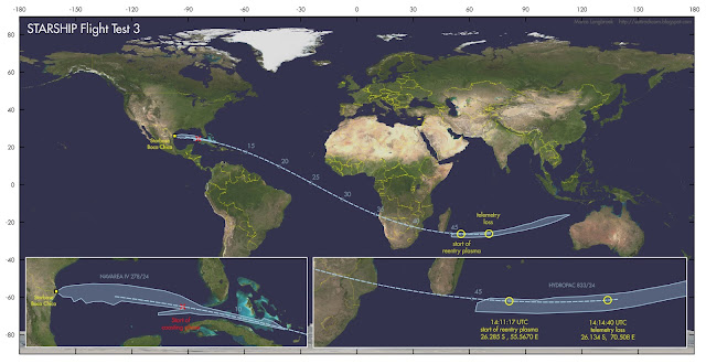
In this post, I will try to reconstruct the approximate points of reentry: the point (at 100 km altitude) where the reentry plasma formation started, and the point were telemetry was lost (and Starship presumably disintegrated, at 65 km altitude).
The base of my reconstruction is this pre-launch TLE that I constructed for launch at 13:25:00 UTC:
STARSHIP FT3 for launch on 14 March 2024 13:25:00 UTC
1 70000U 24999A 24074.55902778 .00000000 00000-0 00000-0 0 03
2 70000 026.3000 177.8817 0153183 289.7760 142.6230 16.45958778 07
I was able to check and calibrate this elset, making use of a prominent landmark on earth visible in the webcast just before reentry started.
At Mission
Elapsed Time (MET) 00:44:09, corresponding to 14:09:09 UTC, Lake Anony
on Madagascar can be briefly seen:
 | ||
| screenshot from the SpaceX webcast at MET 00:44:09 showing Lake Anony |
 |
| The geographical area in question in a Google Earth image |
This allowed to check with the trajectory based on my pre-launch estimated TLE. It shows that my TLE estimate basically puts the trajectory in the correct position, but that it is 27 seconds "late" on the real flight path, and a bit too low in altitude.
Two minutes later, at MET 00:46:17 (corresponding to 14:11:17 UTC), at 100 km altitude, the first clear reentry plasma can be seen forming as a red glow around the fins of Starship. This is reference point one:
 |
| Screenshot from SpaceX webcast. Click image to enlarge |
Slightly over 3.5 minutes later, at 65 km altitude at MET 00:49:40 (corresponding to 14:14:40 UTC), telemetry is lost, and this presumably is where Starship disintegrated. This is reference point number two.
Knowing that my pre-launch TLE is 27 seconds "late", we can deduce approximate positions for reference point one (start of plasma formation) and reference point two (loss of telemetry and presumed disintegration) using the TLE.
They are at respectively 26.30 S, 55.68 E for the start of the Plasma formation, and 26.10 S, 70.87 E for telemetry loss and presumed disintegration, as indicated by the two yellow circles in the map below:
 |
| click map to enlarge |
This also confirms that the controlled reentry aimed for the western part of the HYDROPAC 833/24 hazard zone (see discussion in my earlier pre-launch post here), as suggested by Jonathan McDowell, and that the eastern part of that zone was safety overshoot in case the controlled deorbit burn failed and Starship would continue on a ballistic trajectory.
UPDATE 15 March 2024 18:30 UTC:
I reanalysed the trajectory, using altitude data from the SpaceX webcast to create a TLE that matches the altitude against Mission Elapsed Time (MET), fits the hazard areas from the Navigational Warnings, and results in a pass south of Lake Anony in Madagascar at the correct MET:
STARSHIP FT revised elset -50 x 235 km
1 70012U 24999A 24074.55902778 .00000000 00000-0 00000-0 0 06
2 70012 026.3000 177.8795 0220000 355.7000 077.5000 16.67947166 01
As can be seen in the diagram below, this elset has a close fit to the altitudes from the SpaceX webcast (the blue dotted line is a polynomial through the altitudes from the webcast; the red crosses are the altitudes given by the TLE):
 |
| click diagram to enlarge |
The resulting position for reference point one (start of plasma formation) is 26.28 S, 55.57 E. The resulting position for reference point two (loss of telemetry and presumed disintegration) is 26.13 S, 70.51 E.
 |
| click map to enlarge |
The point where, 00:08:35 after launch, Starship started its coasting phase after engine cut-off is 24.491 N, 84.633 W (150 km altitude).
[end of update]
A few more images of the launch (screenshots from the SpaceX webcast):
 |
| screenshots from SpaceX webcast |


No comments:
Post a Comment