Sunday, 25 September 2022

USA 338, the NROL-91 payload, observed

NROL-91. Click image to enlarge

On 24 September 2022 at 22:25:30 UT, with half an hour delay, ULA launched NROL-91, a Delta IV Heavy with a classified payload for the NRO. The payload is probably an electro-optical reconnaissance satellite in the KH-11 lineage (for more backgrounds see the previous post).

Six hours after the launch, the payload, USA 338, made a pass over the Netherlands and around 4:17 UTC (6:17 local time) was observed by Cees Bassa from Dwingeloo and by me from Leiden. It was visible by the naked eye with a brightness around magnitude +2.5 to +3.

The image above shows it ascending over the roof of my house, passing close to the Hyades cluster in Taurus. The image was taken with a Canon EOS 80D + Samyang 1.4/35 mm lens, 5 seconds at ISO 800. The sky was clear but with sacttered clouds, as can be seen in the image.

A very preliminary orbit fit suggests a 73.59 degree inclined, 376 x 415 km orbit. The RAAN difference with USA 290, an earlier launch of similar type, is ~99 degrees. When the orbit gets better established, these figures might still change somewhat.


Wednesday, 21 September 2022

NROL-91: a new (possibly electro-optical) sister ship of USA 290


click map to enlarge

On 24 September 2022 at 21:53 UT, an ULA Atlas Delta IV Heavy (the last to be launched from Vandenberg) will launch from Vandenberg SFB Launch Complex 6 as NROL-91, carrying a classified payload into Low Earth Orbit for the NRO.

The launch is in southernly direction. The locations of the four hazard areas from the published Navigational Warnings (see map above and text below) are consistent with launch into an orbital inclination of 73.6 degrees, which is similar to NROL-71 from January 2019 that launched USA 290 (2019-004A). 

So the NROL-91 payload likely is a sister ship to USA 290.

Below is Navigational Warning HYDROPAC 2592/22 for the launch (note that there appears to be a clerical error in the first coordinate of area C):

122224Z SEP 22
HYDROPAC 2592/22(GEN).
EASTERN PACIFIC.
CALIFORNIA.
1. HAZARDOUS OPERATIONS:
   A. 242020Z TO 242347Z SEP, ALTERNATE
      2020Z TO 2347Z DAILY 25 THRU 27 SEP
      IN AREA BOUND BY
      33-53.00N 120-23.00W, 34-28.00N 120-40.00W,
      34-39.00N 120-40.00W, 34-39.00N 120-35.00W,
      34-27.00N 120-25.00W, 33-55.00N 120-18.00W.
   B. 242020Z TO 242345Z SEP, ALTERNATE
      2020Z TO 2345Z DAILY 25 THRU 27 SEP
      IN AREA BOUND BY
      25-18.00N 117-07.00W, 25-12.00N 117-27.00W,
      26-35.00N 117-53.00W, 26-41.00N 117-33.00W.
   C. 242020Z TO 242345Z SEP, ALTERNATE
      2020Z TO 2345Z DAILY 25 THRU 27 SEP
      IN AREA BOUND BY
      00-17.00S 121-28.00W, 00-07.00S 110-21.00W,
      03-24.00S 109-33.00W, 03-24.00S 110-21.00W.
   D. 242242Z TO 250133Z SEP, ALTERNATE
      2242Z TO 0133Z DAILY 25 THRU 27 SEP
      IN AREA BOUND BY
      17-57.00N 140-23.00W, 06-13.00N 137-52.00W,
      06-30.00N 136-25.00W, 18-15.00N 138-53.00W.
2. CANCEL THIS MSG 280233Z SEP 22.// 

A second Navigational Warning for this launch, NAVAREA XII 695/22, is identical.

The locations of the first three hazard areas A to C from the Navigational Warning are indeed very similar to those for NROL-71 in 2019: compare for example to this map for NROL-71 from this december 2018 post:


NROL-71 from January 2019. click to enlarge


Area D, the upper stage deorbit area, is situated slightly more south and is a bit more elongated than it was for NROL-71, for unclear reasons. The upper stage deorbit happens at the end of the first revolution. The deorbit burn might be visible from central Asia around 23:10-23:20 UTC.

In 2019, NROL-71 was launched into a 395 x 420 km, 73.6 degree inclined non-sun-synchronous orbit and I expect the orbit of the NROL-91 payload to be very similar.

Here is my pre-launch orbital estimate for the NROL-91 payload based on this assumption:


NROL-91                      for launch on 24 Sep 2022 at 21:53:00 UT
1 70001U 22999A   22267.91180556  .00000000  00000-0  00000-0 0    06
2 70001 073.6000 044.7175 0018421 155.1634 324.7303 15.53162541    00


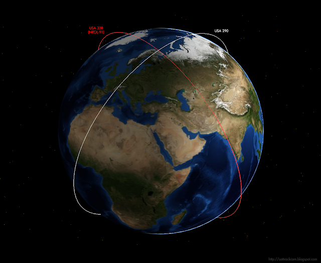
If NROL-91 indeed launches at 21:53 UT on the 24th, the orbital planes of the payload and USA 290 will end up at a 90-degree angle to each other, as can be seen in the polar view below:

polar view of the orbital plane relative to that of USA 290. Click to enlarge


If the launch is scrubbed on the 24th, and if indeed this specific orbital plane at 90-degree angle to that of USA 290 is aimed for, the launch time will shift ~13 minutes earlier each day.

USA 290 at the time was widely believed to be a new generation electro-optical reconnaissance (IMINT) satellite, a follow-on on the KH-11 ENHANCED CRYSTAL program. That it was launched, as NROL-91 will be, in a non-sun-synchronous orbit is odd though, for an optical reconnaissance satellite. 

One really wonders why the sun-synchronous polar orbit typical for such missions (and typical for earlier generation KH-11 EVOLVED ADVANCED CRYSTAL missions) was dropped in favour of this new 73.6 degree orbital plane. What is the advantage of this new orbital configuration? Or are USA 290 and NROL-91 perhaps not electro-optical systems, but something else?

Wednesday, 7 September 2022

Kosmos 2558 keeping its orbit close to USA 326 [UPDATED]

 [updated 9 Sept 2022 20:00 UTC]


In a series of previous blogposts (here, here and here) I wrote about a cat-and-mouse game going on in space, where the recently launched Russian satellite Kosmos 2558 (2022-089A) is stalking the US spy satellite USA 326 (2022-009A).

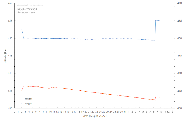
That game of cat-and-mouse is still ongoing. Over the past week, Kosmos 2558 has been making adjustments to its orbital inclination (see the diagram above). 

At first glance, you would say that it is apparently moving its orbit away from USA 326, as it is increasing the difference in orbital inclination.

But that is deceptive. The difference in orbital inclination between the two objects is actually very small (currently 0.2 degrees), and so is the difference in RAAN (currently 0.26 degrees). The two objects basically share the same orbital plane.

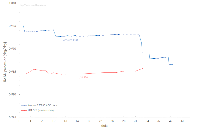
So why the adjustments in orbital inclination? If you look at the diagram below, which depicts the effects of the orbital inclination adjustments on the precession of the RAAN (i.e. the drift of the node of the orbit), you will note that the effect is that the RAAN precession starts to more closely match that of USA 326.

In other words:  the adjustment is actually in order to get the precession of the two orbital planes synchronised, i.e. to make sure the orbital planes do not drift too far apart. This ensures that the two objects will continue to share virtually the same orbital plane.


Click diagrams to enlarge 


Because Kosmos 2558, while sharing the same orbital plane as USA 326, is orbiting at a slightly lower orbital altitude than USA 326 (on average some 60 km lower), its orbital inclination needs to be slightly different from that of USA 326 in order to maintain a similar RAAN precession: the rate of RAAN precession depends on both the inclination and orbital altitude.

The fact that it is making adjustments to synchronize its rate of RAAN precession with that of USA 326, again makes clear that the launch of Kosmos 2558 into the orbital plane of USA 326 is no coincidence.

The image below shows how closely the orbital planes match: the main difference is a relatively small difference in altitude. This results in slightly different orbital periods for both satellites, and as a result Kosmos 2558 is 'taking over' USA 326 every 5 days, resulting in flyby's at distances of 60 to 80 km each 5 days.


click image to enlarge


UPDATE 9 Sept 2022 20:00 UTC:

Kosmos 2558 made an orbit raising manoeuvre on 8 September 2022 around 11:10 UTC, raising apogee by 5.5 km and perigee by 1 km. It also adjusted its orbital inclination again, to get the RAAN precession closer to that of USA 329:


click diagram to enlarge

click diagram to enlarge